Peninsula which forms part of Marie Byrd Land in Antarctica
This article relies largely or entirely on a single source. Relevant discussion may be found on the talk page. Please help improve this article by introducing citations to additional sources. Find sources: "King Edward VII Land" – news · newspapers · books · scholar · JSTOR(November 2021)
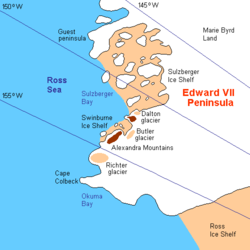
Location of King Edward VII Land (marked in orange) within the Ross DependencyArea map of Edward VII Peninsula
King Edward VII Land or King Edward VII Peninsula is a large, ice-covered peninsula which forms the northwestern extremity of Marie Byrd Land in Antarctica.[1] The peninsula projects into the Ross Sea between Sulzberger Bay and the northeast corner of the Ross Ice Shelf, and forms part of the Ross Dependency. Edward VII Peninsula is defined by the Ross Ice Shelf on the southwest, Okuma Bay on the west, and to the east by Sulzberger Bay and the Saunders Coast, all essentially on the Ross Sea / Southern Ocean in Antarctica. The northwest extremity of the peninsula is Cape Colbeck. Edward VII Peninsula is located at 77°40′S155°00′W / 77.667°S 155.000°W / -77.667; -155.000.
The western coast is Shirase Coast. In the north and east the Swinburne Ice Shelf is located.
Edward VII Peninsula was discovered on 30 January 1902 by the British National Antarctic Expedition (BrNAE) (1901–1904) under Robert Falcon Scott, who named it King Edward VII Land for King Edward VII of the United Kingdom. The coastline was further explored by the Nimrod Expedition under Ernest Shackleton in 1908–09, and the first landfall was made by a party of the Japanese Antarctic Expedition led by Shirase Nobu in 1912. The region was renamed "Edward VII Peninsula" after the peninsular character of the region was determined by exploration conducted by the Byrd Antarctic Expedition (1933–1935) and the United States Antarctic Service (USAS) Expedition (1939–1941).
Most of the peninsula is within the Ross Dependency, claimed by New Zealand (see Territorial claims of Antarctica).
^Wade, F. Alton (1945). "The Geology of the Rockefeller Mountains, King Edward VII Land, Antarctica". Proceedings of the American Philosophical Society. 89 (1): 67–77.
and 24 Related for: King Edward VII Land information
KingEdwardVIILand or KingEdwardVII Peninsula is a large, ice-covered peninsula which forms the northwestern extremity of Marie Byrd Land in Antarctica...
significant achievements. These included the first landing on the coast of KingEdwardVIILand, the fastest recorded sledging journey, and the most easterly point...
nautical miles (93 km; 58 mi) wide bordering the coast of Marie Byrd Land between EdwardVII Peninsula and Guest Peninsula in Antarctica. The Sulzberger Ice...
other parties explored Victoria Land and the Western Mountains. An attempted landing and exploration of KingEdwardVIILand was unsuccessful. A journey to...
corpulent British KingEdwardVII to have sex with two women simultaneously while protecting them from being crushed by his weight. KingEdward was known for...
Henry VII (28 January 1457 – 21 April 1509) was King of England and Lord of Ireland from his seizure of the crown on 22 August 1485 until his death in...
Byrd Canyon (75°30′S 157°15′W / 75.500°S 157.250°W / -75.500; -157.250) is an undersea canyon[where?] named for Admiral Richard E. Byrd. The name was...
which have been named. This list may not reflects recent namings. KingEdwardVIILand is a peninsula in the Ross Dependency. Blades Glacier Butler Glacier...
The Rockefeller Mountains are on the south side of the EdwardVII Peninsula in Marie Byrd Land, to the south of the Alexandra Mountains. They are north...
77°50'S 158°20'W on the Ross Ice Shelf of Antarctica at its juncture with EdwardVII Peninsula. It was discovered by the British National Antarctic Expedition...
Siple Coast (82°0′S 155°0′W / 82.000°S 155.000°W / -82.000; -155.000) is the middle portion of the relatively ill-defined coast along the east side...
separated mountains in the north portion of EdwardVII Peninsula, just southwest of Sulzberger Bay in Marie Byrd Land, Antarctica. The Alexandra Mountains were...
The KingEdwardVII Bridge is a railway bridge spanning the River Tyne between Newcastle upon Tyne and Gateshead, in North East England. It is a Grade...
Christensen Coast and Ingrid Christensen Coast. It is part of Mac. Robertson Land. The name "Cape Amery" was applied to a coastal angle mapped on 11 February...
included the discoveries of the Cape Crozier emperor penguin colony, KingEdwardVIILand, and the Polar Plateau (via the western mountains route) on which...
provided with 23,492 New Zealand “Penny Universal” stamps, overprinted “KingEdwardVIILand”, for use on the expedition. Postmaster Shackleton was provided with...
Discovery in 1902. He named the peninsula adjacent to the Ross Sea KingEdwardVIILand and the scattered outcrops that were within sight, the Alexandra...
The mountain was named in 1915 after KingEdwardVII. KingEdward Peak should not be confused with Mt. KingEdward (3,490 m (11,450 ft)), located on the...
On returning home, Shackleton was knighted for his achievements by KingEdwardVII. After the race to the South Pole ended in December 1911, with Roald...
Bay is on the Southern Ocean coast of Marie Byrd Land. It extends along the coast of the EdwardVII Peninsula from Fisher Island to Vollmer Island. The...
the vicinity of Charcot Island, and West Base, in the vicinity of KingEdwardVIILand. After operating successfully for two years but with international...
inlet, about 16 nautical miles (30 km) wide, indenting the north coast of EdwardVII Peninsula just east of Cape Colbeck. It was mapped from surveys by the...
 Global Information