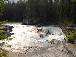
The Kicking Horse River is in the Canadian Rockies of southeastern British Columbia, Canada.[2] The river was named in 1858, when James Hector, a member of the Palliser Expedition, reported being kicked by his packhorse while exploring the river. Hector named the river and the associated pass as a result of the incident. The Kicking Horse Pass, which connects through the Rockies to the valley of the Bow River, was the route through the mountains subsequently taken by the Canadian Pacific Railway when it was constructed during the 1880s. The railway's Big Hill and associated Spiral Tunnels are in the Kicking Horse valley and were necessitated by the steep rate of descent of the river and its valley.
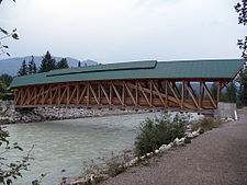
Kicking Horse Pedestrian BridgeKicking Horse River at Park Bridge rest area near Golden. Trans Canada Highway on left, CPR mainline on rightKicking Horse River at the feet of Chancellor Peak
Kicking Horse Pedestrian Bridge in Golden is the longest authentic covered timber-frame bridge in Canada.[3] Planned as a community project by the Timber Framers Guild, local volunteers were joined by carpenters and timber framers from Canada, the United States and Europe. The bridge structure is 150 feet (46 m) long, with a 210,000-pound (95,000 kg) Burr arch structure. The bridge was completed in September 2001.
The Trans-Canada Highway traverses the river at several points from Yoho National Park to Golden, British Columbia. The river is spanned by the new Park Bridge. Kicking Horse Mountain Resort, named for the river and pass, is located in the Dogtooth Range of the Purcell Mountains, on the west side of the town of Golden.
^ ab"Archived Hydrometric Data Search". Water Survey of Canada. Archived from the original on February 21, 2009. Retrieved October 19, 2008. Search for Station 08NA006 Kicking Horse River near Golden
^"Kicking Horse River". BC Geographical Names.
^"Kicking Horse Pedestrian Bridge". Tourism Golden. Archived from the original on 2008-11-21. Retrieved 2008-08-21.
and 25 Related for: Kicking Horse River information
Tunnels are in the KickingHorse valley and were necessitated by the steep rate of descent of the river and its valley. KickingHorse Pedestrian Bridge...
adjacent KickingHorseRiver were named after James Hector (Hector's Branch Expeditions, 3 August 1858 – 26 May 1859), was kicked by his horse while attempting...
KickingHorse may refer to: KickingHorseRiver in the Canadian Rockies, southeastern British Columbia, Canada KickingHorse Mountain Resort, named after...
American ski resort. The resort, named after the nearby KickingHorseRiver and KickingHorse Pass, spans the easternmost slope of the Purcell Mountains...
several features that are good for river surfing. The KickingHorseRiver is a small tributary of the Columbia River located in eastern British Columbia...
Mount Stephen, 3,199 m (10,495 ft), is a mountain located in the KickingHorseRiver Valley of Yoho National Park, 1⁄2 km east of Field, British Columbia...
descended from Wapta Lake to the base of Mount Stephen, along the KickingHorseRiver to a point just west of Field, then rose again to meet the original...
Otterhead River and an Ottertail River (both of which join the KickingHorse downstream from the Amiskwi), there is also a Beaverfoot River (also a Kicking Horse...
the Bow River east to Hudson Bay and the Arctic Ocean, and the other side draining west to the Pacific Ocean by way of the KickingHorseRiver. Committee's...
located in the southwest buttress of Burgess Pass in the Emerald River and KickingHorseRiver Valleys. It was named in 1886 by astronomer Otto Klotz after...
Brook and Blue Creek in Yoho National Park, and is the source of the KickingHorseRiver. The Trans-Canada Highway passes on the north shore of the lake,...
range extends from Cedared Creek near Spillimacheen north to the KickingHorseRiver. This range includes the following mountains and peaks: "Topographic...
Liard River Muskwa River Kechika River Gataga River Toad River Columbia RiverKickingHorseRiver Blaeberry River Bush River Wood River Bitterroot River Kootenay...
part of the Ottertail Range. Chancellor Peak is a landmark in the KickingHorseRiver valley and can be seen from the Trans-Canada Highway midway between...
confluence of the KickingHorseRiver, and the east foot of the Rogers Pass, at the head of Kinbasket Lake and the mouth of the Beaver River. Its length is...
(4,900 ft). The KickingHorseRiver, a Canadian Heritage River, originates in the Wapta and Waputik icefields in the park. This river has created a natural...
the northwest, the watershed boundary between the Vermilion River and the KickingHorseRiver serves as the boundary between Kootenay and Yoho National...
Vaux is a 3,310-metre (10,860-foot) mountain summit located in the KickingHorseRiver valley of Yoho National Park, in the Ottertail Range of the Canadian...
main conduit through which horses and the plains culture diffused into the Columbia River region. Other peoples acquired horses and aspects of the plains...
Upper Spiral Tunnel in KickingHorse Pass. The 112-car grain train with three locomotives derailed into the KickingHorseRiver just after the Trans Canada...
parks: Mount Revelstoke, Glacier, and Yoho. Highway 1 enters Alberta at KickingHorse Pass near Banff National Park. Highway 1 was preceded by several overland...
The Yoho River is a silty, swift tributary of the KickingHorseRiver in the Canadian province of British Columbia. The river is entirely within Yoho National...
of specific rivers. The Canadian Heritage Rivers System was established in 1984. The first Canadian Heritage River was the French River in Ontario, designated...
 Global Information