This article needs additional citations for verification. Please help improve this article by adding citations to reliable sources. Unsourced material may be challenged and removed. Find sources: "Kichi Zibi Mikan" – news · newspapers · books · scholar · JSTOR(November 2022) (Learn how and when to remove this message)
Scenic parkway in Ottawa, Ontario, Canada
Kichi Zībī Mīkan
formerly Sir John A. Macdonald Parkway
Kichi Zībī Mīkan highlighted in red
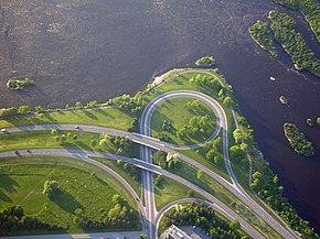
Interchange with Parkdale Avenue
Route information
Maintained by National Capital Commission
Length
9.4 km (5.8 mi)
Major junctions
West end
Carling Avenue
East end
Booth Street
Location
Country
Canada
Province
Ontario
Major cities
Ottawa
Highway system
Roads in Ontario
Federal arteries
(in alphabetical order)
← Island Park Drive
Kichi Zibi Mīkan
Sir George-Étienne Cartier Parkway →
The Kichi Zībī Mīkan,[1] (/ˈkɪtʃiːziːbiːˈmiːkʌn/ki-chee zee-bee MEE-kun)[2] formerly the Sir John A. Macdonald Parkway, and previously the Ottawa River Parkway, is a four-lane scenic parkway along the Ottawa River in Ottawa, Ontario, Canada. It runs from Carling Avenue near Connaught Avenue, to Booth Street at the Canadian War Museum and National Holocaust Monument. It is maintained by the National Capital Commission. The speed limit is 60 km/h (37 mph). Bicycles are allowed on the road and on a parallel recreational path along the parkway.
Besides being a scenic route, it serves as a commuter artery for westend residents who work in the downtown area, particularly government employees who work at the Tunney's Pasture office complex, and other areas. It is also used by the transit systems of Ottawa and Gatineau for express buses.
^"Ottawa's Sir John A. Macdonald Parkway renamed Kichi Zībī Mīkan". cbc.ca. CBC News. June 22, 2023. Retrieved June 23, 2023.
^"Renaming process: Kichi Zībī Mīkan". National Capital Commission. Retrieved 30 June 2023.
The KichiZībīMīkan, (/ˈkɪtʃiː ziːbiː ˈmiːkʌn/ ki-chee zee-bee MEE-kun) formerly the Sir John A. Macdonald Parkway, and previously the Ottawa River Parkway...
Drive Jeanne d'Arc Boulevard Jockvale Road Katimavik Road Kent Street KichiZibiMikan Kinburn Side Road King Edward Avenue Kirkwood Avenue Laurier Avenue...
Westboro village, where the below-grade transitway segment joins the KichiZībīMīkan. The station is named after nearby Dominion Avenue. Opened on 29 November...
LeBreton Flats. About half of the total area, on the south side of the KichiZibiMikan, is undergoing redevelopment. The population was 620 (2016 Census)...
thoroughfare. To the east, it connects to Rideau Street, and to the west, the KichiZibiMikan. South of Wellington is Sparks Street, most of which is a pedestrian...
road in Ottawa, Ontario, Canada's west end. It runs south from the KichiZibiMikan through Baseline Road and Barrhaven to just short of Prince of Wales...
and several embassies line the street. The north end connects to the KichiZibiMikan and the Champlain Bridge, which crosses the Ottawa River into Gatineau...
a station on Ottawa's transitway located at Carling Avenue and the KichiZibiMikan. It is adjacent to the now-shuttered Lincoln Fields Shopping Centre...
Dominion station and Lincoln Fields station where buses travel on the KichiZibiMikan a little over 4 kilometres (2.5 mi) without stopping. The plan calls...
Commissioners Park) pathways (i.e., Capital Pathway) scenic parkways (e.g., KichiZibiMikan, Sir George-Étienne Cartier Parkway) real property and heritage buildings...
River Parkway to the Sir John A. Macdonald Parkway, now renamed to the KichiZibiMikan.[citation needed] In 2014, Plamondon was appointed by the Government...
 Global Information