Khunti (shared with Simdega, Ranchi and Seraikela Kharsawan districts)
• Vidhan Sabha constituencies
3
Area
• Total
2,535 km2 (979 sq mi)
Population
(2011)
• Total
531,885
• Density
210/km2 (540/sq mi)
Demographics
• Literacy
63.86%
• Sex ratio
994
Time zone
UTC+05:30 (IST)
Vehicle registration
JH-23
Website
khunti.nic.in
Khunti district is one of the twenty-four districts in South Chotanagpur division of the Indian state of Jharkhand. The district of Khunti was carved out of Ranchi district on 12 September 2007. As of 2011[update], it is the second least populous district of Jharkhand (out of 24), after Lohardaga.[1] Khunti town is the headquarters of the district. It is historically known as the birthplace of Birsa Munda, and being the centre of activity of the Birsa movement. It is the part of State Capital Region (SCR). [2][3]
The district is currently a part of the Red Corridor.[4]
^"District Census Handbook: Khunti" (PDF). censusindia.gov.in. Registrar General and Census Commissioner of India. 2011.
^Birsa Mumda commemorative postage stamp and biography India Post, 15 November 1988.
^"83 districts under the Security Related Expenditure Scheme". IntelliBriefs. 2009-12-11. Archived from the original on 2011-10-27. Retrieved 2011-09-17.
Khuntidistrict is one of the twenty-four districts in South Chotanagpur division of the Indian state of Jharkhand. The district of Khunti was carved out...
Khunti is the headquarter of Khuntidistrict in the Indian state of Jharkhand. It is in South Chotanagpur division and one of the 24 districts in the Indian...
constituency covers all of Khunti and Simdega districts and parts of Ranchi and Seraikela Kharsawan districts. The Khunti Lok Sabha constituency comprises...
state had 18 districts. Later, six more districts were carved out by reorganizing these districts. The 23rd and 24th districts- Khunti and Ramgarh (carved...
The Pathalgadi movement was started by tribals in Khuntidistrict of Jharkhand as a resistance movement to assert their rights, including the right to...
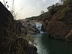
Panchghagh Falls is a waterfall located in Khuntidistrict in the Indian state of Jharkhand. 8km 5miles Dombari Buru North Karo River South Koel River...
Chaibasa is the district headquarters. The district is bounded on north by Khuntidistrict, on the east by Saraikela Kharsawan district of Jharkhand, on...
Khunti Assembly constituency is an assembly constituency in the Indian state of Jharkhand. Vidhan Sabha List of states of India by type of legislature...
to the early centuries CE. Brahmi inscriptions have been found in Khuntidistrict which are from the 3rd century BCE. Samudragupta, while marching through...
November 1875, at the village of Ulihatu in Ranchi district of Bengal Presidency – now in Khuntidistrict of Jharkhand – on a Thursday (Some sources claim...
Takra-Hatudami, Pahan Toli village of what was then Khunti subdivision (now declared district) of the then district of Ranchi in the Bengal presidency of British...
Ulihatu is a village in the Arki CD block in the Khunti Sadar subdivision of the Khuntidistrict in the Indian state of Jharkhand. 8km 5miles Dombari...
1999 onwards. Munda was born in Khuntidistrict, near the state capital of Ranchi of Jharkhand state in India. Khunti is among the predominantly tribal...
The Roman Catholic Diocese of Khunti (Latin: Khuntien(sis)) is a diocese located in the city of Khunti in the ecclesiastical province of Ranchi in India...
blocks. On 12 September 2007, Khuntidistrict was created by carving Khunti subdivision and its 6 blocks out of Ranchi district. Ranchi sub-division is further...
Khunti block is a CD block that forms an administrative division in the Khunti Sadar subdivision of Khuntidistrict, in the Indian state of Jharkhand...
this district is the least densely populated district and the third least populous district of Jharkhand after Lohardaga and Khuntidistricts. Simdega...
registration. These are broken down to states or Union Territories and their districts. The Andhra Pradesh state government has decided to issue uniform registration...
the Khunti Sadar subdivision of Khuntidistrict, in the Indian state of Jharkhand. Khunti subdivision was formed in Ranchi district in 1905 and Khunti district...
Falls, Latehar district Panchghagh Falls, Khuntidistrict Rajrappa, Ramgarh district Sadni Falls, Gumla district Sita Falls, Ramgarh district Usri Falls,...
in Khunti Block in KhuntiDistrict of Jharkhand State, India. It comes under Ganeor Panchayath. It is located south of District headquarters Khunti and...
water flow on Chata River in the Fatka panchayat of Torpa block in Khuntidistrict in the Indian state of Jharkhand. The word “perwa” means pigeon and...
situated on the Khunti-Torpa road NH-20 approximately 45 km (28 mi) from Ranchi, the capital city of Jharkhand, and 9 km (5.6 mi) from the district headquarters...
Kurkura is a town and a municipal committee in Gumla district in the Indian state of Jharkhand. The town is located about 143 km from Ranchi on National...
 Global Information