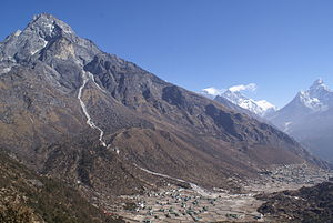
Khumjung (Nepali: खुम्जुंग) is a village in Khumbu Pasanglhamu rural municipality of Solukhumbu District in Province No. 1 of north-eastern Nepal. It is located in the Khumbu sub-region inside Sagarmatha National Park, a world heritage site. The village lies at an elevation of 3,790 metres above sea level, near Mount Khumbila.
A monastery in Khumjung has a purported Yeti scalp. This village has modern communications such as the Internet and mobile and landline phones.
The village is the seat of ward no. 4, which include Kunde, Khumjung, Tengboche (Tyangboche), Pangboche, Pheriche, Dole, Chharchung, Machhermo, Lobuche, Dingboche, and Gokyo. As of 2011, it had a population of 1,912 people living in 551 individual households.[1]
Khumjung school was built by Sir Edmund Hillary's Himalayan Trust in 1961. The school began with two classrooms but now caters to pre-school, primary and secondary sections with over 350 students.[2]
^"National Population and Housing Census 2011". Village Development Committee/Municipality. Government of Nepal. Archived from the original (PDF) on 2008-10-12. Retrieved 2018-05-18.
^Ryōhei Uchida (1991), Trekking Mount Everest, San Francisco Chronicle Books, ISBN 978-0-87701-884-1 page 51
municipality. Khumjung village Khumjung village and Mount Khumbila Khumjung village Purported Yeti scalp at Khumjung monastery VDC Khumjung - Villages and...
It includes the town of Namche Bazaar as well as the villages of Thame, Khumjung, Pangboche, Pheriche and Kunde. The famous Buddhist monastery at Tengboche...
Pangboche or Panboche is a village in Khumjung Village Development Committee of Solukhumbu District in Province No. 1 of Nepal at an altitude of 13,074...
Limit. He has reached the summit of Mount Everest 21 times. He lives in Khumjung, Nepal. In the first season of the Discovery Channel series (2006), he...
evidence of the Yeti. Hillary borrowed a supposed Yeti scalp from the Khumjung monastery then himself and Khumjo Chumbi (the village headman), brought...
school in his village of Khumjung. When the village elders gave permission for the supposed 200-year-old Yeti scalp in the Khumjung Monastery to be taken...
municipalities (Gaunpalika) in Solukhumbu district of Province No. 1 of Nepal. Khumjung, Namche & Jubing (1,5,7–9 No. Wards of Jubing) and Chaurikharka were incorporated...
Mount Everest, the highest point in Nepal and on Earth, is located in Khumjung of Solukhumbu District in the same province No. 1. "Geography – Nepal Embassy...
95444; 86.69528 Country Nepal Zone Sagarmatha Zone District Solukhumbu District VDC Khumjung Elevation 4,750 m (15,580 ft) Time zone UTC+5:45 (Nepal Time)...
encompassing the roadless town of Namche Bazaar and villages such as Thame, Khumjung, Pangboche, Pheriche and Kunde. The renowned Buddhist monastery at Tengboche...
Monastery), also known as Dawa Choling Gompa, in the Tengboche village in Khumjung in the Khumbu region of eastern Nepal is a Tibetan Buddhist monastery of...
Karnol, Sahebganj, India Died 9 May 2011(2011-05-09) (aged 82) Khumbu, Khumjung, Nepal Cause of death Exposure, AMS Occupation(s) Mountaineer, politician...
National Park Show map of Tibet Location Koshi, Nepal Nearest city Namche, Khumjung Coordinates 27°56′N 86°44′E / 27.933°N 86.733°E / 27.933; 86.733 Area...
m (25,938 ft) Traversed by A Swiss expedition in 1952 Location Nepal (Khumjung) – China (Tibet) Range Mahalangur Himal Coordinates 27°58′30″N 86°55′55...
Image and Public Record Office Victoria in Australia Lukla, Phakding, Khumjung, Phortse, Panboche, Dughla, Lobuche, Thamu, Thame and more location in...
0 sq mi) have been designated a Ramsar site. Gokyo Lakes are located in the Khumjung Village Development Committee of Solukhumbu District in the Sagarmatha...
92361; 86.78722 Country Nepal Zone Sagarmatha Zone District Solukhumbu District VDC Khumjung Elevation 4,620 m (15,160 ft) Time zone UTC+5:45 (Nepal Time)...
(2003 and 2008); two in Melbourne, Australia (2006 and 2010); one in Khumjung, Nepal (2011); two in Kathmandu, Nepal (2013 and 2017); and one in Ottawa...
 Global Information