 Global Information
Khirbat Ism Allah information
Khirbat Ism Allah
خربة إسم الله | |
|---|---|
Village | |
| Etymology: Kh. Ism Allah, the ruin of the name of God[1] | |
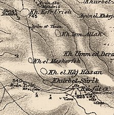 1870s map 1870s map 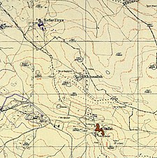 1940s map 1940s map modern map modern map 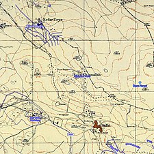 1940s with modern overlay map 1940s with modern overlay mapA series of historical maps of the area around Khirbat Ism Allah (click the buttons) | |
 Khirbat Ism Allah Location within Mandatory Palestine | |
| Coordinates: 31°46′59″N 34°57′19″E / 31.78306°N 34.95528°E | |
| Palestine grid | 145/132 |
| Geopolitical entity | Mandatory Palestine |
| Subdistrict | Jerusalem |
| Date of depopulation | July 17, 1948 |
| Area | |
| • Total | 568 dunams (56.8 ha or 140 acres) |
| Population (1945) | |
| • Total | 20[2][3] |
Khirbat Ism Allah was a Palestinian Arab hamlet in the Jerusalem Subdistrict, located 26 km west of Jerusalem. It was depopulated during the 1948 Arab–Israeli War on July 17, 1948, by the Harel Brigade of Operation Dani. Khirbat Ism Allah was mostly destroyed with the exception of several deserted houses.
- ^ Palmer, 1881, p. 306
- ^ Department of Statistics, 1945, p. 25
- ^ Government of Palestine, Department of Statistics. Village Statistics, April, 1945. Quoted in Hadawi, 1970, p. 57