The Kezi River (Chinese: 克孜河), also marked as Kirzl River (克孜勒河) and Kirzlesu River (克孜勒苏河) on the map of People's Republic of China, is a river in Xinjiang Uygur Autonomous Region[4] of China, located in Kizilsu Kyrgyz Autonomous Prefecture.[5]
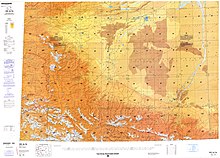
Map including K'o-tzu-le Ho (a name for the river; above 20⁴ on the map) (DMA, 1984)Map including Kizilsu He (a name for the river; near 15⁰ on the map) (DMA, 1989)
Kezi River originates from the Gora Kurumdy (Kurumdy I Summit) in Kyrgyzstan-Tajikistan border and enters Wuqia County in Xinjiang through the border at Simukhana Pass (斯木哈纳山口), which is the boundary between the Tianshan and Kunlun Mountains.[6] The river flows 900 kilometers within China,[7] with a drainage area of 15,100 square kilometers.
Kezi River is the largest river in the Kashgar water system.[8] In China, the river flows from west to east through Wuqia County, Kizilsu Kyrgyz Autonomous Prefecture, Shufu County, Shule County, Kashgar City, Jiashi City, and Bachu County in Kashgar Prefecture,[9] and finally meets the Yarkant River and joins the Tarim River basin.[10]
The Kashi segment (Xinjiang) of Kezi River was badly polluted.[11] In 2016, the control unit in the Kashgar Prefecture of the Kezi River was upgraded from worse than Grade V to Grade V.[12]
^"Changing characteristics of land use/cover and landscape pattern from 1990 to 2010 in the Kaxgar River basin, Xinjiang" (PDF). National Natural Science Foundation of China. 2014-12-13.
^"Schematic diagram of the earthquake zone in Bachu, Jiashi, Xinjiang". Xinhua News Agency. 2003-02-24. Archived from the original on June 27, 2003.
^"Kizilsu Kyrgyz Autonomous Prefecture of Xinjiang". State Ethnic Affairs Commission. 2004-07-13.
^"Soil and Water Loss Situation and Countermeasures in Downstream Area of Kezi River in Kaxgar River Basin of Xinjiang Wei Autonomous Region". August 13, 2004. S2CID 132615390. {{cite journal}}: Cite journal requires |journal= (help)
^"The song of happiness sings on the Pamir Mountains". Xinhua News Agency. Mar 5, 2006. Archived from the original on 2020-10-02.
^Karakoram: Physical Geography of the Kunlun Mountains Region. China Science Publishing & Media. 1999. ISBN 978-7-03-006933-7.
^"Kashgar pomegranate". Ministry of Commerce. Retrieved Oct 2, 2020.
^"100,000 artificially propagated fish fry released into the Kezi River". Sina News. Oct 23, 2018.
^Encyclopedia of China. Encyclopedia of China Publishing House. 1999. ISBN 9787500062127.
^Guan Shouxin; Liang Junyan; Zhang Wenya (2001). History of Kashgar Scenery. Yunnan People's Publishing House. ISBN 978-7-222-03202-6.
^"Report on the State of the Environment in China 2013" (PDF). Ministry of Ecology and Environment. 2016-06-21.
^"The 13th Five-Year Plan for the Protection of Ecological Environment" (PDF). Ministry of Ecology and Environment. 2017-06-23.
The KeziRiver (Chinese: 克孜河), also marked as Kirzl River (克孜勒河) and Kirzlesu River (克孜勒苏河) on the map of People's Republic of China, is a river in Xinjiang...
Kizilsu (also spelled Kezilesu, derived from Chinese pinyin) refers to the KeziRiver and means "red water" in the Kyrgyz language. Kiziloy, Kizilto, and the...
(70 mi) west of the Ulugqat (Wuqia) county seat on the southern bank of the KeziRiver. Simhama is considered to be the westernmost village of China, located...
bridges over the Mzingwane River: Bridge on Old Gwanda Road, between Matombo Mission and Blanket Mine. Bridge on Gwanda - Kezi road, below Thuli-Makwe Dam...
on the northern bank of the KeziRiver 35 km (22 mi) southwest of the county seat. There is a scrubland along the KeziRiver including many sea buckthorn...
Mwewe River is a tributary of the Thuli River in Matabeleland South Province.Its source is near Figtree town in Plumtree. It flows through Kezi business...
Archived from the original on 2007-09-27. Retrieved 2007-03-20. "Local News | KEZI". Archived from the original on 2011-07-13. Retrieved 2009-06-06. "Friends...
"Public asked to avoid Big Fall Creek Road due to Bedrock Fire activity". KEZI. Archived from the original on July 24, 2023. Retrieved July 24, 2023. "Bedrock...
Karakoram highway to the southwest are those of Kuk Sel (6,715 metres) and Kezi Sel (6,525 metres), about 5 km and 7 km south of the main summit. Kongur...
Sacred Heart Medical Center at RiverBend". U.S. News & World Report. Her, Chenue. "Riverbend Now Offers Pediatric Surgery". kezi.com. Retrieved 11 December...
village in the Kezi district in Zimbabwe. It stretches from the Mazakela River near Mabonyane Shopping Center up to Mhabhinyane river in the south. The...
located in the west of the national park, north of the game park on the Kezi-Bulawayo road. The frieze includes elephants, giraffes, warthogs, tsessebe...
Retrieved 15 September 2012. Her, Chenue. "Springfield Movie Theater Closing". KEZI. Retrieved 29 September 2014. Hall, Christian (December 7, 2015). "The Shoppes...
Commissioners Opposed to Renaming the Beltline". KEZI. "New Randy Pape Beltline Signs on the Way". KEZI. April 28, 2010. Archived from the original on October...
then-owners of Eugene's ABC affiliate KEZI (channel 9). The intention was to make KVDO a full-power satellite of KEZI. During the sale, KATU (channel 2)...
Maphisa. Maphisa is located about 110 km south of Bulawayo and 10 km south of Kezi, Maphisa is also located 66 km from the Province's Capital Gwanda but due...
Ursini, Nick. "Oregon State Improves to 3-0 with a win over Montana State". KEZI. Retrieved 3 August 2023. Martin, Spencer. "Montana State falls to Oregon...
southbound Willamette River Bridge opens two months ahead of schedule". Oregon.gov. August 24, 2011. "Willamette Passage Bridge Opens". KEZI.com. August 8, 2013...
 Global Information