Keowee (Cherokee: ᎫᏩᎯᏱ, romanized: Guwahiyi) was a Cherokee town in the far northwest corner of present-day South Carolina. It was the principal town of what were called the seven Lower Towns, located along the Keowee River (Colonists referred to the lower reaches of the river as the Savannah in its lower reaches, with its mouth at the city they named Savannah). Keowee was situated on the Lower Cherokee Traders' Path, part of the Upper Road through the Piedmont. In 1752 the Cherokee established New Keowee Town nearby, off the traders' path but in a more defensible location.
Both historic sites are within present-day Oconee County, South Carolina at the foot of the Blue Ridge Mountains. European Americans developed the town of Clemson, South Carolina, south of here after they began to populate the area.
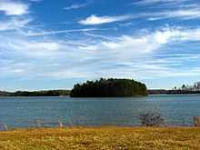
When the Keowee River was dammed in a mid-20th century hydropower project, both former Keowee sites were submerged in the early 1970s beneath the waters of Lake Keowee.[1][2] Before that, archeological excavation was conducted by specialists from the University of South Carolina to establish history and recover thousands of artifacts. Human and animal remains were also discovered at the site.[3]
^"Anderson-Oconee-Pickens County SC Historical Roadside Markers". Archived from the original on 2008-05-30. Retrieved 2007-07-15.
Lake Keowee is a man-made reservoir in the United States in the state of South Carolina. It was developed to serve the needs of power utility Duke Energy...
Keowee (Cherokee: ᎫᏩᎯᏱ, romanized: Guwahiyi) was a Cherokee town in the far northwest corner of present-day South Carolina. It was the principal town of...
Dam. The Keowee River flows out of Lake Jocassee Dam and into Lake Keowee, a reservoir created by Keowee Dam and Little River Dam. The Keowee River flows...
from the beginning of Lake Keowee, which has overtaken the underlying Keowee River. On the southern border of Lake Keowee is the city of Seneca, developed...
Keowee River, including: the major towns of Seneca and Keowee New Towne; as well as, Cheowie, Cowee, Coweeshee, Echoee, Elejoy, Estatoie, Old Keowee,...
Jocassee Dam (often called Lake Jocassee Dam) is an embankment dam on the Keowee River, straddling the border of Pickens and Oconee counties in South Carolina...
The Oconee Nuclear Station is a nuclear power station located on Lake Keowee near Seneca, South Carolina, and has a power output capacity of over 2,500 megawatts...
by Ostenaco, one of the leading men in the town, who was visiting from Keowee. After spending several days in Tomotley as guests of Ostenaco, Timberlake...
Esseneca, and Sinica) was a Cherokee town on the Keowee River. It was on the west side of the Keowee River, near the mouth of Coneross Creek, in today's...
Brown Lake Greenwood Lake Hartwell Lake Jocassee John D. Long Lake Lake Keowee Lake Marion Monticello Reservoir Lake Moultrie Lake Murray Parr Reservoir...
2 km) up the Little River to the Newry site; and 7 miles (11 km) up the Keowee to the Old Pickens site. The reservoir would cover 56,500 acres (22,900 ha)...
The Cherokee Path (or Keowee path) was the primary route of English and Scots traders from Charleston to Columbia, South Carolina in Colonial America....
Highway 11 enters northern Pickens County, where bridges carry it over Lake Keowee and it passes near Table Rock State Park before it leaves the county. Next...
Keowee River (called the Savannah River in its lower portion). The principal town of the Lower Towns was Keowee. Other Cherokee towns on the Keowee River...
by Col. Benjamin Hawkins, Gen. Andrew Pickens and Headman McIntosh, in Keowee, South Carolina in 1795 established the boundary of the Cherokee Nation...
River Savannah River Stevens Creek Little River Rocky River Seneca River Keowee River Little River Flat Shoals River Toxaway River Horsepasture River Whitewater...
 Global Information