Global Information Lookup Global Information

Kennet and Lambourn Floodplain information


Kennet and Lambourn Floodplain
Site of Special Scientific Interest
Rack Marsh
Kennet and Lambourn Floodplain is located in Berkshire
Kennet and Lambourn Floodplain
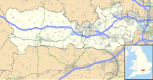
Location within Berkshire
LocationBerkshire
Wiltshire
Grid referenceSU 370 691[1]
Coordinates51°25′12″N 1°28′08″W / 51.420°N 1.469°W / 51.420; -1.469
InterestBiological
Area23.4 hectares (58 acres)[1]
Notification1996[1]
Location mapMagic Map

Kennet and Lambourn Floodplain is a 23.4-hectare (58-acre) biological Site of Special Scientific Interest in six widely separated areas in the floodplains of the River Lambourn in Berkshire and the River Kennet in Wiltshire, England.[1][2] It is a Nature Conservation Review site[1] and part of the Kennet and Lambourn Floodplain Special Area of Conservation.[3] One of the areas, Rack Marsh, is managed by the Berkshire, Buckinghamshire and Oxfordshire Wildlife Trust.[4]

These six areas all have fen or swamp with large numbers of Desmoulin's whorl snail, which is listed in the British Red Data Book as it is a nationally rare and declining species. One of the areas, Eddington Marsh, also has unimproved species-rich grassland with several nationally scarce invertebrates, such as the flies Pherbellia griseola, Psacadina verbekei, Platypalpus niger and Oxycera morrisi.[5]

  1. ^ a b c d e "Designated Sites View: Kennet and Lambourn Floodplain". Sites of Special Scientific Interest. Natural England. Retrieved 17 February 2020.
  2. ^ "Map of Kennet and Lambourn Floodplain". Sites of Special Scientific Interest. Natural England. Retrieved 17 February 2020.
  3. ^ "Designated Sites View: Kennet & Lambourn Floodplain". Special Areas of Conservation. Natural England. Retrieved 4 October 2019.
  4. ^ "Rack Marsh". Berkshire, Buckinghamshire and Oxfordshire Wildlife Trust. Retrieved 4 October 2019.
  5. ^ "Kennet and Lambourn Floodplain citation" (PDF). Sites of Special Scientific Interest. Natural England. Retrieved 17 February 2020.

and 13 Related for: Kennet and Lambourn Floodplain information

Request time (Page generated in 0.7889 seconds.)

Kennet and Lambourn Floodplain

Last Update:

Kennet and Lambourn Floodplain is a 23.4-hectare (58-acre) biological Site of Special Scientific Interest in six widely separated areas in the floodplains...

Word Count : 393

Bagnor

Last Update:

and the West End. Rack Marsh is a small local nature reserve in the village which is managed by BBOWT. As part of the Kennet and Lambourn floodplain it...

Word Count : 878

Kennet and Avon Canal

Last Update:

separate small areas, four in the Kennet Valley and three in the Lambourn Valley, which make up the Kennet and Lambourn Floodplain SSSI. Occupying a total of...

Word Count : 10320

Rack Marsh

Last Update:

Buckinghamshire and Oxfordshire Wildlife Trust. It is part of Kennet and Lambourn Floodplain, which is a Biological Site of Special Scientific Interest, and a Nature...

Word Count : 419

Thames Basin Heaths

Last Update:

Frensham Commons, Ash, Pirbright and Chobham SAC; Kennet Valley Alderwoods SAC; and Kennet and Lambourn Floodplain SAC Three national nature reserves: Chobham...

Word Count : 459

List of Special Areas of Conservation in England

Last Update:

Studland Cliffs Isle of Wight Downs Isles of Scilly Complex Kennet and Lambourn Floodplain Kennet Valley Alderwoods Kingley Vale Kirk Deighton Lake District...

Word Count : 752

List of Sites of Special Scientific Interest in Wiltshire

Last Update:

just 21 due to their geological interest (and 5 for both). Natural England took over the role of designating and managing SSSIs from English Nature in October...

Word Count : 323

List of Sites of Special Scientific Interest in Berkshire

Last Update:

England. Retrieved 15 September 2019. "Designated Sites View: Kennet & Lambourn Floodplain". Special Areas of Conservation. Natural England. Retrieved 4...

Word Count : 4124

Oxfordshire

Last Update:

3″W / 51.4596500°N 0.946750°W / 51.4596500; -0.946750, near Thames and Kennet Marina, Playhatch Westernmost point: 51°46′59.73″N 1°43′9.68″W / 51...

Word Count : 2326

Boxford Water Meadows

Last Update:

Berkshire. It is part of the Kennet & Lambourn Floodplain Special Area of Conservation. The site comprises disused water meadows and flood pastures in the valley...

Word Count : 160

Thatcham Reed Beds

Last Update:

of Newbury in Berkshire. It is part of the Kennet & Lambourn Floodplain Special Area of Conservation and an area of 14 hectares (35 acres) is a Local...

Word Count : 295

Chalk stream

Last Update:

Frome River Itchen and its small tributaries River Kennet River Lambourn River Loddon Letcombe Brook River Meon River Piddle River Test and its tributaries...

Word Count : 1380

List of local nature reserves in Berkshire

Last Update:

and Oxfordshire Wildlife Trust. Archived from the original on 8 October 2019. Retrieved 16 September 2019. "Designated Sites View: Kennet & Lambourn Floodplain"...

Word Count : 1535

PDF Search Engine © AllGlobal.net