Volcano eruption at Fagradalsfjall next to Litli-Hrútur and with Keilir in the backgroundKeilir from Spákonuvatn lake, Reykjavegur hiking trailRemote view of Keilir among tumuli within Hvassahraun lava field (Krýsuvík volcanic system
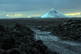
Keilir (Icelandic pronunciation:[ˈcʰeiːlɪr̥]; 378 m asl) is a Pleistocene subglacial mound or perhaps a conical tuya[3] on Reykjanes Peninsula in Iceland.[4] Basal area is 0.773 km2, summit area 0.004 km2, basal width 0.99 km, summit width 0.07 km, volume 0.0362 km3.[3]
It is located within the area of Krýsuvík volcanic system[5] and Reykjanesfólkvangur. It is about 17 miles southwest of the capital city Reykjavík,
In March 2021 the mountain began to emit earthquakes followed by a fissure lava eruption further southwest at Fagradalsfjall.
^Ari Trausti Guðmundsson, Pétur Þorsteinsson: Íslensk fjöll. Gönguleiðir á 152 tind. Reykjavík 2004, p. 156
^G.B.M.Pedersen, P. Grosse: Morphometry of subaerial shield volcanoes and glaciovolcanoes from Reykjanes Peninsula, Iceland: Effects of eruption environment. Journal of Volcanology and Geothermal Research 282, (2014), 115-133. Retrieved 17 August 2020.
^ abG.B.M.Pedersen, P. Grosse: Morphometry of subaerial shield volcanoes and glaciovolcanoes from Reykjanes Peninsula, Iceland: Effects of eruption environment. Journal of Volcanology and Geothermal Research 282, (2014), 115-133. See also for maps therein.
^Íslandshandbókin. Náttúra, saga og sérkenni. Reykjavík 1989, p. 53
^See eg. maps herein: Ermias Yohannes Berhane: Geochemical interpretation of thermal water and gas samples from Krýsuvík, Iceland and Alid, Eritrea. The United Nations University. Report No. 18, 2004.
Keilir (Icelandic pronunciation: [ˈcʰeiːlɪr̥]; 378 m asl) is a Pleistocene subglacial mound or perhaps a conical tuya on Reykjanes Peninsula in Iceland...
other tertiary colleges. Both types are referred to as "háskóli" locally. Keilir REYST University Centre of the Westfjords United Nations University (selected...
Keilir Golf Club is a golf club and course located in Hafnarfjördur, Iceland, on the Hvalreyi peninsula. Keilir Golf Club was established in 1967. It...
Hvannadalshnúkur (Highest peak) Hveravellir Hverfjall . Hotspot Ingólfsfjall Jólnir Katla Keilir Kerlingarfjöll Note: Kolbeinsey (3.84 km further north of map at 67deg)...
to 40 °C (100 to 104 °F). Snæfellsjökull (a glacier-capped volcano) and Keilir mountain are visible from Sky Lagoon. The spa is a competitor of the nearby...
taken by Icelandair to cope with the 2010 air travel disruptions" (PDF). Keilir.net. Archived from the original (PDF) on 23 March 2012. Retrieved 7 October...
country's largest research institution, has a programme in renewable energy Keilir, Atlantic center of excellence in Ásbrú, runs a research center in energy...
in length, stretched for over 1 km (0.62 mi) between Fagradalsfjall and Keilir, significantly longer than the Meradalir eruptions. Flow of lava up to 50 m3...
Light Iceland Open is held jointly at Reykjavik Golf Club as well as at Keilir Golf Club during the summer solstice at the end of June each year since...
of golf courses in Iceland. Álftaness Golf Club Brautarholts Golf Club Keilir Golf Club Kópavogs/Garðabæjar Golf Club Mosfellsbæjar Golf Club Oddur Golf...
 Global Information