Global Information Lookup Global Information

Kediet ej Jill information


Kediet ej Jill
كدية الجل
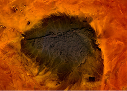
Mt. Kediet ej Jill, Mauritania - seen from space
Highest point
Elevation915 m (3,002 ft)
Prominence596 m (1,955 ft)
ListingCountry high point
Coordinates22°39′04″N 12°34′27″W / 22.65111°N 12.57417°W / 22.65111; -12.57417
Geography
Kediet ej Jill كدية الجل is located in Mauritania
Kediet ej Jill كدية الجل
Kediet ej Jill
كدية الجل
Location of Kediet ej Jill in Mauritania
LocationMauritania

Kediet ej Jill (Arabic: كدية الجل) is a mountain in Tiris Zemmour, Mauritania, with the city of Zouérat on its east and Fderick at west. At 915 m (3,002 ft) tall, Kediet ej Jill includes the highest peak in Mauritania.

The mountain and its surrounding area are rich in iron deposits, thought to have been mined here since the 11th century and commercially exploited since 1952. The current mines are connected to Nouadhibou on the Atlantic coast by a 700-km long railway.[1]

The mountain appears bluish because of the high concentration of magnetite, an iron ore and a natural magnet.[2] Owing to its inherent magnetic properties, the mountain disrupts navigational compasses. Similar magnetic fields allowed the discovery of other deposits in the region (magnetite guelbs) in the 1960s.

  1. ^ SNIM, Mauritania, www.mining-technology.com (access: January 25 2017)
  2. ^ European Space Agency, esa.int (access: August 2 2020)

and 7 Related for: Kediet ej Jill information

Request time (Page generated in 0.7936 seconds.)

Kediet ej Jill

Last Update:

Kediet ej Jill (Arabic: كدية الجل) is a mountain in Tiris Zemmour, Mauritania, with the city of Zouérat on its east and Fderick at west. At 915 m (3,002 ft)...

Word Count : 163

Magnetite

Last Update:

Wales; and in the Adirondack Mountains of New York in the United States. Kediet ej Jill, the highest mountain of Mauritania, is made entirely of the mineral...

Word Count : 5368

Mauritania

Last Update:

Guelb er Richat is a prominent feature of the north-central region. Kediet ej Jill, near the city of Zouîrât, has an elevation of 915 metres (3,000 ft)...

Word Count : 9300

Geography of Mauritania

Last Update:

Guelb er Richat is a prominent feature of the north-central region. Kediet ej Jill, near the city of Zouîrât, has an elevation of 915 metres or 3,002 feet...

Word Count : 2694

List of elevation extremes by country

Last Update:

1397 m 4,583 ft Caribbean Sea sea level 1397 m 4,583 ft  Mauritania Kediet ej Jill 915 m 3,002 ft Sebkha de Ndrhamcha −5 m −16 ft 920 m 3,018 ft  Mauritius...

Word Count : 2029

Outline of Mauritania

Last Update:

Coordinated Universal Time UTC+00 Extreme points of Mauritania High: Kediet ej Jill 915 m (3,002 ft) Low: Sebkha de Ndrhamcha −5 m (−16 ft) Land boundaries:...

Word Count : 644

List of highest points of African countries

Last Update:

(9,849 ft) 43  Mali Hombori Tondo 1,155 m (3,789 ft) 47  Mauritania Kediet ej Jill 915 m (3,002 ft) 50  Mauritius Piton de la Petite Rivière Noire 828 m...

Word Count : 457

PDF Search Engine © AllGlobal.net