Lake and Peninsula, Kodiak Island, Kenai Peninsula, and Bristol Bay boroughs, Alaska, United States
Nearest city
King Salmon
Coordinates
58°30′N155°00′W / 58.5°N 155°W / 58.5; -155
Area
4,093,077 acres (16,564.09 km2)[2]
Established
December 2, 1980
Visitors
37,818 (in 2015 – latest count)[3]
Governing body
National Park Service
Website
Katmai National Park & Preserve
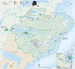
class=notpageimage|
Map of Katmai National Park and Preserve
class=notpageimage|
Map of Katmai National Park and surrounding area
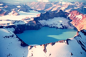
Katmai National Park and Preserve is an American national park and preserve in southwest Alaska, notable for the Valley of Ten Thousand Smokes and for its brown bears. The park and preserve encompass 4,093,077 acres (6,395.43 sq mi; 16,564.09 km2), which is between the sizes of Connecticut and New Jersey. Most of the national park is a designated wilderness area. The park is named after Mount Katmai, its centerpiece stratovolcano. The park is located on the Alaska Peninsula, across from Kodiak Island, with headquarters in nearby King Salmon, about 290 miles (470 km) southwest of Anchorage. The area was first designated a national monument in 1918 to protect the area around the major 1912 volcanic eruption of Novarupta, which formed the Valley of Ten Thousand Smokes, a 40-square-mile (100 km2), 100-to-700-foot-deep (30 to 213 m) pyroclastic flow. The park includes as many as 18 individual volcanoes, seven of which have been active since 1900.
Initially designated because of its volcanic history, the monument was left undeveloped and largely unvisited until the 1950s. The monument and surrounding lands became appreciated for their wide variety of wildlife, including an abundance of sockeye salmon and the brown bears that feed upon them. After a series of boundary expansions, the present national park and preserve were established in 1980 under the Alaska National Interest Lands Conservation Act.
^"Protected Area Profile for Katmai from the World Database of Protected Areas". protectedplanet.net. UN World Conservation Monitoring Centre and the IUCN. Retrieved September 7, 2021.
^"Listing of acreage – December 31, 2011" (XLSX). Land Resource Division, National Park Service. Retrieved March 7, 2012. (National Park Service Acreage Reports)
^"NPS Annual Recreation Visits Report". National Park Service. Retrieved March 7, 2019.
and 26 Related for: Katmai National Park and Preserve information
the Alaska Peninsula in southern Alaska, located within Katmai NationalParkandPreserve. It is about 6.3 miles (10 km) in diameter with a central lake-filled...
on the Alaska Peninsula on a slope of Trident Volcano in KatmaiNationalParkandPreserve, about 290 miles (470 km) southwest of Anchorage. Formed during...
The Valley of Ten Thousand Smokes is a valley within KatmaiNationalParkandPreserve in Alaska which is filled with ash flow from the eruption of Novarupta...
October by KatmaiNationalParkandPreserve in Alaska, commemorating the impressive seasonal preparations made by brown bears inhabiting Katmai as they...
chronicles the life and death of bear enthusiast and conservationist Timothy Treadwell and his girlfriend Amie Huguenard at KatmaiNationalPark, Alaska. The...
Lake Clark NationalParkandPreserve is an American nationalpark in southwest Alaska, about 100 miles (160 km) southwest of Anchorage. The park was first...
in Katmai NationalParkandPreserve". NationalPark Service. Retrieved 6 July 2013. "KatmaiNationalParkandPreserve Webcams Make Katmai Bears Accessible...
Clark NationalPark, KatmaiNationalParkandPreserve, and other NationalPark Service and U.S. Fish and Wildlife Service units and Alaska local and state...
the Arctic NationalParkandPreserve is an American nationalpark that protects portions of the Brooks Range in northern Alaska. The park is the northernmost...
in KatmaiNationalParkandPreserve, the lake is 40 miles (64 km) long and three to eight miles (4.8 to 12.9 km) wide, the largest lake in the park. The...
Naknek lie at its mouth, on the north and south banks respectively. The head lies within KatmaiNationalParkandPreserve. List of rivers of Alaska "Naknek...
the National Register of Historic Places listings in KatmaiNationalParkandPreserve. This is intended to be a complete list of the properties and districts...
active stratovolcano located in the U.S. state of Alaska within KatmaiNationalPark & Preserve. The volcano is nearly completely covered by Fourpeaked Glacier...
is a stratovolcano located in the northeastern part of the KatmaiNationalParkandPreserve in the U.S. state of Alaska. The 2.5 kilometres (1.6 mi) wide...
stratovolcano, located on the Alaska Peninsula, United States, in KatmaiNationalParkandPreserve. It is the oldest of the volcanoes in the vicinity of the...
Volcano is an eroded volcanic complex on the Alaska Peninsula in KatmaiNationalPark, Alaska. Up to 23 domes comprise the complex stratovolcano, with...
located within KatmaiNationalParkandPreserve in Alaska. Located on the Brooks River a mile and a half (2.4 km) from Brooks Lake and an equal distance...
Glacier Bay NationalParkandPreserve is an American nationalpark located in Southeast Alaska west of Juneau. President Calvin Coolidge proclaimed the...
Brooks Camp is a visitor attraction and archeological site in KatmaiNationalParkandPreserve, noted for its opportunities for visitors to observe Alaskan...
historic boathouse at Brooks Camp, a major visitor site in KatmaiNationalParkandPreserve, located on the Alaska Peninsula of southwestern Alaska. The...
 Global Information