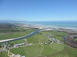
Karamea is a town on the West Coast of the South Island of New Zealand. It is the northernmost settlement of any real size on the West Coast, and is located 96 kilometres (60 mi) northeast by road from Westport. Apart from a narrow coastal strip, the town of Karamea and its local area are completely surrounded to the south, east and north by Kahurangi National Park.
The town is located on the coastal plain adjacent to the Karamea River and the Ōtūmahana Estuary. The town consists of two small settlements, Market Cross and Karamea proper, located about 1 kilometre (0.62 mi) apart. Up the Karamea River are the farming areas of Arapito (on the south bank) and Umere (on the north bank).
Karamea is a gateway to the Kahurangi National Park, and provides a base for visitors coming to walk or mountain bike the Heaphy Track, or see popular local attractions such as the Ōpārara Basin, Ōpārara Arches, the Fenian Track and caves, the Big Rimu Walk and the coastal scenery north of Kōhaihai on the Heaphy Track.
^Cite error: The named reference Area was invoked but never defined (see the help page).
^"Subnational population estimates (RC, SA2), by age and sex, at 30 June 1996-2023 (2023 boundaries)". Statistics New Zealand. Retrieved 25 October 2023. (regional councils); "Subnational population estimates (TA, SA2), by age and sex, at 30 June 1996-2023 (2023 boundaries)". Statistics New Zealand. Retrieved 25 October 2023. (territorial authorities); "Subnational population estimates (urban rural), by age and sex, at 30 June 1996-2023 (2023 boundaries)". Statistics New Zealand. Retrieved 25 October 2023. (urban areas)
Karamea is a town on the West Coast of the South Island of New Zealand. It is the northernmost settlement of any real size on the West Coast, and is located...
The Karamea Bight is the name given to a large bay in the Tasman Sea formed by a curved stretch of the West Coast of New Zealand's South Island. It stretches...
The Karamea Aerodrome serves the town of Karamea, in the South Island of New Zealand. It is a non certificated aerodrome located around 1.4 kilometres...
The Karamea River is located in the West Coast Region of the South Island of New Zealand. The river rises within Kahurangi National Park in the Matiri...
Karamea Centennial Museum is a museum in Karamea on the West Coast of the South Island of New Zealand. The museum was opened in 1974, for the centennial...
the Karamea River, the Leslie flows west from the Wharepapa / Arthur Range, meeting the Karamea 28 kilometres (17 mi) east of the town of Karamea. The...
two kilometres before the latter flows into the Karamea River, 17 kilometres to the east of Karamea. List of rivers of New Zealand "Place name detail:...
town in the Karamea area of New Zealand. Umere is a farming community on the north side of the Karamea River, upriver from the main Karamea township. The...
Zealand's South Island. It flows south to reach the Karamea River 17 kilometres northeast of Karamea. The river's entire length is within Kahurangi National...
September each year. The southern end of the track is at Kōhaihai, north of Karamea on the northern West Coast, and the northern end is in the upper valley...
Laniatores. The subfamily includes four genera: Sorensenella Pocock, 1903 and Karamea Forster, 1954 from New Zealand, and Roeweria Lawrence, 1931 (now Lawrencella...
Karamea War Memorial Library, also known as Karamea Community Library, is a community public library located in the settlement of Karamea in the West...
Tsunamis affecting New Zealand are mainly due to the country being part of the geologically active Pacific Plate and associated with the Pacific Ring of...
three light aircraft from Tākaka to Wellington and Karamea, and also from Nelson to Tākaka and Karamea with connecting road shuttle services to the Abel...
subfamily Sorensenellinae to accommodate Sorensenella Pocock, 1903 and Karamea Forster, 1954 from New Zealand, and Roeweria Lawrence, 1931 (now Lawrencella...
Haast Hanmer Springs Hari Hari Havelock Hokitika Invercargill Kaikōura Karamea Leeston Lincoln Lumsden Māpua Mataura Milton Motueka Murchison Nelson Oamaru...
boundary of the two. Along the West Coast the various intrusions include the Karamea Granite and the Rahu, Separation Point and Darran suites. These intrusions...
gradually turning southwest before reaching the Karamea River 25 kilometres (16 mi) east of Karamea. List of rivers of New Zealand "Place name detail:...
 Global Information