 Global Information
Kangxiwar information
Kangxiwar | |
|---|---|
 Kangxiwar memorial signage | |
 Kangxiwar | |
| Coordinates: 36°12′20″N 78°45′45″E / 36.20556°N 78.76250°E | |
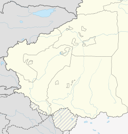
| Country | China |
| Region | Xinjiang |
| Prefecture | Hotan Prefecture |
| County | Pishan County |
| Township | Xaidulla |
| Elevation [1] | 4,000 m (13,000 ft) |
| Kangxiwar | |||||||
|---|---|---|---|---|---|---|---|
| Chinese name | |||||||
| Traditional Chinese | 康西瓦 | ||||||
| Simplified Chinese | 康西瓦 | ||||||
| |||||||
| Uyghur name | |||||||
| Uyghur | كەڭشىۋەر | ||||||
| |||||||
Kangxiwar (Chinese: 康西瓦; pinyin: Kāng xī wǎ; Uyghur: كەڭشىۋەر)[a] is the location of a deserted town on the southwest side of the Kunlun Mountains. It is on the bank of the Karakash River in the western Xinjiang Uyghur Autonomous Region of the People's Republic of China. It is also the base of the route to Hotan from the Karakash valley via the Hindutash pass. According to Chinese sources, Kangxiwar means "place with mine" in Uyghur.[5]
During the Sino-Indian War of 1962, Kangxiwar served as the forward headquarters for the Xinjiang Military Command. The military cemetery of those killed in the war is still located here. There is also a highway maintenance crew house at Kangxiwar at the present time.[6] China National Highway 219 (G219), the Xinjiang-Tibet Highway, runs through here.[5] Following the G219 southeast will lead to Dahongliutan and Tianshuihai,[6] the latter of which is in Aksai Chin. China National Highway 580 is under construction connecting Kangxiwar directly with Hotan.[7] It is scheduled to be completed in 2022.[8][needs update]
Kangxiwar Daban[6] or Koshbel Pass[9][10] (lit. '"twin pass"'[11]) is a mountain pass located at the elevation of 4,250 metres (13,940 ft) downstream to the west.
- ^ Du Zheng; Qingsong Zhang; Shaohong Wu (2000). Mountain Geoecology and Sustainable Development of the Tibetan Plateau. Springer Science & Business Media. p. 352. ISBN 978-0-7923-6688-1.
Kangxiwar at an elevation of about 4000m asl has a precipitation of only 36.6 mm.
- ^ Cite error: The named reference
VisserVisser-Hooft1935was invoked but never defined (see the help page). - ^ Sandhu, Shankar & Dwivedi 2015, p. 46.
- ^ Sandhu, Shankar & Dwivedi 2015, p. 40.
- ^ a b 国际展望 (Guoji Zhanwang / World Outlook Magazine) (21 March 2005). "专访中国海拔最高的烈士陵园" (in Chinese). Sina Military News. Archived from the original on 1 December 2010. Retrieved 7 January 2020.
这就是被称为"新藏线"的219国道。在219国道的新疆段,人们可以很容易地找到一个以居民地形式标识的地形点——康西瓦。康西瓦,维语的意思是"有矿的地方"。
- ^ a b c "45 Days Ride along Dragon's Backbone: Kashgar to Lhasa". TibetTour.org. Archived from the original on 30 December 2019. Retrieved 7 January 2020.
The milestone 425.5 marks Kangxiwa Daban which is 4250M-high. Ride down hard against the wind. When wading across two small rivers near to the interjection of Kangwaxi Revolutionary Martyrs Cemetery, you get to the destination today- the Kangxiwa High-way Keepers' House. ... Reach the Hongliutan ... ride to Tianshuihai Army Service Station
- ^ Zeng, Tao-rui; Wang, Lin-feng (2019). "The Reliability and Stability Analysis of High Shear Slope in Cold Region Based on First Order Quadratic Matrix". Science Technology and Engineering (21). kns.ccpd.cnki.net. ISSN 1671-1815. Retrieved 7 January 2020.
Taking the K86 + 780 ~ K86 + 840 soil high cut slope of the highway section from Hetian to Kangxiwa of G580 line as an example,the reliability calculation of soil high cut slope in the cold region was carried out
[permanent dead link] - ^ 中国交通新闻网 (18 November 2019). "580国道和康项目一标完成路面摊铺" [G580 Hotan-Kangxiwar Project first milestone completed, road surface paved]. Ministry of Transport of the People's Republic of China. Retrieved 7 January 2020.
日前,580国道新疆和田至康西瓦公路项目一标主线沥青路面完成摊铺,为2022年全线通车奠定了坚实基础。
- ^ Lonely Planet; Stephen Lioy; Bradley Mayhew; Megan Eaves (1 May 2019). Lonely Planet Tibet. Lonely Planet Global Limited. p. 311. ISBN 978-1-78868-583-2. Archived from the original on 28 October 2020. Retrieved 18 April 2020.
The road climbs again over the 4250m Koshbel Pass to the truck stop of Dahongliutan (4200m), which offers basic food and lodging.
- ^ "Koshbel Duban". dangerousroads.org. Archived from the original on 28 October 2020. Retrieved 16 January 2020.
- ^ Sven Anders Hedin; Nils Peter Ambolt (1967). Central Asia Atlas, Memoir on Maps: Index of geographical names, by D.M. Farquhar, G. Jarring and E. Norin. Sven Hedin Foundation, Statens etnografiska museum. p. 49. Archived from the original on 28 October 2020. Retrieved 18 April 2020.
'twin pass' ... Koshbel Dawan (of Kengshewar)
Cite error: There are <ref group=lower-alpha> tags or {{efn}} templates on this page, but the references will not show without a {{reflist|group=lower-alpha}} template or {{notelist}} template (see the help page).