 Global Information
Kandarawadi information
| Kantarawadi (Eastern Karenni) ကန္ဒရဝတီ | |||||||||
|---|---|---|---|---|---|---|---|---|---|
| Princely State of the Karenni States | |||||||||
| 18th century–1959 | |||||||||
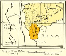 1917 map of the Karenni States | |||||||||
| Area | |||||||||
• 1931 | 6,475 km2 (2,500 sq mi) | ||||||||
| Population | |||||||||
• 1931 | 30,677 | ||||||||
| • Type | Monarchy | ||||||||
| History | |||||||||
• Independence | 18th century | ||||||||
• Abdication of the Kayah rulers | 1959 | ||||||||
| |||||||||


Kantarawadi (Burmese: ကန္ဒရဝတီ; Thai: กันตรวดี), also known as Gantarawadi,[1] was one of the Karenni States in what is today Kayah State in Burma. It was also known as "Eastern Karenni" owing to the location of part of its territory east of the Salween River.[2]
- ^ Cite error: The named reference
IGIwas invoked but never defined (see the help page). - ^ Khu Oo Reh (October 2006). "Highlights in Karenni History to 1948". Retrieved 19 December 2010.