Global Information Lookup Global Information

Kanawha River information


Kanawha River
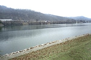
The Kanawha River in St. Albans, West Virginia
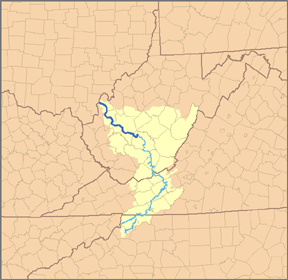
Map of the Kanawha River and its tributary the New River, with the Kanawha River highlighted in darker blue.
Location
CountryUnited States
StateWest Virginia
CountiesFayette, Kanawha, Putnam, Mason
Physical characteristics
SourceNew River
 • locationAshe County, NC
 • coordinates36°32′45″N 81°21′09″W / 36.54583°N 81.35250°W / 36.54583; -81.35250
 • elevation2,546 ft (776 m)
2nd sourceGauley River
 • locationThree Forks of Gauley, Pocahontas County, WV
 • coordinates38°24′33″N 80°14′17″W / 38.40917°N 80.23806°W / 38.40917; -80.23806
 • elevation2,917 ft (889 m)
Source confluence 
 • locationGauley Bridge, WV
 • coordinates38°09′42″N 81°11′47″W / 38.16167°N 81.19639°W / 38.16167; -81.19639
 • elevation653 ft (199 m)
MouthOhio River[1]
 • location
Point Pleasant, WV
 • coordinates
38°50′16″N 82°08′34″W / 38.83778°N 82.14278°W / 38.83778; -82.14278
 • elevation
538 ft (164 m)
Length97 mi (156 km)
Basin size12,236 sq mi (31,690 km2)
Discharge 
 • locationCharleston, 56.8 mi (91.4 km) from the mouth[2][3]
 • average15,240 cu ft/s (432 m3/s)
 • minimum1,100 cu ft/s (31 m3/s)
 • maximum216,000 cu ft/s (6,100 m3/s)
Basin features
ProgressionKanawha River → Ohio River → Mississippi River → Gulf of Mexico
Tributaries 
 • leftFerry Branch, Coal River
 • rightElk River, Pocatalico River

The Kanawha River (/kəˈnɔːə/ kə-NAW) is a tributary of the Ohio River, approximately 97 mi (156 km) long, in the U.S. state of West Virginia. The largest inland waterway in West Virginia, its watershed has been a significant industrial region of the state since early in the 19th century.

It is formed at the town of Gauley Bridge in northwestern Fayette County, approximately 35 mi (56 km) SE of Charleston, by the confluence of the New and Gauley rivers 2 mi upstream from Kanawha Falls. The waterfall is 24 ft high and has been a barrier to fish movement for more than 1 million years.[4]: 13  The river flows generally northwest, in a winding course on the unglaciated Allegheny Plateau, through Fayette, Kanawha, Putnam, and Mason counties, past the cities of Charleston and St. Albans, and numerous smaller communities. It joins the Ohio at Point Pleasant. An environmental overview and summary of natural and human factors affecting water quality in the watershed was published in 2000.[5]

Paleo-Indians, the earliest indigenous peoples, lived in the valley and the heights by 10,000 BC as evidenced by archaeological artifacts such as Clovis points. A succession of prehistoric cultures developed, with the Adena culture beginning the construction of numerous skilled earthwork mounds and enclosures more than 2000 years ago. Some of the villages of the Fort Ancient culture survived into the times of European contact.

The area was a place of competition among historical American Indian nations. Invading from their base in present-day New York, the Iroquois drove out or conquered Fort Ancient culture peoples, as well as such tribes as the Huron and Conoy. By right of conquest, the Iroquois, Lenape (Delaware), and Shawnee reserved the area as a hunting ground. They resisted European-American settlement during the colonial years. Eventually the settlers took over by right of conquest.

  1. ^ U.S. Geological Survey Geographic Names Information System: Kanawha River
  2. ^ accessed 2011-06-16
  3. ^ United States Geological Survey; USGS 03193000 KANAWHA RIVER AT KANAWHA FALLS, WV; retrieved April 19, 2008.
  4. ^ Cite error: The named reference circ was invoked but never defined (see the help page).
  5. ^ Cite error: The named reference wri was invoked but never defined (see the help page).

and 20 Related for: Kanawha River information

Request time (Page generated in 0.8317 seconds.)

Kanawha River

Last Update:

The Kanawha River (/kəˈnɔːə/ kə-NAW-ə) is a tributary of the Ohio River, approximately 97 mi (156 km) long, in the U.S. state of West Virginia. The largest...

Word Count : 1783

James River and Kanawha Canal

Last Update:

The James River and Kanawha Canal was a partially built canal in Virginia intended to facilitate shipments of passengers and freight by water between...

Word Count : 2133

Little Kanawha River

Last Update:

The Little Kanawha River is a tributary of the Ohio River, 169 mi (269 km) long, in western West Virginia in the United States. Via the Ohio, it is part...

Word Count : 538

Kanawha

Last Update:

up Kanawha in Wiktionary, the free dictionary. Kanawha may refer to: Kanawha River in West Virginia, joining the Ohio River at Point Pleasant Kanawha Falls...

Word Count : 274

Teays River

Last Update:

represented by a network of river valleys. The largest still existing contributor to the former Teays River is the Kanawha River in West Virginia, which is...

Word Count : 2670

Ohio River

Last Update:

Little Kanawha River – Parkersburg, West Virginia Hocking River – Hockingport, Ohio Kanawha River – Point Pleasant, West Virginia Guyandotte River – Huntington...

Word Count : 8200

List of rivers of West Virginia

Last Update:

tributary) Kanawha River New River East River Indian Creek Bluestone River Little Bluestone River Brush Creek Greenbrier River East Fork Greenbrier River Little...

Word Count : 2024

Kanawha Valley Campaign of 1862

Last Update:

Kanawha Valley Campaign of 1862 was Confederate Major General William W. Loring's military campaign to drive the Union Army out of the Kanawha River Valley...

Word Count : 5616

James River

Last Update:

portion of the Kanawha River, a tributary of the Ohio River. For the most mountainous section between the two points, the James River and Kanawha Turnpike was...

Word Count : 2601

2014 Elk River chemical spill

Last Update:

released from a Freedom Industries facility into the Elk River, a tributary of the Kanawha River, in Charleston in the U.S. state of West Virginia. The...

Word Count : 5896

Kanawha Falls

Last Update:

81°12′44″W / 38.15278°N 81.21222°W / 38.15278; -81.21222 Kanawha Falls is a waterfall on the Kanawha River in West Virginia that has been a barrier to fish movement...

Word Count : 499

James River and Kanawha Turnpike

Last Update:

the western reaches of the James River via the James River and Kanawha Canal and the eastern reaches of the Kanawha River. Originally proposed by a young...

Word Count : 446

New River Gorge National Park and Preserve

Last Update:

Coast. The New River itself originates in North Carolina, flowing north through Virginia into the West Virginia mountains to the Kanawha River which continues...

Word Count : 1781

State of Kanawha

Last Update:

name of "Kanawha" was based on the prominence of the Kanawha River running through the area (itself named after the local Canawagh, or Kanawha, Indian...

Word Count : 590

Witcher

Last Update:

Witcher may refer to: Witcher (surname) Witcher Creek, a tributary of the Kanawha River in West Virginia, United States Witcher Holes Creek, a stream in the...

Word Count : 110

Battle of Point Pleasant

Last Update:

Battle of Point Pleasant, also known as the Battle of Kanawha and the Battle of Great Kanawha, was the only major action of Dunmore's War. It was fought...

Word Count : 1259

Gauley River

Last Update:

Gauley River is a 105-mile-long (169 km) river in West Virginia. It merges with the New River to form the Kanawha River, a tributary of the Ohio River. The...

Word Count : 644

Greenbrier River

Last Update:

Greenbrier River is a tributary of the New River, 162 miles (261 km) long, in southeastern West Virginia, in the United States. Via the New, Kanawha and Ohio...

Word Count : 1700

West Virginia

Last Update:

between the Kanawha and Little Kanawha Rivers. During the 1750s, when the Mingo Seneca seceded from the Iroquois and returned to the Ohio River Valley, they...

Word Count : 18018

Kanawha River Railroad

Last Update:

The Kanawha River Railroad (reporting mark KNWA) is a common-carrier railroad in the United States. A subsidiary of Watco, it leases 309 miles of track...

Word Count : 166

PDF Search Engine © AllGlobal.net