 Global Information
Kamyshlov Log information
Kamyshlov Log
Камышловский лог Камыстысай | |
|---|---|
Valley | |
 View of a stretch of the Kamyshlov Log in Maryanovsky District, Omsk Oblast | |
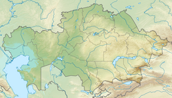 Kamyshlov Log Location  Kamyshlov Log Kamyshlov Log (Russia) | |
| Coordinates: 55°0′N 70°50′E / 55.000°N 70.833°E | |
| Location | Kazakhstan, Russia |
| Part of | West Siberian Plain |
| Dimensions | |
| • Length | 500 km (310 mi) |


The Kamyshlov Log (Russian: Камышловский лог or Урочище Камышловский лог; Kazakh: Камыстысай), is a former river valley of Siberia. Administratively it falls within Omsk Oblast, Siberian Federal District, of the Russian Federation, as well as the North Kazakhstan Region of Kazakhstan.[1][2]
The first geographical observations about the Kamyshlov Log in the early 18th century described it as a flowing river,[3] consisting in a chain of long lakes interconnected by channels, which seasonally dried up, but flowed again during periods of high water. However, by the 19th century most of the surrounding steppe was converted into agricultural fields and the flow between the lakes gradually stopped. The runoff along an almost imperceptible channel last took place in 1865 when the water reached the village of Poludino.[4]
- ^ Google Earth
- ^ Geographical position, geological structure and surface topography of the south of Western Siberia (in Russian)
- ^ Drawing Book of Siberia, compiled by Semyon Remezov 1701.
- ^ Cite error: The named reference
OOwas invoked but never defined (see the help page).