From left to right, top to bottom: Kamphaeng Phet Historical Park, Wat Chang Rob, Khlong Lan Waterfall, Wat Phra Bommathat, Wat Thung Sanun Rattanaram, Mae Wong National Park
Flag
Seal
Nickname(s):
Chakungrao (Thai: ชากังราว) Mueang Kluai Khai (city of lady finger bananas)
Motto(s):
กรุพระเครื่อง เมืองคนแกร่ง พระแสงฯ ล้ำค่า ศิลาแลงใหญ่ กล้วยไข่หวาน น้ำมันลานกระบือ เลื่องลือมรดกโลก ("Buddha amulets repository. City of the strong. Precious Phra Saeng swords. Large laterite slabs, Sweet lady finger bananas. Lan Krabue oil. Renowned world heritage.")
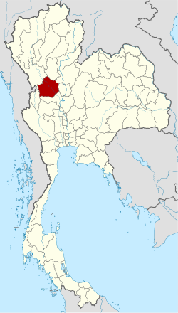
Kamphaeng Phet (Thai: กำแพงเพชร, pronounced[kām.pʰɛ̄ːŋpʰét]) is a province in upper central Thailand. It borders the provinces of Sukhothai to the north; Phitsanulok to the northeast; Phichit to the east; Nakhon Sawan to the south; and Tak to the west and northwest, covering over 8,607.49 square kilometres (3,323.37 sq mi) and is the fourth-largest provinces in central Thailand. Kamphaeng Phet has the Ping River flow through is main river of the province, making river flats make up much of the east of the province, while the west is mountainous which is part of Dawna Range and it covered with plentifully forest. Kamphaeng Phet known its natural environment and has a long history. National and historical parks in the province include Kamphaeng Phet Historical Park, Khlong Lan National Park, and Mae Wong National Park.
^"ข้อมูลสถิติดัชนีความก้าวหน้าของคน ปี 2565 (PDF)" [Human Achievement Index Databook year 2022 (PDF)]. Office of the National Economic and Social Development Council (NESDC) (in Thai). Retrieved 12 March 2024, page 18{{cite web}}: CS1 maint: postscript (link)
^"Gross Regional and Provincial Product, 2019 Edition". <>. Office of the National Economic and Social Development Council (NESDC). July 2019. ISSN 1686-0799. Retrieved 22 January 2020.
and 26 Related for: Kamphaeng Phet province information
KamphaengPhet (Thai: กำแพงเพชร, pronounced [kām.pʰɛ̄ːŋ pʰét]) is a province in upper central Thailand. It borders the provinces of Sukhothai to the north;...
KamphaengPhet is a town (thesaban mueang) in central Thailand, former capital of the KamphaengPhetProvince. It covers the complete tambon Nai Mueang...
Mueang KamphaengPhet (Thai: เมืองกำแพงเพชร, pronounced [mɯ̄a̯ŋ kām.pʰɛ̄ːŋ pʰét]) is the capital district (amphoe mueang) of KamphaengPhetprovince, central...
KamphaengPhet Historical Park is an archeological site in KamphaengPhet, Thailand. Along with Sukhothai Historical Park and Si Satchanalai historical...
UNESCO World Heritage Site which consists of Sukhothai historical park, KamphaengPhet historical park and Si Satchanalai historical park. These historical...
KamphaengPhet station (Thai: สถานีกำแพงเพชร, pronounced [sā.tʰǎː.nīː kām.pʰɛ̄ːŋ pʰét]) is a Bangkok MRT station on the Blue Line in Bangkok, Thailand...
Uttaradit, Phitsanulok, KamphaengPhet, Tak, and Lampang. Sukhothai can be translated as 'dawn of happiness'. The modern-day province of Sukhothai was named...
stadium in KamphaengPhetProvince, Thailand. It is currently used mostly for football matches and is the home stadium of KamphaengPhet F.C. The stadium...
district of KamphaengPhetprovince; Mae Wong district and Mae Poen district of Nakhon Sawan province; Ban Rai district of Uthai Thani province; and Thong...
KamphaengPhet Road (Thai: ถนนกำแพงเพชร, RTGS: Thanon KamphaengPhet, pronounced [tʰā.nǒn kām.pʰɛ̄ːŋ pʰét]) is a road in Thailand capital Bangkok, there...
Mountain Range. This park lies in Khlong Lan and Mueang KamphaengPhet districts of KamphaengPhetProvince, the Lower north of Thailand and occupies 187,500...
Uttaradit on the north, Loei and Phetchabun to the east, and Phichit and KamphaengPhet to the south. In the northeast it borders Laos. Its name means 'Vishnu's...
nāː]) is a tambon (subdistrict) of Sai Thong Watthana District, in KamphaengPhetProvince, Thailand. In 2019 it had a total population of 6,632 people. The...
Kamphaengphet Pittayakom School, a public secondary school in KamphaengPhetProvince, Thailand Katy Perry, American singer Kawan Prather, American record...
central part of KamphaengPhetprovince, central Thailand. Neighbouring districts are (from the north clockwise): Mueang KamphaengPhet, Sai Thong Watthana...
ná(ʔ).kʰɔ̄ːn]) is a district (amphoe) in the northwestern part of KamphaengPhetprovince, central Thailand. In Sukhothai Kingdom era, Mueang Kosamphi was...
for Chiang Mai province, next in the ranking and double than for Lampang province, which is third in the ranking. KamphaengPhetprovince had an economic...
Dao district, Chiang Mai province. After passing Chiang Mai, it flows through the provinces of Lamphun, Tak and KamphaengPhet. At the confluence with...
pronounced [pʰrāːn krā.tàːj]) is the northernmost district (amphoe) of KamphaengPhetprovince, central Thailand. The name of the district translates to 'rabbit...
part of KamphaengPhetprovince, central Thailand. Neighboring districts are (from the south clockwise) Sai Thong Watthana, Mueang KamphaengPhet, Phran...
into Pathum Thani Province, and on through Ayutthaya, Saraburi, Lopburi, Nakhon Sawan, Chainat, again through Nakhon Sawan, KamphaengPhet, Tak, Lampang,...
westernmost district (amphoe) of KamphaengPhetprovince, central Thailand. The area was originally part of Mueang KamphaengPhet district, then named Tambon...
[pāːŋ sì.lāː tʰɔ̄ːŋ]) is the southwesternmost district (amphoe) of KamphaengPhetprovince, central Thailand. The government split tambons Pang Ta Wai, Hin...
 Global Information