This article is about the district. For its eponymous headquarters, see Kamareddy.
District in Telangana, India
Kamareddy district
District
Temple at Domakonda fort
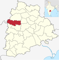
Location in Telangana
Kamareddy district
Country
India
State
Telangana
Headquarters
Kamareddy
Mandalas
23
Government
• District Collector
Shri Jithesh V Patil IAS
• Parliament constituencies
1
Area
• Total
3,652 km2 (1,410 sq mi)
Population
(2015)
• Total
1,004,259
• Density
277.2/km2 (718/sq mi)
Demographics
• Literacy
56.51
• Sex ratio
1033
Time zone
UTC+05:30 (IST)
Vehicle registration
TG–17[1]
Website
kamareddy.telangana.gov.in
Kamareddy district is a district located in the western region of the Indian state of Telangana.[2][3] The district shares boundaries with Medak, Nizamabad, Sangareddy, Siddipet and Rajanna Sircilla districts and with the state boundary of Maharashtra and Karnataka.
^"Telangana New Districts Names 2016 Pdf TS 31 Districts List". Timesalert.com. 11 October 2016. Retrieved 11 October 2016.
^"Kamareddy district" (PDF). Chief Commissioner of Land Administration. Archived from the original (PDF) on 9 September 2016. Retrieved 22 August 2016.
^"New districts map". newdistrictsformation.telangana.gov.in. Retrieved 22 August 2016.[permanent dead link]
and 28 Related for: Kamareddy district information
Kamareddydistrict is a district located in the western region of the Indian state of Telangana. The district shares boundaries with Medak, Nizamabad...
Kamareddy is a city and headquarters of the Kamareddydistrict in Telangana state in India. It is located about 117 kilometres (73 mi) north of the state...
Kamareddy Assembly constituency is a constituency of Telangana Legislative Assembly, India. It is one of four constituencies in Kamareddydistrict. It...
district headquarters. The district share boundaries with Jagtial, Sircilla, Nirmal, Kamareddydistricts and with Nanded district of the state boundary of...
comprises three constituencies from Medak district and four assembly constituencies from Kamareddydistrict. Zahirabad Lok Sabha constituency comprises...
Collector and District Magistrate of Bhadradri Kothagudem District who was earlier Collector and District Magistrate of KamareddyDistrict and Dr Priyanka...
the Godavari River, between Achampet and BanjePally villages of the Kamareddydistrict in Telangana, India. It is located at about 144 km (89 mi) north-west...
Wargal) The district shares boundaries with Jangaon, Sircilla, Karimnagar, Kamareddy, Hanamkonda, Yadadri, Medhchal and Medak districts. This district is bounded...
Jagtial, Kamareddy, and Nizamabad districts. The district is spread over an area of 2,030.89 square kilometres (784.13 sq mi). This district is bounded...
Baswapoor village Bhiknoor mandal, Kamareddydistrict. He belongs to Puragiri Kshatriya/Perika community. He won Kamareddy assembly constituency on Telugu...
Telangana with 9 mandals, out of which 6 are in Nizamabad district and other 3 in Kamareddydistrict. It is part of Zahirabad Lok Sabha constituency. Pocharam...
Banswada is a Town and Revenue division in Kamareddydistrict of the Indian state of Telangana. Banswada is located at 18°23′00″N 77°53′00″E / 18.3833°N...
The district shares boundaries with Sangareddy, Kamareddy, Siddipet and Medchal-Malkajgiri districts. Traces of Neolithic and Megalithic culture was found...
Bichkunda or Bichkonda is a Mandal in Kamareddydistrict of state of Telangana, India. Bichkunda is located at 18°24′00″N 77°43′00″E / 18.4000°N 77.7167°E...
Jukkal is a city in the Kamareddy revenue division of Kamareddydistrict in the Indian state of Telangana. Telugu is the official language here. Apart...
Pitlam is a Town and Mandal in the Kamareddy revenue division of the kamareddydistrict in the Indian state of Telangana. Pitlam is a developing town located...
the Godavari River, between Achampet and BanjePally villages of the Kamareddydistrict in Telangana, India. It is located at about 144 km (89 mi) northwest...
Telangana Legislative Assembly, India. It is one of 4 constituencies in Kamareddydistrict. It is part of Zahirabad Lok Sabha constituency. Currently the constituency...
village and a mandal in Kamareddydistrict in the state of Telangana. It is located 20 km towards from district headquarters Kamareddy. 18°21′35″N 78°24′53″E...
Lingampet is a panchayat village in Kamareddydistrict in the state of Telangana in India. Lingampet is located east of the south-flowing Allair River...
Bhiknur is a village and a Mandal in Kamareddydistrict in the state of Telangana in India. "Mandals in Nizamabad district". Archived from the original on...
Revenue division in Kamareddydistrict of the Indian state of Telangana. It is located in Yellareddy mandal of KamareddyDistrict. It was previously in...
Domakonda is a village in the Kamareddydistrict of the Indian state of Telangana. It is located in Domakonda mandal. "District Level Mandal wise List of...
the west. On the eastern side lies Adilabad, Nirmal, Nizamabad and Kamareddydistricts of Telangana state, and on the south lies Bidar of Karnataka state...
Tadwai is a village and a mandal in Kamareddydistrict in the state of Telangana in India, located between Kamareddy and Nijamsagar. Tadwai is home to the...
registration. These are broken down to states or union territories and their districts. The Andhra Pradesh state government has decided to issue uniform registration...
finally, the Asaf Jahi rulers of the Hyderabad State. It is in the Kamareddydistrict, near the trijunction of Telangana, Karnataka and Maharashtra states...
district shares boundaries with Medak, Medchal, Vikarabad, Kamareddy and Rangareddy districts and with the state boundary of Karnataka. The district is...
 Global Information