You can help expand this article with text translated from the corresponding article in Spanish. (January 2023) Click [show] for important translation instructions.
Machine translation, like DeepL or Google Translate, is a useful starting point for translations, but translators must revise errors as necessary and confirm that the translation is accurate, rather than simply copy-pasting machine-translated text into the English Wikipedia.
Do not translate text that appears unreliable or low-quality. If possible, verify the text with references provided in the foreign-language article.
You must provide copyright attribution in the edit summary accompanying your translation by providing an interlanguage link to the source of your translation. A model attribution edit summary is Content in this edit is translated from the existing Spanish Wikipedia article at [[:es:Departamento de Jutiapa]]; see its history for attribution.
You may also add the template {{Translated|es|Departamento de Jutiapa}} to the talk page.
For more guidance, see Wikipedia:Translation.
Department of Guatemala
Jutiapa Department
Departmento de Jutiapa
Department of Guatemala
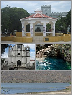
From the top: Park and kiosk, Church, Anda Mira Cave and Atescatempa Lagoon.
Flag
Coat of arms
Jutiapa and its neighbors[a]
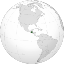
Guatemala on the Western Hemisphere
Country
Guatemala
Capital
Jutiapa
Municipalities
17
Government
• Type
Departmental
Area
• Department of Guatemala
3,219 km2 (1,243 sq mi)
Population
(2018)[1]
• Department of Guatemala
488,395
• Density
150/km2 (390/sq mi)
• Urban
249,754
• Religions
Roman Catholicism Evangelicalism
Time zone
UTC-6
Jutiapa Department is a department of Guatemala that borders along El Salvador and the Pacific Ocean. The capital is the city of Jutiapa. As of 2018, it has a population of 488,395.[1] The department is divided into seventeen municipalities. Jutiapa is the country's southeasternmost department and officially the only department with no Mayan descendants native to the region. The main crops are sorghum, tobacco, onion and corn. The climate is dry. An important attraction is the cattle fair. It is at 405 m above sea level.
The population is ethnically "Ladino" (of European descent & non Mayan-indigenous), though in the northern regions of Jutiapa there are few descendants that once belonged to the Xinca population. The Xinca people were of non-Mayan descent.
The coat of arms contains the cornucopia symbolizing Jutiapa as the barn of the East, supplying Guatemala with most of the grain consumed by the people. The horse and the cow represent the cattle; the books stand for educational and cultural advances. In the background sits La Cruz hill, the firm guardian of the departmental chief town, with the tower or antenna of a Jutiapa radio station. Behind the hill float the clouds, the sky and the sun of Jutiapa, "The Sun City". This coat of arms is placed on the flag between two laurel branches symbolizing the daily triumphs of the sons of Jutiapa. The flag is mainly white, showing in its center the coat of arms adapted and adroned, between two laurel branches.
Cite error: There are <ref group=lower-alpha> tags or {{efn}} templates on this page, but the references will not show without a {{reflist|group=lower-alpha}} template or {{notelist}} template (see the help page).
^ abCitypopulation.de Population of departments in Guatemala
and 16 Related for: Jutiapa Department information
JutiapaDepartment is a department of Guatemala that borders along El Salvador and the Pacific Ocean. The capital is the city of Jutiapa. As of 2018, it...
Jutiapa is a city and a municipality in the Jutiapadepartment of Guatemala. Located 124 km from the city of Guatemala City, at an altitude of 892 m (2...
Deportivo Achuapa, is a Guatemalan football club based in El Progreso, JutiapaDepartment. They compete in the Liga Nacional, the top tier of Guatemalan football...
the main Pipil population in what is now Santa Rosa department; there were also Xinca in Jutiapa. In Guazacapán, now a municipality in Santa Rosa, Pedro...
now extinct. Yupiltepeque was spoken in JutiapaDepartment, while the rest were spoken in Santa Rosa Department. Campbell also suggests that the Alagüilac...
Assumed office 14 January 2024 Constituency Jutiapa Personal details Born (1979-05-12) 12 May 1979 (age 45) Jutiapa, Jutiapa Political party Blue Party...
Progreso Department, smallest department in population, whose capital is Guastatoya El Progreso, Jutiapa, municipality in the Jutiapadepartment Nuevo Progreso...
Fort 13°42′N Guatemala Border with El Salvador near Garita Chapina, JutiapaDepartment 13°44′N Laos Border with Cambodia near Veun Kham, Khong District...
567 Geography Country El Salvador/Guatemala State Santa Ana Department/JutiapaDepartment Geology Volcanic arc Central America Volcanic Arc Last eruption...
in Sacatepéquez Department Santa Catarina Ixtahuacan, a town in Sololá Department Santa Catarina Mita, a town in JutiapaDepartment Santa Catarina Palopó...
Herbruger Personal details Born (1946-11-26) 26 November 1946 (age 77) Horcones, JutiapaDepartment, Guatemala Political party Solidarity Action Movement...
children and drunken husbands. On the Guatemalan side of Lake Güija, in JutiapaDepartment, the Siguanaba is able to take on many forms but the most common is...
into 22 departments (Spanish: departamentos) which in turn are divided into 340 municipalities. The departments are governed by a departmental governor...
Guatemala Escuintla Department, JutiapaDepartment, Retalhuleu Department, San Marcos Department, Santa Rosa Department, Suchitepéquez Department 14°28′47″N 92°07′23″W...
border with Mexico, Petén Department Southernmost point – border with El Salvador, near Garita Chapina, JutiapaDepartment Westernmost point – border...
[xalpaˈtaɣwa]) is a town and municipality in the Jutiapadepartment of Guatemala. Citypopulation.de Population of departments and municipality in Guatemala ALL ABOUT...
 Global Information