 Global Information
John Day River information
| John Day River | |
|---|---|
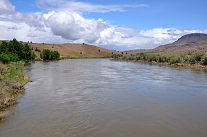 John Day River at Clarno | |
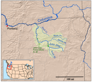 Map of the John Day watershed | |
| Etymology | John Day, a hunter and fur trapper[1] |
| Native name | Mah-Hah (Cayuse) |
| Location | |
| Country | United States |
| State | Oregon |
| Physical characteristics | |
| Source | Strawberry Mountains |
| • location | Malheur National Forest, Grant County |
| • coordinates | 44°14′44″N 118°33′08″W / 44.245439°N 118.5521617°W[2] |
| • elevation | 6,681 ft (2,036 m)[3] |
| Mouth | Columbia River |
• coordinates | 45°43′57″N 120°38′57″W / 45.7326252°N 120.6492244°W[2] |
• elevation | 268 ft (82 m)[3] |
| Length | 284 mi (457 km)[4][5] |
| Basin size | 8,000 sq mi (21,000 km2)[5] |
| Discharge | |
| • location | USGS gage 14048000, McDonald Ferry, river mile 20.9, 45°35′16″N 120°24′30″W / 45.587778°N 120.408333°W[6] |
| • average | 2,075 cu ft/s (58.8 m3/s)[6] |
| • minimum | 0 cu ft/s (0 m3/s) |
| • maximum | 43,300 cu ft/s (1,230 m3/s) |
| Basin features | |
| Tributaries | |
| • left | South Fork John Day River |
| • right | North Fork John Day River |
National Wild and Scenic River | |
| Type | Recreational |
| Designated | October 28, 1988 |

The John Day River is a tributary of the Columbia River, approximately 284 miles (457 km) long, in northeastern Oregon in the United States. It is known as the Mah-Hah River by the Cayuse people. Undammed along its entire length, the river is the fourth longest free-flowing river in the contiguous United States. There is extensive use of its waters for irrigation. Its course furnishes habitat for diverse species, including wild steelhead and Chinook salmon runs.[4][7] However, the steelhead populations are under federal Endangered Species Act (ESA) protections, and the Chinook salmon have been proposed for such protection.
The river was named for John Day, a member of the Pacific Fur Company's overland expedition to the mouth of the Columbia River that left Missouri in 1810. Day struggled through eastern Oregon during the winter of 1811–12. While descending the Columbia River in April 1812, he and Ramsay Crooks were robbed and stripped naked by Native Americans at the mouth of the river that now bears his name, forcing them to hike 80 miles (130 km) back to friendly Umatilla Indians under extreme conditions.[1]
The absence of dams on the river causes its flow to greatly fluctuate throughout the year depending on snowpack and rainfall within the watershed.[8] The highest flow recorded at a gauge on the lower John Day was 43,300 cubic feet per second (1,230 m3/s) on January 2, 1997. The lowest flow was no flow at all, which occurred on September 2, 1966; from August 15 to September 16, 1973; and on nine days in August 1977. The average flow at the gauge is 2,075 cubic feet per second (58.8 m3/s).[6]
- ^ a b Topinka, Lyn. "John Day River, Oregon". Columbia River Images. Retrieved July 6, 2013.
- ^ a b "John Day River". Geographic Names Information System. United States Geological Survey, United States Department of the Interior. November 28, 1980. Retrieved July 6, 2013.
- ^ a b Source and mouth elevations derived from Google Earth using GNIS coordinates.
- ^ a b "John Day River". Oregon Environmental Council. Archived from the original on May 4, 2013. Retrieved July 6, 2013.
- ^ a b "John Day Subbasin Plan", p. 18
- ^ a b c "Water-Data Report 2012: 14048000 John Day River at McDonald Ferry, OR" (PDF). U.S. Geological Survey. Retrieved July 6, 2013.
- ^ "John Day Subbasin Plan", p. 31
- ^ "John Day River: Boating General Information". Bureau of Land Management. Archived from the original on July 20, 2013. Retrieved July 6, 2013.