 Global Information
Jesusland map information
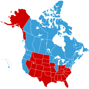

The Jesusland map is an Internet meme created shortly after the 2004 U.S. presidential election that satirizes the red/blue states scheme by dividing the United States and Canada into "The United States of Canada" and "Jesusland".[1] The map implies the existence of a fundamental political divide between contiguous northern and southern regions of North America, the former including both the socially liberal Canada and the West Coast, Northeastern, and Upper Midwestern states, and suggests that these states are closer in spirit to Canada than to the more conservative regions of their own country. The Freakonomics blog opined that the map reflected the "despair, division, and bitterness" of the election campaign and results.[2] Slate also covered the image and posited that it might be the reason the Canadian immigration website received six times its usual page views the day after the 2004 election.[3]
- ^ Bai, Matt (November 19, 2006). "The Last 20th-Century Election?". The New York Times Magazine. Retrieved 13 December 2009.
Since Bush's disputed victory in 2000, many liberals have been increasingly brazen about their disdain for the rural and religious voters; one popular e-mail message, which landed in thousands of Democratic in-boxes in the days after the 2004 election, separated North America into 'The United States of Canada' and 'Jesusland.'
- ^ Mengisen, Annika (November 9, 2009). "Maps: Fighting Disease and Skewing Borders". Freakonomics blog, from The New York Times. Retrieved 13 December 2009.
- ^ Lithwick, Dahlia; Lithwick, Alex (November 5, 2004). "Moving to Canada, Eh?". Slate. Retrieved 4 September 2015.