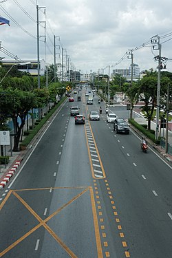
Itsaraphap Road in the phase of Chinorot Wittayalai School (left) and Royal Thai Navy Headquarters (right).
Itsaraphap Road (Thai: ถนนอิสรภาพ, pronounced[tʰā.nǒnʔìt̚.sā.rā.pʰâːp̚]) is a main road in Bangkok's Thonburi side (west bank of Chao Phraya River). It is also the location of the Itsaraphap MRT station, the Blue Line extension station and the only underground station on the Thonburi side.
It has a starting point at Lat Ya Junction in the area of Khlong San Subdistrict, Khlong San District, where it meets Lat Ya and Tha Din Daeng Roads then westward cuts across Ban Khaek Intersection, where it meets Prajadhipok Road in the areas of Hiran Ruchi and Wat Kanlaya Subdistricts, Thon Buri District, then spans Khlong Bangkok Yai canal on Charoenphat Bridge and into the area of Bangkok Yai District (this phase it also serves as a delineates line between Wat Arun and Wat Tha Phra Subdistricts) and cuts across Pho Sam Ton Junction, where it meets Wang Doem Road, as far as spans Khlong Mon and into the area of Ban Chang Lo Subdistrict, Bangkok Noi District, where it bends slightly north and cuts across Phran Nok Intersection, where it meets Phran Nok and Wang Lang Roads (this phase it also serves as a delineates line between Ban Chang Lo and Siri Rat Subdistricts), as far as ending at Ban Noen Junction in the areas of Ban Chang Lo and Siriraj Subdistricts near Thonburi Railway Station and Siriraj Hospital (section Siriraj Piyamaharajkarun Hospital), total distance of 4.18 km (2 mi 1,051 yd).
It was built in the year 1931 during the King Prajadhipok (Rama VII)'s reign after the construction of a Memorial Bridge linked between Phra Nakhon and Thonburi sides was completed.[1] It was regarded as one of the 11 roads in the Thonburi area traffic expansion project, along with other roads such as Tha Din Daeng, Phran Nok, Somdet Chao Phraya etc. The road was once called "Chao Krung Thon Road" (ถนนเจ้ากรุงธน, lit: "the road of the King of Thon Buri") not long after its construction, however, the King Taksin Monument was built right in the middle of Wongwian Yai, so the name of the road was likewise changed to honour the monarch who declared Siam’s independence from the Burmese. (Itsaraphap means "independence" or "freedom" in Thai).[2]
Although it is short, Itsaraphap Road runs through important places such as Dhonburi Rajabhat University, Bansomdej Chaopraya Rajabhat University, Wat Ratchasittharam, Royal Thai Navy Headquarters, Taweethapisek School, Thonburi Hospital, Wat Chinorot and Chinorot Wittayalai School etc. It also runs through three other mosques of Shia sect, namely Kudi Charoenphat, Dilfulla Mosque, and Phadungtham Islam Mosque.[3][4]
^"สถานีรถไฟธนบุรี มีประวัติศาสตร์สงครามโลก" [Thonburi Railway Station have a history of World War]. Sinlapa Watthanatham (in Thai). 2016-01-19. Retrieved 2019-10-03.
^Panomai, Suriyan (2016-09-06). "Things to do in Itsaraphap". Timeout.com. Retrieved 2019-10-03.
^"มุสลิมในธนบุรี" [Muslims in Thonburi]. Prachatai (in Thai). 2005-08-06. Retrieved 2019-10-03.
^"ขรรค์ชัย-สุจิตต์ ทอดน่องสองแผ่นดิน 'พระนคร-ธนบุรี' เปิดประวัติศาสตร์ 4 สถานีรถไฟฟ้าสายสีน้ำเงิน" [Khanchai-Sujit strolls two areas 'Phra Nakhon-Thonburi' opening history of 4 Blue Line MRT stations]. Matichon (in Thai). 2019-08-03. Retrieved 2019-10-03.
ItsaraphapRoad (Thai: ถนนอิสรภาพ, pronounced [tʰā.nǒn ʔìt̚.sā.rā.pʰâːp̚]) is a main road in Bangkok's Thonburi side (west bank of Chao Phraya River)...
ft) in depth, traversing horizontally under the ItsaraphapRoad from Soi Itsaraphap 23 to Soi Itsaraphap 34. The design of this station is based on the...
first phase in April 2021. Arun Amarin Road is regarded as the road at the mostly distance parallel to ItsaraphapRoad. Arun Amarin Intersection, where it...
hospital under Thonburi Healthcare Group, located on Soi Itsaraphap 44 (Soi Saeng Sueksa), ItsaraphapRoad, Ban Chang Lo Subdistrict, Bangkok Noi District, Bangkok...
is surrounded by canals on all parts except on the east part with ItsaraphapRoad serves as boundary line between Wat Tha Phra and Wat Arun Subdistricts...
markets on ItsaraphapRoad near Phran Nok and Ban Noen intersections including Bangkok Noi railway station Sri Yan Market: On Nakhon Chai Si Road in Dusit...
Lo in the past, was not very large. North, next to Phran Nok Road, south to Soi Itsaraphap 44 (Soi Saeng Sueksa), east to Khlong Ban Khamin, west to Phran...
ItsaraphapRoad at Ban Khaek Intersection. An area is bounded by other sub-districts (from north clockwise): Wat Kanlaya in its district (Itsaraphap Road...
railway station (now Thon Buri railway station) and the northern end of Itsaraphaproad The distance between Khlong Wat Tai Talat and Khlong Ban Mo, there...
(Rama II). The area is served by the Itsaraphap Station of the MRT Subway, whose Blue Line runs under the ItsaraphapRoad near Wat Hong Rattanaram and historic...
District Bangkok Yai Province Bangkok Region Thonburi Location Location ItsaraphapRoad, Wat Arun Subdistrict, Bangkok Yai District, Bangkok Location within...
same year. Phran Nok Intersection, where the road cuts across ItsaraphapRoad, and where Wang Lang Road ends. It is a source of many southern Thai restaurants...
in Thon Buri side, Bangkok. It's the three-way of Arun Ammarin Road and Soi Itsaraphap 44 (Saeng Sueksa). The name "Ban Khamin" after this area in the...
Ban Khaek, a four-way intersection, where Prajadhipok cuts across ItsaraphapRoads on the boundary of Hiran Ruchi and Wat Kanlaya of Thon Buri with Somdet...
regarded as one of four most beautiful MRT stations; the other three being Itsaraphap station, Sanam Chai station and Sam Yot station. The station is situated...
stations that are recognized for their most beautiful design (consisted of Itsaraphap station, Sanam Chai station, Sam Yot station, and Wat Mangkon station)...
three are Itsaraphap station, Sanam Chai station, and Wat Mangkon station. It is located underground from Sam Yot Intersection of Charoen Krung Road and Maha...
Bangkok MRT station on the Blue Line located under Lat Phrao Road and Phahon Yothin Road, which the station is named after, near Lat Phrao Square. The...
Blue Line, located below Asok Intersection between Sukhumvit Road and Asok Montri Road in Bangkok, Thailand. The station provides an interchange with...
Song Bang Khae Phasi Charoen Phetkasem 48 Bang Wa Bang Phai Tha Phra Itsaraphap Sanam Chai Sam Yot Wat Mangkon Hua Lamphong Sam Yan Si Lom Lumphini Khlong...
station on the Blue Line in Bangkok, Thailand. It is beneath Kamphaeng Phet Road (Thanon), providing a direct access to the Chatuchak Weekend Market and OrTorKor...
station on the Blue Line, in Thailand. It is located on Rama IV Road, near Witthayu Road and Lumphini Park. Although the station's name refers to Lumphini...
G-Land developments around the road junction of the same name, where Din Daeng, Asok-Din Daeng, Ratchadaphisek and Rama IX roads intersect. The master plan...
 Global Information