 Global Information
Hydrography of the Biella region information
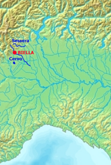
The hydrography of the Biella region, that is, the distribution of surface water in the province of Biella, Italy, falls almost entirely in the two basins of the Cervo and Sessera rivers, both tributaries of the Sesia. Some areas of the southwestern Biella region, on the other hand, are tributaries of the Dora Baltea; the largest natural body of water in the province, Lake Viverone, is also located in this area.[1] In addition to the natural bodies of water, there are several irrigation canals in the plains built mainly to support rice cultivation and some reservoirs built in the foothills.[2] In addition to irrigation, surface water is also used in the Biella area to serve the region's numerous industries and for potable water use, because the area is densely inhabited and groundwater capture is insufficient. Hydroelectric use, on the other hand, is very limited and is substantially confined to the Sessera Valley.[3] The streams of the Biella region can be subject to ruinous floods as well, which have caused numerous damage to property and people over time.[4]
 |
- ^ Assessorato alla Pianificazione Territoriale della Provincia di Biella (2004). "Fisiografia e pericolosità ambientale". Variante n.1 al Piano Territoriale Provinciale - Matrice ambientale. Archived from the original (pdf) on May 5, 2014. Retrieved September 1, 2009.
- ^ AA.VV. (2007). "5 - Idrologia e idraulica". Bilancio delle disponibilità idriche naturali e valutazione dell’incidenza dei prelievi nel bacino del Fiume Sesia (pdf). Retrieved September 1, 2009.
- ^ AA.VV (2006). Variante n. 1 al Piano Territoriale Provinciale della Provincia di Biella - Valutazione Ambientale Strategica (pdf). Provincia di Biella. Retrieved October 8, 2009.
- ^ Tropeano (CNR/IRPI e GNDCI), Domenico. "Eventi alluvionali e frane in Italia Settentrionale". nimbus.it. Archived from the original on July 15, 2006. Retrieved October 1, 2009.