Major drainage basin in Canada and the United States
Hudson Bay drainage basin
The Hudson Bay drainage connects primarily to the Labrador Sea just south of Davis Strait, as depicted on most atlases such as those of the National Geographic Society, just north of the 60th parallel north and northeast of the Labrador Peninsula
Area
3,861,400 km2 (1,490,900 sq mi)
Geology
Type
Drainage basin
Geography
Location
North America
Country
Canada
United States
Coordinates
60°N86°W / 60°N 86°W / 60; -86
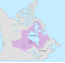
The Hudson Bay drainage basin is the drainage basin in northern North America where surface water empties into the Hudson Bay[1] and adjoining waters. Spanning an area of about 3,861,400 square kilometres (1,490,900 sq mi) and with a mean discharge of about 30,900 m3/s (1,090,000 cu ft/s),[2] the basin is almost entirely within Canada. It encompasses parts of the Canadian Prairies, Central Canada, and Northern Canada. A small area of the basin is in the northern part of the Midwestern United States.
Rupert's Land, granted as a commercial monopoly to the Hudson's Bay Company in 1670
The Hudson Bay drainage basin coincides almost completely with the former territory of Rupert's Land, claimed by the Hudson's Bay Company in the 17th century. It was an ideal area for the early North American fur trade.[3]
^"Hudson Bay". Canadian Geographical Names Database. Government of Canada. Retrieved 10 April 2024.
^"Canada Drainage Basins". The National Atlas of Canada, 5th edition. Natural Resources Canada. 1985. Retrieved 24 November 2010.
^McIntosh, Andrew; Smith, Shirlee Anne (7 February 2006). "Rupert's Land". The Canadian Encyclopedia. Retrieved 11 April 2024.
and 19 Related for: Hudson Bay drainage basin information
The HudsonBaydrainagebasin is the drainagebasin in northern North America where surface water empties into the HudsonBay and adjoining waters. Spanning...
The list of drainagebasins by area identifies basins (also known as "catchments" or, in North American usage, "watersheds"), sorted by area, which drain...
Crown granted a charter to facilitate fur trading within the HudsonBaydrainagebasin. France contested this grant by sending several military expeditions...
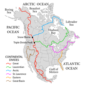
Ocean, the Gulf of Mexico, and HudsonBay. The watersheds divide at Triple Divide Peak in Glacier National Park. If HudsonBay is considered part of the Arctic...
(9.3 mi) southeast of Flin Flon, Manitoba. The lake is in the HudsonBaydrainagebasin and is the source of the Goose River. Lake Athapapuskow consists...
Kenora District in Northwestern Ontario, Canada. It is part of the HudsonBaydrainagebasin. The river begins at an unnamed lake and flows northeast, then...
District in northwestern Ontario, Canada. The lake is in the HudsonBaydrainagebasin and is the source of the Fishbasket River. The lake is 14 kilometres...
The Columbia River drainagebasin is the drainagebasin of the Columbia River in the Pacific Northwest region of North America. It covers 668,000 km2 or...
northwest part of the state northward toward Canada's HudsonBay. This list is arranged by drainagebasin with respective tributaries indented under each larger...
River District in northwestern Ontario, Canada. It is part of the HudsonBaydrainagebasin. The primary inflow is the Black River at the east. The primary...
An endorheic basin (/ˌɛndoʊˈriː.ɪk/ EN-doh-REE-ik; also endoreic basin and endorreic basin) is a drainagebasin that normally retains water and allows...
authorization of a royal charter, the Hudson'sBay Company established the territory of Rupert's Land in the HudsonBaydrainagebasin. The English also established...
Gulf of Mexico basin, the Great Lakes-St. Lawrence basin, the Pacific basin, the Arctic basin, the HudsonBaybasin, and the Great Basin. Together, the...
Kenora District in Northwestern Ontario, Canada. It is in the HudsonBaydrainagebasin, and is within Woodland Caribou Provincial Park. The primary inflows...
 Global Information