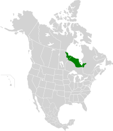
Wetland located between the Canadian Shield and Hudson Bay
The Hudson Bay Lowlands is a vast wetland located between the Canadian Shield and southern shores of Hudson Bay and James Bay. Most of the area lies within the province of Ontario, with smaller portions reaching into Manitoba and Quebec. Many wide and slow-moving rivers flow through this area toward the saltwater of Hudson Bay: these include the Churchill, Nelson and Hayes in Manitoba, Severn, Fawn, Winisk, Asheweig, Ekwan, Attawapiskat, and Albany in Ontario, and the Harricana, Rupert and Eastmain in Quebec.[1] This is the largest wetland in Canada, and one of the largest in the world.[2] The region can be subdivided into three bands running roughly northwest to southeast: the Coastal Hudson Bay Lowland (a narrow band along the northern coast),[3] Hudson Bay Lowland (a broader band extending to slightly south of the Ekwan River),[4] and James Bay Lowland (all the rest of the southern/eastern lands, making up close to 50% of the total Lowlands area).[5]
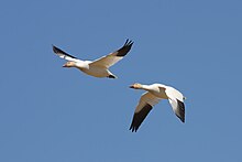
The entire area was covered by ice during the last glaciation, and the peatlands have accumulated over the last ten thousand years. Plants from more temperate regions mix with arctic species.[6] A majority of the wetland is peat bog, although salt marshes occur along the coast, and marshes and wet meadows occur along the major rivers. The wetlands provide important habitat for migratory birds including shorebirds (e.g., yellow rail) and waterfowl (e.g., snow geese). Large mammals include polar bears and wolverines.[2]
The Hudson Bay Lowlands approximately coincide with the Southern Hudson Bay taiga ecoregion of North America.Snow geese migrate north each year to breed in the coastal marshes of the Hudson Bay Lowlands.
^Canadian Encyclopedia - Hudson Bay
^ abAbraham, K.F. and C.J. Keddy. The Hudson Bay Lowland. Pages 118–148 in L.H. Fraser and P.A. Keddy (eds.). 2005. The World's Largest Wetlands: Ecology and Conservation. Cambridge University Press, Cambridge, UK. 488 p.
^Coastal Hudson Bay Lowland ecozone profile
^Hudson Bay Lowland ecozone profile
^James Bay Lowland ecozone profile
^Riley, John L. 2003. Flora of the Hudson Bay Lowland and its Postglacial Origins. NRC Research Press, Ottawa, Canada. 236 p.
and 28 Related for: Hudson Bay Lowlands information
The HudsonBayLowlands is a vast wetland located between the Canadian Shield and southern shores of HudsonBay and James Bay. Most of the area lies within...
plains, the Great Lakes-St. Lawrence Lowlands, the Appalachian region, the Western Cordillera, HudsonBayLowlands and the Arctic Archipelago. Canada is...
bay are a lowland known as the HudsonBayLowlands which covers 370,000 km2 (140,000 sq mi). The HudsonBayLowlands are a peatland. The HudsonBay Lowlands...
Lake, is made of rocks dating 1.8 to 2.4 billion years ago. The HudsonBaylowlands, located north of the Canadian Shield, are mainly made of sedimentary...
the Canadian Shield, the Hudson BayLowlands, the Interior Plains, the Cordillera, the Great Lakes–St. Lawrence Lowlands, and the Appalachian Uplands. There...
shore, however, is characterised by broad tundra lowlands that are an extension of the HudsonBayLowlands, and the vegetation is mostly muskeg bog. A large...
shore where James Bay joins HudsonBay. The terrain is part of the HudsonBayLowlands and features unspoiled low-lying tundra in the Hudson Plains ecozone...
northwestern Ontario, Canada. It is part of the James Bay drainage basin and is in the HudsonBayLowlands area. There are two unnamed inflows, at the south...
plains, the Great Lakes-St. Lawrence Lowlands, the Appalachian region, the Western Cordillera, HudsonBayLowlands, and the Arctic Archipelago. Boreal...
Lake, is made of rocks dating 1.8 to 2.4 billion years ago. The HudsonBaylowlands, located north of the Canadian Shield, are mainly made of sedimentary...
the Arctic Ocean via HudsonBay. Alternative geographic classifications also commonly refer to the region as the HudsonBayLowlands. The Palaeozoic and...
into an nonlinear and uncoordinated "belt" around the Hudson Basin. Within the HudsonBayLowlands, the formation consists of dolomite and limestone rich...
Missinaibi Formation is a Late Pleistocene geologic formation in the HudsonBayLowlands in Northern Ontario, Canada. The formation lies within Missinaibi...
Northwestern Ontario and Northeastern Ontario. The virtually unpopulated HudsonBayLowlands in the extreme north and northeast are mainly swampy and sparsely...
and H. G. Lumsden. (1977). "Nesting ecology of Canada Geese in the HudsonBayLowlands of Ontario: Evolution and population regulation". Fish Wildl. Res...
Expedition into the Unknown (about a previous expedition into the HudsonBaylowlands) just crossed 4,000 kilometres of remote, Arctic mainland Canada...
Township in the Unorganized North Part of Cochrane District, in the HudsonBayLowlands. Here the Mattagami's confluence with the Missinaibi River forms...
to the HudsonBayLowlands. In fur trade days the Missinaibi was the main route between James Bay and Lake Superior. The route was: James Bay, Moose Factory...
Carolina, United States Honey Island Swamp, Louisiana, United States HudsonBayLowlands, Ontario, Canada Limberlost, Indiana, United States Louisiana swamplands...
distinct from the Arctic Region (which consists largely of lowlands). The Arctic and HudsonBayLowlands comprise a substantial part of the geographic region...
land, such as the bed of recently drained Lake Agassiz and in the HudsonBaylowlands, in the retreat of grassland before an advancing forest border in...
of the world's largest peatlands include the West Siberian Lowland, the HudsonBayLowlands, and the Mackenzie River Valley. There is less peat in the...
Northwestern Ontario and Northeastern Ontario. The virtually unpopulated HudsonBayLowlands in the extreme north and northeast are mainly swampy and sparsely...
 Global Information