This article needs additional citations for verification. Please help improve this article by adding citations to reliable sources. Unsourced material may be challenged and removed. Find sources: "Hualapai" – news · newspapers · books · scholar · JSTOR(March 2007) (Learn how and when to remove this message)
Ethnic group
Hualapai Tribe
Hwalbáy(Walapai)
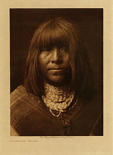
Ta'thamiche, Hualapai 1907 photo by Edward Curtis
Total population
2,300 enrolled members
Regions with significant populations
United States (Arizona)
Languages
Hualapai, English
Religion
Indigenous, Christianity
Related ethnic groups
Mohave, Yavapai, Havasupai
The Hualapai (pronounced[walapaɪ], wah-lah-py, Walapai: Hwalbáy[1]) is a federally recognized Native American tribe in Arizona with about 2300 enrolled members. Approximately 1353 enrolled members reside on the Hualapai Reservation, which spans over three counties in Northern Arizona (Coconino, Yavapai, and Mohave).[2]
The name, meaning "people of the tall pines", is derived from hwa:l, the Hualapai word for ponderosa pine[2] and pai "people". Their traditional territory is a 108-mile (174 km) stretch along the pine-clad southern side of the Grand Canyon and the Colorado River with the tribal capital at Peach Springs. Other communities on the reservation include Valentine and Grand Canyon West.
^Watahomigie, Lucille, Jorigine Bender, Akira Yamamoto, University of Los Angeles. Hualapai reference grammar. 1982.
The Hualapai (pronounced [walapaɪ], wah-lah-py, Walapai: Hwalbáy) is a federally recognized Native American tribe in Arizona with about 2300 enrolled members...
The Hualapai Mountains are a mountain range located in Mohave County, east of Kingman, Arizona. Rising up to 8,417 feet at its highest peak, the higher...
The Hualapai War, or Walapai War, was an armed conflict fought from 1865 to 1870 between the Hualapai native Americans and the United States in Arizona...
Hualapai Peak is a 8,417-foot (2,566 m) mountain summit in Mohave County, Arizona and is the highest point of the Hualapai Mountains. It is located about...
Hemileuca hualapai, the hualapai buckmoth, is a species of insect in the family Saturniidae. It is found in Central America and North America. The MONA...
Hualapai Flat (pronounced "wall-a-pie") is a valley in northwestern Nevada, United States, located northwest of the Black Rock Desert. The two valleys...
Arizona, about 50 miles (80 km) south. Commissioned and owned by the Hualapai Indian tribe, the skywalk was unveiled March 20, 2007, and opened to the...
Havasupai and the Hualapai are one people, although today, they are politically separate groups due to U.S. government policy. The Hualapai (Pa'a or Pai)...
Kiowa Joseph Gordon is a Native American actor of Hualapai heritage. He is best known for his role as shapeshifter Embry Call in The Twilight Saga, as...
Hualapai Airport (FAA LID: 3AZ5) is a private-use airport located 8 miles (7.0 nmi; 13 km) northeast of the central business district of Peach Springs...
Hualapai Valley is a valley in Mohave County, Arizona. Hualapai Valley is an endorheic basin and its watershed terminates in the dry lake or playa called...
participated in the American Civil War on the Union side and later in the Hualapai War. Price was born in Cincinnati on May 20, 1836, and entered military...
of Gerlach. Fly Geyser is located near the edge of Fly Reservoir in the Hualapai Geothermal Flats and is approximately 5 feet (1.5 m) high by 12 feet (3...
(1849–1866) Paiute War(1860) Yavapai Wars(1861–1875) Snake War (1864–1869) Hualapai War (1865–1870) Modoc War (1872–1873) Nez Perce War (1877) Bannock War...
dictionary, and teaching materials in the Hualapai language. The program coordinators sought input from Hualapai parents and elders to evaluate the developed...
Cholla Canyon Ranch is a ranch in Arizona owned by the Hualapai Native American tribe. The ranch is located near Wikieup, Arizona in the Big Sandy River...
Sandy lithium mine is a planned lithium mining project located near the Hualapai tribe's Cholla Canyon Ranch and the Cofer Hot Springs, near Wikieup in...
Arizona Territory Aztec Land & Cattle Company Battle of Ambos Nogales Hualapai War Mohave War Pah-Ute County Sheep wars Sitgreaves Expedition Territorial...
Kaibab National Forest, Grand Canyon–Parashant National Monument, the Hualapai Indian Reservation, the Havasupai Indian Reservation and the Navajo Nation...
In the SENĆOŦEN alphabet, it represents [s̪]. It is also used in the Hualapai alphabet. The Unicode codepoints for this letter are U+0166 Ŧ LATIN CAPITAL...
 Global Information