All of Rainham and Wennington and parts of Cranham, Great Warley and Upminster from Romford Rural District
• 1936
Part of North Ockendon from Orsett Rural District
Population
• 1931
28,417
• 1961
131,014
Density
• 1931
4/acre
• 1961
6.6/acre
History
• Origin
Hornchurch civil parish
• Created
1926
• Abolished
1965
• Succeeded by
London Borough of Havering
Status
Urban district
Government
Hornchurch Urban District Council
• HQ
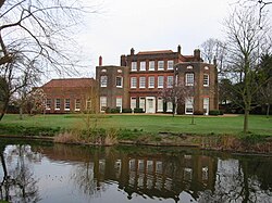
Langtons House, Hornchurch
• Motto
A good name endureth
Coat of arms of Hornchurch Urban District Council
Today part of
London Borough of Havering
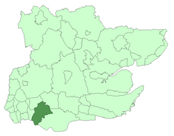
Hornchurch was a local government district in southwest Essex from 1926 to 1965, formed as an urban district for the civil parish of Hornchurch. It was greatly expanded in 1934 with the addition of Cranham, Great Warley, Rainham, Upminster and Wennington; and in 1936 by gaining North Ockendon. Hornchurch Urban District Council was based at Langtons House in Hornchurch from 1929. The district formed a suburb of London and with a population peaking at 131,014 in 1961, it was one of the largest districts of its type in England. It now forms the greater part of the London Borough of Havering in Greater London.
and 24 Related for: Hornchurch Urban District information
Hornchurch was a local government district in southwest Essex from 1926 to 1965, formed as an urbandistrict for the civil parish of Hornchurch. It was...
of London in the 20th century, Hornchurch significantly expanded and increased in population, becoming an urbandistrict in 1926 and has formed part of...
parish of Hornchurch, which became the Liberty of Havering. Most of the current area of Harold Wood became part of HornchurchUrbanDistrict in 1926. It...
The first election to HornchurchUrbanDistrict Council took place on 27 March 1926, ahead of the creation of the new urbandistrict on 1 April 1926. The...
The second election to HornchurchUrbanDistrict Council took place in April 1927. The election was for 6 of 13 seats on the council. The election increased...
The third election to HornchurchUrbanDistrict Council took place in April 1928. The election was for 4 of 13 seats on the council. The election increased...
significantly expanded and increased in population, becoming part of HornchurchUrbanDistrict in 1934, and has formed part of Greater London since 1965. The...
divide the parish between an expanded HornchurchUrbanDistrict and a new Thurrock UrbanDistrict. Purfleet UrbanDistrict Council took legal action in an attempt...
It is home to the Hornchurch F.C. and Havering Mayesbrook Athletics Club. The stadium was opened in 1956 by HornchurchUrbanDistrict Council. It was the...
the Hornchurch parish was removed from the rural district to become HornchurchUrbanDistrict and the parish council became HornchurchUrbanDistrict Council...
Cranham significantly increased in population, becoming part of HornchurchUrbanDistrict in 1934 and has formed part of Greater London since 1965. The...
Association opposed Hornchurch gaining urban powers. In 1926 the parish of Hornchurch was removed to form HornchurchUrbanDistrict and the parish of Dagenham...
public park. Langtons House was used as the council offices of HornchurchUrbanDistrict Council from 1929 to 1965. The house, built on the foundations...
following reform of local government in London, it merged with the HornchurchUrbanDistrict to form the London Borough of Havering, and was incorporated into...
combined area of the former Municipal Borough of Romford and HornchurchUrbanDistrict. The area was transferred from Essex to Greater London to become...
1963. The former area of the Municipal Borough of Romford and HornchurchUrbanDistrict, which had not previously been covered by the MPD but were now...
party has its origins in the Hornchurch Ratepayers' Association which contested elections to HornchurchUrbanDistrict Council since it was created in...
Park is a large public park in Hornchurch in the London Borough of Havering. It was created by HornchurchUrbanDistrict Council, partly on land donated...
protrusion of the Hornchurch civil parish. It was part of Romford Rural District until 1926 and was then formed part of HornchurchUrbanDistrict. Harold Park...
expanded in the 1960s by Dagenham Borough Council. Hornchurch Marshes were part of HornchurchUrbanDistrict from 1926 to 1965. In the 1950s a foundry was...
transferred to Greater London from Essex and combined with that of HornchurchUrbanDistrict to form the present-day London Borough of Havering. Romford Town...
 Global Information