Hong Kong Strategic Route and Exit Number System information
Trunk road numbering system in Hong Kong
Strategic Route and Exit Number System
Highway marker for Route 1
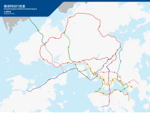
A map of all routes in Hong Kong
System information
Maintained by Transport Department
Length
231.3 km (143.7 mi)
Formed
2004; 20 years ago (2004)
Highway names
Route:
Route X
System links
Transport in Hong Kong
Routes
Roads and Streets
The Hong Kong Strategic Route and Exit Number System (Chinese: 香港主要幹線及出口編號系統) is a system adopted by the Transport Department of the Hong Kong Government to organise the major roads in the territory into routes 1 to 10 for the convenience of drivers. When the system was implemented in 2004, the government promoted it with a major public campaign, including the slogan "Remember the Numbers; Make Driving Easier" (Chinese: 認路記號碼,唔使路路查).
The system comprises ten major series of roads in Hong Kong, numbered routes 1 to 10, which can be classified into three categories: the three north-south routes, the six east-west routes and the New Territories Circular Road. The route numbers are displayed as black on yellow "road-shields" on overhead road signs.
Parts of the road system are limited-access roads, and a significant portion of these roads are expressways. The system also utilises exit numbering with the exits of each route are numbered sequentially; some exit numbers are suffixed with a letter. Exit numbers are indicated by white-in-black rectangular boxes on overhead and roadside signs.
and 15 Related for: Hong Kong Strategic Route and Exit Number System information
country's directional signage coloring system on these two types of roads. The HongKongStrategicRouteandExitNumberSystem states that the standard shield...
Tsing Ma Bridge is a bridge in HongKong. It is the world's 16th-longest span suspension bridge, and was the second longest at the time of its completion...
Cantonese Yale: ching1 kwai4 gung1 lou6) is a section of Route 3 in HongKong, previously known as Route 3 - Kwai Chung Section. From its junction with West...
177-metre (3,862 ft) long cable-stayed bridge in HongKong that spans from the northwest of Tsing Yi Island and Tuen Mun Road. It is near the Tsing Ma Bridge...
custody (AUC) and $4.9 trillion in assets under administration (AUA). HSBC traces its origin to a hong trading house in British HongKong. The bank was...
West Kowloon Highway is a section of Route 3 in HongKong, built as part of the Airport Core Programme. This dual-three-lane expressway runs for 4.2 km...
a dual-2 lane expressway in HongKong. It links Lion Rock Tunnel Road and Tai Po Road — Sha Tin, forming a part of Route 1. This 3.4 km road is mostly...
Yi and Stonecutters Island are located near Container Terminal 9 and Container Terminal 8, respectively. The bridge is part of HongKong'sRoute 8, connecting...
thoroughfare on the north shore of HongKong Island, HongKong. It links Shing Sai Road in Kennedy Town to the west and Harcourt Road in Admiralty to the...
first major road tunnel in HongKong, is a twin-bored toll tunnel, connecting Hin Tin, Sha Tin in the New Territories and New Kowloon near Kowloon Tong...
roadway in HongKong forming part of Route 8 linking Lantau Island to Tsing Yi, from which other roads lead to the urban areas of Kowloon and the rest of...
 Global Information