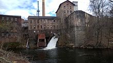
The Hockanum River flowing through a textile mill in Downtown Rockville, Connecticut.
The Hockanum River is a river in Connecticut. Hockanum is derived from the Native American Podunk people Algonquin language word meaning "hook-shaped", so named because of the course of the river.[1] The Hockanum neighborhood in East Hartford is named after it.
It rises at the outlet of Shenipsit Lake in Rockville, then flows through Vernon, Ellington, Manchester, and East Hartford. Its mouth on the Connecticut River is immediately north of the Charter Oak Bridge and south of and across from the mouth of the Park River.
The Hockanum River runs for about 22.6 miles (36.4 km)[2] until it spills into the Connecticut River. There is a popular paddling route that follows the river for 13 miles (21 km). It begins at the bridge at Pleasant View Drive, one mile west of Vernon Center, and continues to the Connecticut River. This river run is mostly quickwater with one Class II whitewater area that eventually fades to flatwater and tidal water at its mouth at the Connecticut River.
Historically used for industry, the river has in recent years had hiking trails and linear parks developed along its banks. The banks of the river are slowly being cleaned up after years of pollution and dumping.
^Gannett, Henry (1905). The Origin of Certain Place Names in the United States. Govt. Print. Off. pp. 158.
^U.S. Geological Survey. National Hydrography Dataset high-resolution flowline data. The National Map Archived 2012-03-29 at the Wayback Machine, accessed April 1, 2011
The HockanumRiver is a river in Connecticut. Hockanum is derived from the Native American Podunk people Algonquin language word meaning "hook-shaped"...
Hockanum can refer to some places in the United States: Hockanum (East Hartford), a neighborhood in East Hartford, Connecticut HockanumRiver, a river...
CT) Eightmile River (Hamburg, CT) Deep River (Deep River, CT) Salmon River (Moodus, CT) Mattabesset River (Middletown, CT) HockanumRiver (East Hartford...
884639°N 72.42611°W / 41.884639; -72.42611. It is the source of the HockanumRiver. Native American trails pass directly by Shenipsit Lake. The trails...
the region north of the HockanumRiver was generally known as Podunk in colonial times; that south of the river, as Hockanum; however, these are likely...
Salmon River Moodus River Blackledge River Jeremy River Sumner Brook Pameacha Creek Mattabesset River Coginchaug RiverHockanumRiver Tankerhoosen River Park...
Cos Cob: (Mohegan from Cassacubque) "high rocks" Hockanum: (Podunk) "hook" Shared with the HockanumRiver. Massapeag: (Mohegan) "place at the large cove"...
Hockanum Rural Historic District is a rural historic district along the Connecticut River in Hadley, Massachusetts. The district includes much of the...
set on 6.4 acres (2.6 ha) of land between West Main Street and the HockanumRiver, which historically provided its power. Its main building is a four-story...
to the north and Wilbur Cross Highway the south. To the east is the HockanumRiver, across from which is Wickham Park, mostly in Manchester. Mayberry Village...
embankment dam with masonry work on the eastern branch of the Farmington River in southwestern Barkhamsted, Connecticut and central Hartland, Connecticut...
height of land between the Connecticut River/Long Island Sound watershed to the west and the Merrimack River/Gulf of Maine watershed to the east. Water...
industrial area, occupying the lowest water privilege in the town on the HockanumRiver. It was located at the western end of West Main Street, at its junction...
Hampshire, United States, situated along the headwaters of the Connecticut River. They are accessed via the northernmost segment of U.S. Route 3, between...
spread over five acres at the confluence of the Bigelow Brook and HockanumRiver. Hilliard Mills is listed on the State of Connecticut Register of Historic...
located in the northeast corner of Vernon, roughly at the point where the HockanumRiver, the historic source of the mill's power, enters the town. It is a complex...
000 population. This section of the river is completely in the Hartford Metro area. Hartford East Hartford Hockanum Wethersfield Glastonbury South Glastonbury...
twin Case brothers both learned the papermaking trade in plants on the HockanumRiver. Recognizing business opportunities created by the American Civil War...
The Naugatuck River is a 40.2-mile-long (64.7 km) river in the U.S. state of Connecticut. Its waters carve out the Naugatuck River Valley in the western...
 Global Information