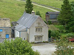
Hazlebadge is a civil parish within the Derbyshire Dales district, in the county of Derbyshire, England. Largely rural, Hazlebadge's population is reported with the population of neighbouring parishes for a total of 427 residents in 2011.[1] It is 143 miles (230 km) north west of London, 29 miles (47 km) north west of the county city of Derby, and 7 miles (11 km) east of the nearest market town of Chapel-en-le-Frith. Hazlebadge is wholly within the Peak District national park, and shares a border with the parishes of Abney and Abney Grange, Bradwell, Brough and Shatton, Great Hucklow as well as Little Hucklow.[2] There are four listed buildings in Hazlebadge.[3]
^ abcUK Census (2011). "Local Area Report – Great Hucklow Parish (E04002756)". Nomis. Office for National Statistics. Retrieved 6 October 2021.
^"Hazlebadge". Ordnance Survey.
^"Listed Buildings in Hazlebadge, Derbyshire Dales, Derbyshire". British Listed Buildings. Retrieved 19 September 2021.
Hazlebadge is a civil parish within the Derbyshire Dales district, in the county of Derbyshire, England. Largely rural, Hazlebadge's population is reported...
Hazlebadge is a civil parish in the Derbyshire Dales district of Derbyshire, England. The parish contains four listed buildings that are recorded in the...
property near Loxley, among other places both far and wide including Hazlebadge Hall, Peveril Castle and Haddon Hall. Mercia, to which Nottingham belonged...
buildings in Hassop Listed buildings in Hathersage Listed buildings in Hazlebadge Listed buildings in Highlow Listed buildings in Hognaston Listed buildings...
buildings in Hassop Listed buildings in Hathersage Listed buildings in Hazlebadge Listed buildings in Highlow Listed buildings in Hognaston Listed buildings...
earthworks and buried remains of buildings. Cop Low oval barrow Barrow Hazlebadge near Little Hucklow SK1662779134 Cop Rake and Moss Rake lead mines Mining...
 Global Information