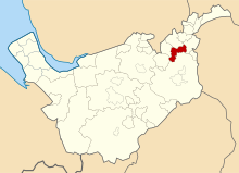
Hazel Grove and Bramhall UD within Cheshire in 1970
Area
• 1911
5,447
• 1961
5,990
Population
• 1901
7,934
• 1971
39,647
History
• Created
1900
• Abolished
1974
• Succeeded by
Metropolitan Borough of Stockport
Status
Urban district, Civil parish
Hazel Grove and Bramhall was a civil parish[1] and urban district[2] in north east Cheshire, England from 1900 to 1974.
It was created in 1900 covering, from Stockport Rural District, the former area of the civil parishes of:
Bosden
Bramhall
Norbury
Offerton
Torkington
In 1936, 903 acres (3.65 km2) were transferred to the County Borough of Stockport and 16 acres (65,000 m2) to Marple Urban District. In 1939 the former area of the Woodford civil parish was gained.[2]
The district was abolished in 1974, under the Local Government Act 1972, and its former area was transferred to Greater Manchester to be combined with that of other districts to form the present-day Metropolitan Borough of Stockport.[3]
^Vision of Britain Archived 2007-10-01 at the Wayback Machine - Hazel Grove and Bramhall parish (historic map Archived 2007-09-30 at the Wayback Machine)
^ abVision of Britain Archived 2007-09-30 at the Wayback Machine - Hazel Grove and Bramhall UD (historic map Archived 2007-10-01 at the Wayback Machine)
^Arnold-Baker, C., Local Government Act 1972, (1973)
and 18 Related for: Hazel Grove and Bramhall Urban District information
2°08′24″W / 53.367°N 2.140°W / 53.367; -2.140 HazelGroveandBramhall was a civil parish andurbandistrict in north east Cheshire, England from 1900 to...
it was purchased by John Henry Davies and then, in 1935, acquired by HazelGroveandBramhallUrbanDistrict Council. Following a local government reorganisation...
Australia is part of the Bramhall South Ward. The New House Farm area is to the north of Bramhalland extends into HazelGrove after crossing the Fred...
Rural District of Cheshire from 1894 to 1900. From 1900 to 1974, HazelGrove was part of the HazelGroveandBramhall civil parish andurbandistrict. Hazel...
Stockport and from the administrative county of Cheshire the urbandistricts of Bredbury and Romiley, Cheadle and Gatley, HazelGroveandBramhalland Marple...
1932 a new greyhound track was proposed and the Building Committee of the HazelGroveandBramhallUrbanDistrict Council passed the plans in January 1932...
1900 HazelGroveandBramhallUrbanDistrict was formed from five of the parishes in the rural district (Bosden, Bramhall, Norbury, Offerton, and Torkington)...
Machine East Bramhall; HazelGrove (part); and West Bramhall wards. Retrieved 2009-08-26 A Vision of Britain Through Time : Marple UrbanDistrict Retrieved...
comprising the urbandistricts of Cheadle and Gatley (previously part of Bucklow), HazelGroveandBramhall (previously part of Knutsford), Bredbury and Romiley...
in London and in 1974 elsewhere. They generally arose where former urbandistricts, municipal boroughs or county boroughs were abolished and where no successor...
This is a list of all the rural districts, urbandistrictsand municipal boroughs in England as they existed prior to the entry into force of the Local...
Woodford, Bramhalland Cheadle Hulme are relatively wealthy and 45% of the borough is green space, districts such as Edgeley, Adswood, Shaw Heath and Brinnington...
Bredbury and Romiley, Cheadle and Gatley, Hale, HazelGroveandBramhall, Longdendale, Marple and Wilmslow; (iii) the rural districts of Disley and Tintwistle;...
Macclesfield Altrincham Winsford Hyde Wilmslow Cheadle Hulme Congleton Bramhall Marple Stalybridge Knutsford Northwich The county is home to some of the...
 Global Information