Global Information Lookup Global Information

Harperley information


Harperley
Harperley Hotel
Harperley is located in County Durham
Harperley
Harperley
Location within County Durham
OS grid referenceNZ175535
Shire county
  • County Durham
Region
  • North East
CountryEngland
Sovereign stateUnited Kingdom
Post townDURHAM
Postcode districtDH9
PoliceDurham
FireCounty Durham and Darlington
AmbulanceNorth East
List of places
UK
England
County Durham
54°52′34″N 1°43′44″W / 54.876°N 1.729°W / 54.876; -1.729

Harperley is a small village in County Durham, England. It is situated between Tantobie to the north east, Tanfield Lea to the east, Stanley to the south, East Kyo to the south east and Catchgate, West Kyo and Annfield Plain to the west.

Harperley consists of two parts; the southern part (consisting of seven houses) is set around crossroads from which there is easy access to West Kyo, Catchgate, Annfield Plain and Stanley. The northern part (consisting of three houses and a farm) is grouped around the now derelict Harperley Hotel, a now closed public house formerly known locally for meals and hosting wedding functions. Due to local council ownership in the 1970s, it allegedly gained the nickname Ratepayer's Arms.

The grounds surrounding the Harperley Hotel used to be the site of a zoo (in the 1960s) and a children's playground (as late as the 1980s). A local stream called the Kyo Burn flows through the grounds, which lower down its course is known as Beamish Burn and later the River Team before it flows into the River Tyne.

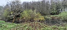
Harperley Pond sits 100 m east of the former hotel. Mallard Ducks, Moorhens and the occasional Heron have been sited here.

Harperley Pond, 100 m east of the former Harperley Hotel.

and 19 Related for: Harperley information

Request time (Page generated in 1.1176 seconds.)

Harperley

Last Update:

Harperley is a small village in County Durham, England. It is situated between Tantobie to the north east, Tanfield Lea to the east, Stanley to the south...

Word Count : 292

Harperley POW Camp 93

Last Update:

Harperley POW Camp 93 is a surviving purpose-built World War II Prisoner of War (PoW) camp built to accommodate up to 1,400 inmates at Fir Tree near Crook...

Word Count : 3301

Harperley railway station

Last Update:

Harperley railway station served the Harperley Hall Estate and the nearby hamlet of Low Harperley, close to the village of Fir Tree in County Durham,...

Word Count : 696

Weardale Railway

Last Update:

Stanhope Station Frosterley Station Kingfisher Halt Wolsingham Station Harperley Station (Currently Disused) Witton-le-Wear (Re-opened, Easter 2016) Wear...

Word Count : 2485

West Kyo

Last Update:

Bogs, the C2C and Kyo Pond. East Kyo is 15 minutes walk to the east. Harperley is 15 minutes walk to the north. The nearest large town is Stanley. The...

Word Count : 505

Stillington railway station

Last Update:

Johns Chapel Westgate-in-Weardale Eastgate Stanhope Frosterley Wolsingham Harperley Witton-le-Wear Wear Valley Junction Weardale Extension Railway Crawley...

Word Count : 164

List of places in County Durham

Last Update:

Hamsterley (Bishop Auckland), Hamsterley (Consett), Hardwick, Harelaw, Harperley, Harrowgate Hill, Harrowgate Villa, Hart, Hart Station, Hartburn, Hartlepool...

Word Count : 864

National Policing Improvement Agency

Last Update:

to construct major crime management scenarios and events in real time. Harperley Hall near Crook in County Durham, was the NPIA's specialist forensic training...

Word Count : 2024

High Stoop railway station

Last Update:

Johns Chapel Westgate-in-Weardale Eastgate Stanhope Frosterley Wolsingham Harperley Witton-le-Wear Wear Valley Junction Weardale Extension Railway Crawley...

Word Count : 186

East Kyo

Last Update:

to Annfield Plain, West Kyo (15 minutes walk to the west), Oxhill and Harperley. The hamlet of East Kyo consists of two farms and East Kyo House, a former...

Word Count : 115

Stockton Norton Road railway station

Last Update:

Johns Chapel Westgate-in-Weardale Eastgate Stanhope Frosterley Wolsingham Harperley Witton-le-Wear Wear Valley Junction Weardale Extension Railway Crawley...

Word Count : 213

Simpasture railway station

Last Update:

Johns Chapel Westgate-in-Weardale Eastgate Stanhope Frosterley Wolsingham Harperley Witton-le-Wear Wear Valley Junction Weardale Extension Railway Crawley...

Word Count : 249

Convoy ONS 5

Last Update:

U-628 5 May 1943 West Maximus  United States 5 5,561 U-264 5 May 1943 Harperley  United Kingdom 11 4,586 U-264 5 May 1943 Bristol City  United Kingdom...

Word Count : 3641

Yarm Depots railway station

Last Update:

Johns Chapel Westgate-in-Weardale Eastgate Stanhope Frosterley Wolsingham Harperley Witton-le-Wear Wear Valley Junction Weardale Extension Railway Crawley...

Word Count : 316

Bowes railway station

Last Update:

Johns Chapel Westgate-in-Weardale Eastgate Stanhope Frosterley Wolsingham Harperley Witton-le-Wear Wear Valley Junction Weardale Extension Railway Crawley...

Word Count : 386

List of crossings of the River Wear

Last Update:

1°46′20″W A68 Wear bridge  A68 road County Durham 54°40′15″N 1°46′34″W Harperley Footbridge  Weardale Way 54°42′21″N 1°49′12″W Wolsingham Rail Bridge ...

Word Count : 512

Lintz Green railway station

Last Update:

Johns Chapel Westgate-in-Weardale Eastgate Stanhope Frosterley Wolsingham Harperley Witton-le-Wear Wear Valley Junction Weardale Extension Railway Crawley...

Word Count : 398

Shotton Bridge railway station

Last Update:

Johns Chapel Westgate-in-Weardale Eastgate Stanhope Frosterley Wolsingham Harperley Witton-le-Wear Wear Valley Junction Weardale Extension Railway Crawley...

Word Count : 1321

Greatham railway station

Last Update:

Johns Chapel Westgate-in-Weardale Eastgate Stanhope Frosterley Wolsingham Harperley Witton-le-Wear Wear Valley Junction Weardale Extension Railway Crawley...

Word Count : 298

PDF Search Engine © AllGlobal.net