Global Information Lookup Global Information

Haripur Barabari information


Haripur Barabari
হরিপুর বড়বাড়ি
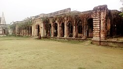
Haripur Barabari, Brahmanbaria, Bangladesh
Map
General information
Coordinates24°6′21.41″N 91°15′26.34″E / 24.1059472°N 91.2573167°E / 24.1059472; 91.2573167
Completed18th Century
LandlordKrishna Prasad Roy Choudhury

Haripur Barabari (Bengali: হরিপুর বড়বাড়ি) or Haripur Zamindar Bari (Bengali: হরিপুর জমিদার বাড়ি) is a palace in Horipur Union of Nasirnagar Upazila at Brahmanbaria district, Bangladesh earlier part of former British Bengal.[1] This palace founded by Jamindar Krishna Prasad Roy Choudhury(1870-1936) in eighteenth century.[2]This palace stands for the witness of Zamindar system of tax exploitation.

  1. ^ ধ্বংসের মুখে ১৭৫ বছরের প্রাচীন হরিপুর বড় বাড়ি. The Daily Ittefaq (in Bengali). 13 October 2013. Retrieved 2017-03-04.
  2. ^ "Nasirnagar Upazilla". Bangladesh National Portal.

and 4 Related for: Haripur Barabari information

Request time (Page generated in 0.7648 seconds.)

Haripur Barabari

Last Update:

Haripur Barabari (Bengali: হরিপুর বড়বাড়ি) or Haripur Zamindar Bari (Bengali: হরিপুর জমিদার বাড়ি) is a palace in Horipur Union of Nasirnagar Upazila...

Word Count : 694

Brahmanbaria District

Last Update:

near the mosque, supposedly the wives of Isa Khan. The 18th century Haripur Barabari was a residential palace located in Nasirnagar and many movies have...

Word Count : 1819

List of roads in Bangladesh

Last Update:

N513) - Kazirhat 3 1.9 37 N506 Mordern More (N5) - Lalbag more (N517) - Barabari (N509) - Kurigram 50 31 38 N507 Hatikamrul (N5, N405) - Banpara (N6) 51...

Word Count : 220

Baliadangi Upazila

Last Update:

Upazila is divided into eight union parishads: Amjankhore, Bara Palashbari, Barabari, Bhanor, Charol, Dhantala, Duosuo, and Paria. The union parishads are subdivided...

Word Count : 420

PDF Search Engine © AllGlobal.net