 Global Information
Hakskeenpan information
| Hakskeenpan | |
|---|---|
 | |
 Hakskeenpan | |
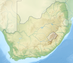
| Location | Dawid Kruiper Local Municipality, Northern Cape |
| Coordinates | 26°49′22.88″S 20°08′17.58″E / 26.8230222°S 20.1382167°E |
| Etymology | Afrikaans: Hakskeen, lit. 'Heel' |
| Basin countries | South Africa |
| Surface area | 140 square kilometres (54 sq mi) |
Hakskeenpan or Hakskeen Pan[1] is a mud and salt pan in the Kalahari Desert, in Southern Africa. It is located in the Dawid Kruiper Local Municipality region in the Northern Cape, South Africa, at 801 metres (2,628 ft) above sea level.[2] The pan covers an area of approximately 140 square kilometres (54 sq mi)[3]
- ^ "Hakskeen Pan in Upington, Northern Cape". www.sa-venues.com. Retrieved 11 December 2022.
- ^ "Elevation". elevationmap.net. Retrieved 16 February 2016.
- ^ Peter Jeremy Holmes (1 September 2012). Southern African Geomorphology: Recent Trends and New Directions. AFRICAN SUN MeDIA. pp. 158–. ISBN 978-1-920382-02-5.