Global Information Lookup Global Information

Gulf Islands National Seashore information


Gulf Islands National Seashore
IUCN category V (protected landscape/seascape)
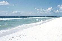
Gulf Islands National Seashore, near Pensacola
Map showing the location of Gulf Islands National Seashore
Gulf Islands National Seashore
Map showing the location of Gulf Islands National Seashore
Gulf Islands National Seashore (the United States)
LocationEscambia / Santa Rosa / Okaloosa counties, Florida; and Jackson / Harrison counties, Mississippi; USA
Nearest cityPensacola, FL (Fort Barrancas)
Navarre, FL (Santa Rosa Island area)
Gulf Breeze, FL (Naval Live Oaks area)
Destin, FL (Okaloosa Island area)
Pascagoula, MS (Mississippi area)
Coordinates30°21′52″N 86°58′3″W / 30.36444°N 86.96750°W / 30.36444; -86.96750
Area135,457.89 acres (548.1786 km2)
99,083.64 acres (40,097.73 ha) federal
EstablishedJanuary 8, 1971
Visitors8,277,857 (in 2023)[1]
Governing bodyU.S. National Park Service
WebsiteGulf Islands National Seashore
Gulf Islands National Seashore map

Gulf Islands National Seashore is an American National seashore that offers recreation opportunities and preserves natural and historic resources along the Gulf of Mexico barrier islands of Florida and Mississippi. In 2023, it was the fifth-most visited unit of the National Park Service.

The protected regions include mainland areas and parts of seven islands. Some islands along the Alabama coast were originally considered for inclusion, but none are part of the National Seashore.

The color of the sand in the region is exceptionally white, as seen in this 1957 photo at Pensacola Beach, Florida, adjacent to the protected area designated in 1971.

The Florida District of the seashore features offshore barrier islands with sparkling white quartz sand beaches (along miles of undeveloped land), historic fortifications, and nature trails. The Perdido Key Historic District preserves shore batteries active in World War I and World War II. Mainland features near Pensacola, Florida, include the Naval Live Oaks Reservation, beaches, and military forts. All Florida areas are accessible by automobile.

The Mississippi District of the seashore features natural beaches, historic sites, wildlife sanctuaries, islands accessible only by boat, bayous, nature trails, picnic areas, and campgrounds. The Davis Bayou Area is the only portion of the National Seashore in Mississippi that is accessible by automobile. Petit Bois, Horn, East Ship, West Ship, and Cat islands are accessible only by boat. The 4,080 acres (16.5 km2) Gulf Islands Wilderness offers special protection within the seashore to parts of Petit Bois Island and Horn Island, Mississippi.

Considerable damage to public infrastructure occurred as a result of storms during the 2004 and 2005 Atlantic hurricane seasons. In subsequent years, infrastructure was fully repaired. All roadways, parking areas, campgrounds, and visitor centers have been repaired and are fully operational. A few trails and associated boardwalks and dune crossovers were still under repair as of late 2010, especially near the Fort Pickens campground.

Hurricane Sally hit the area in September 2020 causing massive damage to the Gulf Islands Seashores. Perdido Key was hit with flooding waters that flattened out some of the dunes along Perdido Key. Johnson Beach National Seashore, part of the Gulf Islands National Seashore at the east end of the island, was hit particularly hard. Many of the dunes were flattened and the end of the island was gorged forming 3 small isolated islands off the tip.[2] Restoration projects bring in sand and vegetation to restore storm damage, though it can be a long process with subsequent storms and strong winds.

Entrance fees are charged at the entrance to the Fort Pickens area at Pensacola Beach, as well as the Johnson Beach Area at Perdido Key in Florida. The typical automobile entrance fee is US$25, good for seven days. Annual passes can be purchased for US$45.

  1. ^ "Annual Park Ranking Report for Recreation Visits in: 2023". nps.gov. National Park Service. Retrieved March 23, 2024.
  2. ^ Robinson, Kevin. "Perdido Keys?! Hurricane Sally cuts eastern tip of barrier island into three sections". Pensacola News Journal. Retrieved 2021-05-29.

and 21 Related for: Gulf Islands National Seashore information

Request time (Page generated in 1.0513 seconds.)

Gulf Islands National Seashore

Last Update:

Gulf Islands National Seashore is an American National seashore that offers recreation opportunities and preserves natural and historic resources along...

Word Count : 1385

List of national lakeshores and seashores of the United States

Last Update:

have two. The largest national seashore or lakeshore is Gulf Islands, at over 137,000 acres (550 km2); the smallest is Fire Island, at 19,579 acres (79...

Word Count : 1533

Padre Island National Seashore

Last Update:

Padre Island National Seashore (PINS) is a national seashore located on Padre Island off the coast of South Texas. In contrast to South Padre Island, known...

Word Count : 2295

Ship Island

Last Update:

island is included in the Gulf Islands National Seashore. Having the only deep-water harbor between Mobile Bay and the Mississippi River, the island served...

Word Count : 2012

Fire Island National Seashore

Last Update:

Fire Island National Seashore (FINS) is a United States National Seashore that protects a 26-mile (42 km) section of Fire Island, an approximately 30-mile...

Word Count : 1192

Fort Pickens

Last Update:

Fort Pickens is included within the Gulf Islands National Seashore, and as such, is administered by the National Park Service. Fort Pickens was part of...

Word Count : 2178

Perdido Key

Last Update:

it from the mainland. The eastern part of the island forms part of the Gulf Islands National Seashore, which includes the Perdido Key Historic District...

Word Count : 2573

Petit Bois Island

Last Update:

Mississippi. Since 1971 it has been a part of Gulf Islands National Seashore, administered by the U.S. National Park Service. According to the United States...

Word Count : 385

Naval Live Oaks Reservation

Last Update:

Reservation or Deer Point Plantation) is part of the Gulf Islands National Seashore and is near Gulf Breeze, Florida. It was purchased by the U.S. government...

Word Count : 449

Pensacola Pass

Last Update:

condominiums. Santa Rosa Island and the eastern part of Perdido Key adjacent to Pensacola Pass are units of the Gulf Islands National Seashore, and remain largely...

Word Count : 2204

Canaveral National Seashore

Last Update:

The Canaveral National Seashore (CANA) is a National Seashore located between New Smyrna Beach and Titusville, Florida, in Volusia and Brevard Counties...

Word Count : 1457

Florida panhandle

Last Update:

barrier islands fronting the Gulf of Mexico. According to the National Park Service: The stunning sugar-white beaches of Gulf Islands National Seashore are...

Word Count : 3849

Florida Trail

Last Update:

from Big Cypress National Preserve (between Miami and Naples, along the Tamiami Trail) to Fort Pickens at Gulf Islands National Seashore, Pensacola Beach...

Word Count : 1237

Fort McRee

Last Update:

with Fort Pickens, was turned over to the National Park Service and became part of Gulf Islands National Seashore. This ended nearly 140 years of military...

Word Count : 2051

Mississippi Sound

Last Update:

Petit Bois Islands are part of the National Park Service's Gulf Islands National Seashore. Those islands separate the sound from the Gulf of Mexico. The...

Word Count : 675

Pensacola Bay

Last Update:

end of the peninsula. The Gulf Islands National Seashore includes Santa Rosa Island, and encloses part of the bay. The Gulf Intracoastal Waterway runs through...

Word Count : 466

Battle of Santa Rosa Island

Last Update:

Fort Pickens and the battle site are preserved within the Gulf Islands National Seashore. Department of Florida: Col. Harvey Brown 6th New York Zouave...

Word Count : 769

Fort Barrancas

Last Update:

Congress authorized the establishment of the Gulf Islands National Seashore, to be managed by the National Park Service. Fort Barrancas was included in...

Word Count : 1938

Deepwater Horizon oil spill

Last Update:

Intracoastal Waterway and on Pensacola Beach and the Gulf Islands National Seashore. In late June, oil reached Gulf Park Estates, its first appearance in Mississippi...

Word Count : 22739

Padre Island

Last Update:

food. Islands portal Texas portal List of islands of the United States List of islands of the United States by area Padre Island National Seashore "Ballí...

Word Count : 1436

Archeological Properties of the Naval Live Oaks Reservation MPS

Last Update:

Properties of the Naval Live Oaks Reservation, Gulf Breeze, Florida - Multiple Property Documentation Form". National Park Service. Retrieved September 15, 2014...

Word Count : 54

PDF Search Engine © AllGlobal.net