1980 U.S. Geological Survey Topographical map of a portion of Independence Missouri with a blurry red line superimposed, showing the route of the ancient "Great Osage Trail" which after 1825 was known as the first section of the Santa Fe Trail, destination New Mexico and Mexico.
The Great Osage Trail, also known as the Osage Trace or the Kaw Trace, was one of the more well-known Native American trails through the countryside of the Midwest and Plains States of the U.S., pathways blazed by herds of buffalo or other migrating wildlife (Medicine Trails).
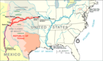
Map of most of the Santa Fe Trail in 1845. A more detailed map[1] produced by the National Park Service shows the starting point in central Missouri, further east of the Kansas City Metropolitan Area than is shown in this map.
The Osage Indians and other tribes traveled among a variety of routes later named "Osage Trails" by European settlers; the famous Route 66 through southern Missouri Ozarks follows the route of one such "Osage Trail" and U.S. Route 24 through central Missouri follows the route (from Franklin, Missouri westward) of the "Great Osage Trail", which in 1825 became known as the first phase of the Santa Fe Trail, extending from central Missouri (near Franklin and Boonville, Missouri) westward shadowing the route of the Missouri River, then turning southwestward through Independence, Missouri, into Kansas, Colorado, Santa Fe, New Mexico, and "Old" Mexico. From an 1881 History of Jackson County, Missouri,
"The Santa Fe trade first began at Old Franklin, a little town on the Missouri River... and continued from this point till the year 1831, when it sprung up at Independence. The town of Independence being a hundred miles further west, and near the great bend of the Missouri River, it was thought to be a more favorable place for fitting out caravans for Mexico, since also the route could be made from Franklin to Independence much better by water than land. At Independence the bulk of the trade continued till about the years 1838-40, when it began at Westport, and subsequently at Westport Landing (now Kansas City)...."[2]
^"Santa Fe National Historic Trail Map" (PDF). National Park Service. Retrieved 2008-07-20.
^p. 170, The History of Jackson county, Missouri: containing a history of the county, its cities, towns, etc.,... Union Historical Society, 1881.
The GreatOsageTrail, also known as the Osage Trace or the Kaw Trace, was one of the more well-known Native American trails through the countryside of...
who registered 160 acres (65 ha) of land located adjacent to the GreatOsageTrail, the only open road for traveling farther west. After a cabin, a barn...
The Oregon Trail was a 2,170-mile (3,490 km) east–west, large-wheeled wagon route and emigrant trail in the United States that connected the Missouri...
known by this name. It followed an old Native American route, the GreatOsageTrail across the Ozarks and became a road along a telegraph line from St...
headwaters of the Osage River near Nevada, Missouri. Fort Osage formally was closed in 1822, but remained a landmark on the Santa Fe Trail and a transit point...
Boone County, Missouri List of cemeteries in Boone County, Missouri GreatOsageTrail "History of region" Archived 2013-10-05 at the Wayback Machine, Boonslick...
the Great Salt Plains gave the Osages a surplus of salt to trade with other tribes. According to Burns, the Osage were firmly in control of the Great Salt...
The Osage Railway (/ˈoʊseɪdʒ/ OH-sayj) was incorporated in 1921 to accommodate traffic from the oil fields located in the Osage Nation. The first part...
survey of the trail. They followed a route from Fort Osage to Santa Fe. During the expedition he was an interpreter for a treaty with the Osage signed on...
The Trail of Tears was the forced displacement of approximately 60,000 people of the "Five Civilized Tribes" between 1830 and 1850, and the additional...
Becknell followed portions of the existing Osage Trace and the Medicine Trails. West of Franklin, the trail crossed the Missouri near Arrow Rock, after...
the Great Plains that stretched from Texas to Manitoba. The preserve is located at the southern end of the Flint Hills, also known as the Osage Hills...
son of a Kansas cowboy and an Osage-Lakota woman born on the Pine Ridge Indian Reservation in South Dakota. His great-grandfather, Henry Chatillon, guided...
and Eastern Shelby counties. OsageTrails is located in Chariton, Saline, Pettis and Benton counties. In addition, the Great Rivers Council has two mobile...
Kansas City, Missouri Olathe, Kansas Osage City, Kansas Council Grove, Kansas Marion, Kansas McPherson, Kansas Great Bend, Kansas Dodge City, Kansas Garden...
Trail State Park is a state park in the U.S. state of Missouri that contains the Katy Trail, the country's longest continuous recreational rail trail...
of MaNu is White Buffalo, the Osage word for white also meant Spirit, so MaNu means Spirit Buffalo. The NeTseO Trails Council serves Scouts in Texas...
George operated an Indian trading post at Fort Osage on the Missouri River. He was the factor of Fort Osage, which meant he was not only a fur trader, but...
490 km) Oregon Trail connected various towns along the Missouri River to Oregon's Willamette Valley. It was used during the 19th century by Great Plains pioneers...
 Global Information