 Global Information
Grande Ronde River information
| Grande Ronde River | |
|---|---|
 The Grande Ronde River just above Wildcat Creek, near Troy, Oregon | |
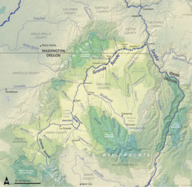 Map of the Grande Ronde River watershed | |
 Location of the mouth of the Grande Ronde River in Washington | |
| Location | |
| Country | United States |
| State | Oregon, Washington |
| Counties | Union and Wallowa counties in Oregon, Asotin County in Washington |
| Cities | La Grande, Elgin |
| Physical characteristics | |
| Source | Blue Mountains |
| • location | Anthony Lakes, Union County, Oregon |
| • coordinates | 44°57′34″N 118°15′38″W / 44.95944°N 118.26056°W[1] |
| • elevation | 7,460 ft (2,270 m)[2] |
| Mouth | Snake River |
• location | Rogersburg, Asotin County, Washington |
• coordinates | 46°4′49″N 116°58′47″W / 46.08028°N 116.97972°W[1] |
• elevation | 820 ft (250 m)[1] |
| Length | 210 mi (340 km)[3] |
| Basin size | 4,105 sq mi (10,630 km2)[3] |
| Discharge | |
| • location | near Troy, OR, about 45.3 mi (72.9 km) from the mouth[4] |
| • average | 3,016 cu ft/s (85.4 m3/s) |
| • minimum | 344 cu ft/s (9.7 m3/s) |
| • maximum | 51,800 cu ft/s (1,470 m3/s) |
| Basin features | |
| Tributaries | |
| • left | Wenaha River |
| • right | Catherine Creek, Wallowa River, Joseph Creek |
National Wild and Scenic River | |
| Type | Wild, Recreational |
| Designated | October 28, 1988 |
The Grande Ronde River (/ɡrænd rɑːnd/ or, less commonly, /ɡrænd raʊnd/) is a 210-mile (340 km) long[3] tributary of the Snake River, flowing through northeast Oregon and southeast Washington in the United States. Its watershed is situated in the eastern Columbia Plateau, bounded by the Blue Mountains and Wallowa Mountains to the west of Hells Canyon. The river flows generally northeast from its forested headwaters west of La Grande, Oregon, through the agricultural Grande Ronde Valley in its middle course, and through rugged canyons cut from ancient basalt lava flows in its lower course. While it joins the Snake River upstream of Asotin, Washington, more than 90 percent of the river's watershed is in Oregon.
The river was used for centuries by multiple Native American tribes, who fished, gathered and hunted across much of the watershed and convened in the Grande Ronde Valley for trade. European exploration began with the fur trade in the early 1800s; later, the Grande Ronde Valley provided a key resting point along the Oregon Trail. By the 1850s, the wave of settlement had spread to northeast Oregon, and the river was the scene of several conflicts, including the 1856 Grande Ronde massacre. Nearby gold strikes drove emerging farming and logging industries in the Grande Ronde region, and by the 1880s most indigenous peoples had been forced away from the area and onto reservations, though several tribes maintain subsistence fishing rights along the river.
While the Grande Ronde and Wallowa Valleys developed into productive farming areas, further efforts to regulate and dam the river in the 20th century proved unsuccessful. Due to its free-flowing nature, the river provides a significant amount of spawning habitat for anadromous fish (salmon and steelhead) in the Columbia River system. These populations have declined due to the building of dams downstream on the Columbia and Snake Rivers, as well as habitat degradation in the Grande Ronde watershed. Despite efforts to protect and restore aquatic habitat, anadromous fish populations in the 21st century remain much lower than historical levels.
About 44 miles (71 km) of the Grande Ronde in Oregon are federally protected as a National Wild and Scenic River, in addition to parts of several tributaries including the Wallowa and Wenaha Rivers. Much of the Wild and Scenic section in Oregon, as well as the lowermost stretches of the river in Washington, can only be reached by water. The river's scenic canyons, undeveloped surroundings and abundant wildlife make it a popular location for sport fishing, hunting, wildlife viewing, and boating.
- ^ a b c "Grande Ronde River". Geographic Names Information System. United States Geological Survey, United States Department of the Interior. September 10, 1979. Retrieved February 20, 2024.
- ^ Cite error: The named reference
USGS Anthony Lakeswas invoked but never defined (see the help page). - ^ a b c "National Hydrography Dataset high-resolution flowline data from The National Map". U.S. Geological Survey. Retrieved December 15, 2023.
- ^ "USGS Gage #13333000 Grande Ronde River at Troy, OR: Water-Data Report 2023". National Water Information System. U.S. Geological Survey. 2023. Retrieved January 15, 2024.