East Chicago, 10 miles from the headwaters, Lake County, Indiana
• elevation
577 ft (176 m)
Length
13.0 mi (20.9 km)
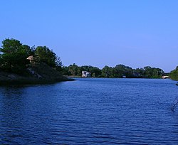
The Grand Calumet River is a 13.0-mile-long (20.9 km)[3] river that flows primarily into Lake Michigan. Originating in Miller Beach in Gary, it flows through the cities of Gary, East Chicago and Hammond, as well as Calumet City and Burnham on the Illinois side. The majority of the river's flow drains into Lake Michigan via the Indiana Harbor and Ship Canal, sending about 1,500 cubic feet (42 m3) per second of water into the lake. A smaller part of the flow, at the river's western end, enters the Calumet River, and through the Illinois ultimately drains into the Mississippi River.
Today, a large portion of the river's flow originates as municipal and industrial effluent, cooling and process water and storm water overflows. Although discharges have been reduced, a number of contaminants continue to impair the area. The river is among the country's most severely polluted,[4] and as of 2015 was in the late stages of a major dredging project to remove thousands of tons of contaminated sediment and rehabilitate the river ecosystem.[5]
^McCafferty (2008), pp. 17–19.
^ ab"Grand Calumet River". Geographic Names Information System (GNIS). United States Geological Survey. January 15, 1980. Retrieved February 1, 2015.
^"National Hydrography Dataset High-Resolution Flowline Data". The National Map. United States Geological Survey. Archived from the original on March 29, 2012. Retrieved May 19, 2011.
^Lydersen, Kari (January 26, 2013). "Grand Calumet River Delivers Toxic Load to Lake Michigan". Chicago: WBEZ. Retrieved February 2, 2015.
^Cite error: The named reference legacy was invoked but never defined (see the help page).
and 19 Related for: Grand Calumet River information
The GrandCalumetRiver is a 13.0-mile-long (20.9 km) river that flows primarily into Lake Michigan. Originating in Miller Beach in Gary, it flows through...
and the city of Gary, Indiana. Historically, the Little CalumetRiver and the GrandCalumetRiver were one, the former flowing west from Indiana into Illinois...
River Salt Creek GrandCalumetRiver (through Indiana Harbor and Ship Canal and the CalumetRiver in Illinois) Little CalumetRiver (through Indiana Harbor...
45°W / 41.55; -87.45 The Calumet Region is the geographic area drained by the GrandCalumetRiver and the Little CalumetRiver of northeastern Illinois...
shore of Lake Michigan, in East Chicago, Indiana, which connects the GrandCalumetRiver to Lake Michigan. It consists of two branch canals, the 1.25 miles...
ill on the Mississippi River. According to local tradition, Marquette camped for a night at the mouth of the GrandCalumetRiver in present-day Marquette...
Lake Michigan. In the northwest part of the state, it includes the GrandCalumetRiver area in Lake and Porter counties, and includes the cities of Gary...
Hegewisch neighborhood and, after crossing the Bishop Ford Freeway and the CalumetRiver, converges with the Metra Electric line south of Kensington/115th Street...
Arm Little CalumetRiver, also known as the Little CalumetRiver East Branch, is a 22.1-mile-long (35.6 km) portion of the Little CalumetRiver that begins...
southern parts are divided by the GrandCalumetRiver, including the westernmost of the three lagoons that mark the river's modern-day headwaters and former...
square feet) of storage. Lake Calumet terminal: located at the union of the GrandCalumetRiver and Little CalumetRiver 6 miles (9.7 km) inland from Lake...
groundwater aquifer, the Calumet Aquifer provides water to local surface waterways, including the GrandCalumetRiver and Little CalumetRiver. The contributions...
Steel Corporation. It is located east of Grant Street, south of the GrandCalumetRiver, north of 9th Avenue, and west of Interstate 65. Downtown West borders...
include: Cal-Sag Channel CalumetRiver Chicago River Chicago Sanitary & Ship Canal GrandCalumetRiver (partial) Little CalumetRiver (partial) North Shore...
tollway travels south through Hammond and turns east to follow the GrandCalumetRiver through northern Gary, where it intersects US 41 and US 12. I-90...
commonly referred to as "The Calumet Region". The name comes from the fact that the GrandCalumetRiver and Little Calumetrivers run through the area. These...
 Global Information