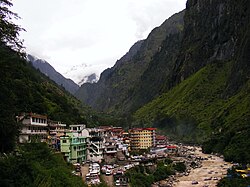
Govindghat is a town in Chamoli district, Uttarakhand, India, located at the confluence of the Alaknanda and Lakshman Ganga rivers. It lies around roughly 22 kilometres (14 mi) from Joshimath on NH58 at an altitude of 6,000 feet (1,800 metres). It is the roadhead on the way to Shree Badrinathji yatra - One of the important places of worship of Hindus and the starting point for trekking to Hemkund Sahib and Valley of Flowers.[1] Hundreds of people, mostly Hindu pilgrims to Shree Badrinathji and Sikh pilgrims on way to the holy shrine of Shree Hemkund Sahibji and occasional tourists to the Valley of Flowers, arrive here every day.
Govindghat, as seen after crossing Alaknanda River
The gurudwara, located on the right bank of the Alaknanda River, is the most important landmark in the area. It also provides accommodation to pilgrims. The local market has many hotels, guest houses and restaurants. The economy thrives on the traveling season, which begins at the end of May and lasts until the end of September.
^"Joshimath way cleared, pilgrims move ahead". The Times of India. 11 July 2004. Archived from the original on 15 June 2013. Retrieved 5 June 2013.
Govindghat is a town in Chamoli district, Uttarakhand, India, located at the confluence of the Alaknanda and Lakshman Ganga rivers. It lies around roughly...
at an elevation of 4,572 metres (15,000 feet). It is approached from Govindghat on the Rishikesh-Badrinath highway. The main town near Gobindghat is Joshimath...
can take the train to Haridwar and then travel by bus to Govindghat via Rishikesh. Govindghat is approximately 24 km before another important destination...
which forms Lakshman Ganga, that later meets the river Alaknanda at Govindghat. It is the last human habitation in the Ghangaria valley. This place is...
as the Lakshman Ganga. The latter merges with the Alaknanda River at Govindghat. The Pushpawati drains the Valley of Flowers. The glaciated upper valley...
Pushpawati River in Ghangaria. It then forms a Tributary to Alaknanda in Govindghat. Valley of Flowers "Hemkund Sahib". www.gmvnl.com. Archived from the original...
originated from Tipra glacier and Hemkund Sahib joins Alaknanda River at Govindghat after merging with River Pushpawati at Ghangaria. Dhauliganga meets at...
Number Baithak Name Location Town/City District State Coordinates Notes 1 Govindghat Gokul Mathura Mathura Uttar Pradesh 27°26′25″N 77°42′48″E / 27.4402643°N...
Flowers. The approach from Ghangaria is a little easier but longer. From Govindghat, there is an 18 km bridle path which runs through the Bhyundar valley...
reconnaissance and carried out air evacuation of people stranded along Govindghat-Badrinath road, track from Ghagriya to Hemkund to Badrinath and Ghagriya...
Ghagharia and became known as Lakshman Ganga that later joins Alaknanda at Govindghat. "Asia, India—Garhwal, Nilgiri Parbat Attempt and Ascent". American Alpine...
 Global Information