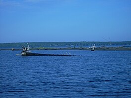
Goulais Bay is a bay of Ontario in Canada.[1] It is part of Whitefish Bay which in turn is a large bay of Lake Superior. Goulais Point, on the southernmost tip of the peninsula that separates the bay from Batchawana Bay just to the north and from Whitefish Bay to the west, marks the northern entrance of Goulais Bay. North Gros Cap is the rock point that forms the bay's southern limit.[2]
The dispersed rural community of Goulais Bay is near the mouth of the Goulais River that empties into the bay's east side.[3] On the western shore of the bay is the community of Goulais Mission.[4]
^"Goulais Bay". Geographical Names Data Base. Natural Resources Canada.
^United States War Dept. (1894). Annual Report of the Secretary of War. U.S. Government Printing Office. p. 3408. Archived from the original on 26 September 2018. Retrieved 26 September 2018.
^"Goulais Bay (community)". Geographical Names Data Base. Natural Resources Canada.
^"Goulais Mission". Geographical Names Data Base. Natural Resources Canada.
GoulaisBay is a bay of Ontario in Canada. It is part of Whitefish Bay which in turn is a large bay of Lake Superior. Goulais Point, on the southernmost...
to move to Goulais Mission. On 8 January 1979, the band council paid the Crown $365.20 to purchase 6.47 km2 of land in and around Goulais Mission. It...
Bellevue, Bourdage Corner, GoulaisBay, Goulais River, Karalash Corners, Kirby's Corner, and Sand Bay. In the community of GoulaisBay, on the grounds of Our...
Goulais can refer to: Places, all in Ontario, Canada: GoulaisBayGoulais River GoulaisBay 15A, a First Nations reserve in Algoma District Goulais Bay...
Crown $365.20 to purchase 6.47 km2 of land in and around Goulais Mission. This became the GoulaisBay 15A reserve. In 1982, the band filed a land claim to...
GoulaisBay 15C was a First Nation reserve within Prince Township, Ontario. This 5-acre tract of land was given to the Batchewana First Nation after Whitefish...
The Goulais River (Pronounced: goo-lee) is a river in northern Ontario, Canada, which rises in the Algoma highlands and empties into GoulaisBay on eastern...
Fitzgerald. Ile Parisienne Batchawana Bay - smaller sub-bay of Whitefish BayGoulaisBay - smaller sub-bay of Whitefish Bay Point Iroquois Light Sandy Islands...
parentheses. North Part (incl. local services boards of Aweres, Batchawana Bay, Goulais and District, Hawk Junction, Missanabie, Peace Tree, Searchmont and Wharncliffe...
Batchawana Bay, Lake Superior (live released). Lake sturgeon. Juvenile lake sturgeon GoulaisBay, Lake Superior. Juvenile lake sturgeon GoulaisBay, Lake Superior...
Batchawana BayGoulais and District (includes Bellevue, Bourdage Corner, GoulaisBay, Goulais River, Karalash Corners, Kirby's Corner and Sand Bay) Hawk Junction...
from Sandusky and Port Clinton to Put-in-Bay and Kelly's Island. The Miller Ferry from Catawba Island to Put-In-Bay and Middle Bass Island, the Kellys Island...
Chicago, Detroit, Toledo, Cleveland, Two Harbors, Hamilton and Thunder Bay. Shipping channels separate upbound traffic from downbound traffic. The upbound...
several other islands, a unique bog dune ecosystem can be found near deep bays and enclosed lagoons. According to the National Park Service, "One of the...
Toronto Bay, chosen as the site of the Upper Canada capital for its strategic harbor. Other prominent examples include Hamilton Harbour, Irondequoit Bay, Presqu'ile...
1859 at Gros Cap between the "Chiefs and Warriors of Batchewananny Bay and GoulaisBay Band of Indians", and the Crown. The chiefs and warriors agreed to...
extends northwesterly for 18.3 kilometres (11.4 mi) to the community of GoulaisBay. It passes through the communities of Kirby's Corner and Bourdage Corner...
Georgia, the Mackenzie River basin in Canada, Ohio Illinois, the Hudson Bay, some lakes throughout Montana, and the Great Lakes. They can also be found...
Georgian Bay TP Georgian Bluffs TP Georgina T Gillies TP Ginoogaming First Nation R Goderich T Gordon/Barrie Island TP Gore Bay T GoulaisBay R Gravenhurst...
Retrieved July 30, 2021. Reserve, settlement or village details for Allison Bay 219 Reserve at Indigenous and Northern Affairs Canada. Retrieved July 30...
Thunder Bay and Winnipeg. By June 1931, planning for the route of the highway was complete, and work underway on the new link between Thunder Bay and Winnipeg...
people. GoulaisBay - adjacent bay to the south "Batchawana Bay". Geographical Names Data Base. Natural Resources Canada. Retrieved 2018-07-01. (bay) Boyle...
located on the grounds of Our Lady of Sorrows Roman Catholic Church (GoulaisBay, Ontario), which was built by Baraga A memorial sculpture of him by Jack...
Highways. 1958. North Bay inset. Ontario Road Map (Map). Cartography by C.P. Robins. Ontario Department of Highways. 1959. North Bay inset. Ministry of Transportation...
Whitefish Island in the St. Marys River, Obadjiwan 15E at Batchawana Bay, and at GoulaisBay 15A. None of these areas are reserves under the 1850 Robinson Treaty...
 Global Information