 Global Information
Gormire Lake information
| Gormire Lake | |
|---|---|
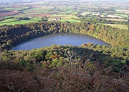 Gormire Lake, taken from Whitestone Cliff looking west across the Vale of York. | |
 Gormire Lake | |
| Coordinates | 54°14′31.3″N 1°13′47.4″W / 54.242028°N 1.229833°W |
| Type | Lake |
| Primary inflows | None |
| Primary outflows | None |
| Catchment area | 74.7 acres (30.25 ha)[1] |
| Basin countries | England |
| Surface area | 16 acres (6.4 ha)[2] |
| Max. depth | 21 feet (6.5 m)[3] |
| Shore length1 | 0.6 miles (0.97 km) |
| Surface elevation | 509 feet (155 m) |
| 1 Shore length is not a well-defined measure. | |
Gormire Lake is a natural lowland lake that lies at the foot of Whitestone Cliff, a western escarpment of the Hambleton Hills in the North York Moors National Park. The lake is 1.2 miles (2 km) east of the village of Sutton-under-Whitestonecliffe in North Yorkshire, England.[4] Gormire has no inflow or major outflow of water. It is thought to be fed by an underground spring and drained by a limestone channel[5] so the water finds a way out through the base of the cliff face to the east of the lake.[6] The lake is also known as the White Mere,[7] Lake Gormire, or more simply, Gormire. The name Gormire translates as filthy swamp.[8]
The lake was formed over 20,000 years ago by glacial erosion.[9] When an ice sheet pushed its way between the Pennines and the North York Moors, it bulldozed the soft earth away and carved the cliffs at Whitestone and in turn the mud left over stopped the water's egress and formed the glacial lake.[10] Gormire Lake was a result of this process and is fourth largest of the natural lakes in Yorkshire (the other three being Hornsea Mere, Malham Tarn and Semerwater).[11] The lake was first designated as an Site of Special Scientific Interest (SSSI) in 1954; however, in 1985 the area surrounding the lake was incorporated into the SSSI status with the new area being 133.5 acres (54.03 ha).[12] The new designation incorporates the broadleaf woodlands of Garbutt Wood which encroach right up to the water's edge.[13]
The lake is the setting of several myths; one being of a knight known as Sir Harry Scriven who conned the Abbot of Rievaulx Abbey into letting him ride his horse (a white mare, the so called derivation of White Mare Cliff (another name for Whitestonecliff)). The knight and the abbot rode on from an inn and as they did so, it turned into a race. The abbot then changed into the devil, which caused such panic in the knight that he couldn't stop the horse and himself plunging into Gormire Lake from the clifftop. The 'devil' was then seen to jump into the lake after them and the boiling effect of the devil in the water is what is said to have caused the darkness of the lake to this day.[14]
Other myths are that the lake is bottomless,[15] that the bottom of the lake is the entrance to hell, there is submerged village underneath the water and that a goose once disappeared in the lake to emerge in a well at Kirkbymoorside stripped of all its feathers.[16]
Gormire Lake is popular with wild swimmers as it has no streams feeding it so there is very little current and the waters are described as being 'warm'.[9] Swimmers have reported that it is seething with leeches.[17] The Times named the lake as one of the 20 best lakes and rivers in Britain for wild swimming.[18]
- ^ "Gormire Lake". Catchment Data Explorer. Environment Agency. Retrieved 22 August 2016.
- ^ "Gormire Lake". British Lakes. Retrieved 22 August 2016.
- ^ "MOLECULAR MARKER RECORDS OF LAND USE CHANGE" (PDF). repository.liv.ac.uk. Liverpool University. p. 5. Retrieved 22 August 2016.
- ^ "100" (Map). Malton & Pickering (C3 ed.). 1:50,000. Landranger. Ordnance Survey. 2011. ISBN 9780319261989.
- ^ Priestley, Mike (2 March 2007). "Lake Gormire, Sutton Bank". Telegraph and Argus. Retrieved 22 August 2016.
- ^ "Felixkirk". Genuki. Retrieved 22 August 2016.
- ^ Walker, Peter N (1990). Folk tales from the North York Moors. London: Hale. p. 153. ISBN 9780709039754.
- ^ Bagshaw, Mike (2014). North Yorkshire Moors (Slow Travel). Chalfont St Peter: Bradt. p. 27. ISBN 978 1 84162 548 5.
- ^ a b Start, Daniel (14 July 2013). "Time to take the plunge". The Yorkshire Post. Retrieved 22 August 2016.
- ^ "Sutton Bank". North York Moors.org. Retrieved 22 August 2016.
- ^ "Sutton Bank" (PDF). National Trail. p. 1. Retrieved 22 August 2016.
- ^ "Gormire SSSI" (PDF). Natural England. Retrieved 22 August 2016.
- ^ "Ten of the best wild swimming spots in the UK". Country Living. 6 August 2015. Retrieved 22 August 2016.
- ^ "York: folklore of the North York Moors". The Telegraph. 7 April 2011. Retrieved 22 August 2016.
- ^ "Meet the baleful eye of a 'bottomless' lake". Gazette and Herald. 19 May 2005. Retrieved 22 August 2016.
- ^ "Gormire Lake and White Mare Crag". Mysterious Britain and Ireland. Retrieved 22 August 2016.
- ^ Wilkinson, George (12 July 2008). "Sutton Bank". Gazette and Herald. Retrieved 22 August 2016.
- ^ Start, Daniel (9 June 2018). "Dive in! 20 best lakes and rivers for wild swimming". The Times. No. 72557. Weekend supplement. p. 8. ISSN 0140-0460.