Act of associating geographic coordinates to digital media
For information on geotagging content on Wikipedia, see Wikipedia:WikiProject Geographical coordinates.
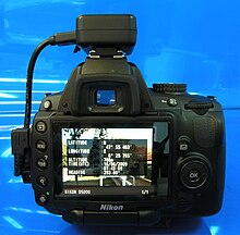
Geotag information in a JPEG photo, shown by the software gThumbGeotag information stamped onto a JPEG photo by the software GPStamperGeotagger "Solmeta N2" for the Nikon D5000 DSLR
Geotagging, or GeoTagging, is the process of adding geographical identification metadata to various media such as a geotagged photograph or video, websites, SMS messages, QR Codes or RSS feeds and is a form of geospatial metadata. This data usually consists of latitude and longitude coordinates, though they can also include altitude, bearing, distance, accuracy data, and place names, and perhaps a time stamp.
Geotagging can help users find a wide variety of location-specific information from a device. For instance, someone can find images taken near a given location by entering latitude and longitude coordinates into a suitable image search engine. Geotagging-enabled information services can also potentially be used to find location-based news, websites, or other resources.[1] Geotagging can tell users the location of the content of a given picture or other media or the point of view, and conversely on some media platforms show media relevant to a given location.
The geographical location data used in geotagging can, in almost every case, be derived from the global positioning system, and based on a latitude/longitude-coordinate system that presents each location on the earth from 180° west through 180° east along the Equator and 90° north through 90° south along the prime meridian.[citation needed]
The related term geocoding refers to the process of taking non-coordinate-based geographical identifiers, such as a street address, and finding associated geographic coordinates (or vice versa for reverse geocoding). Such techniques can be used together with geotagging to provide alternative search techniques.[citation needed]
^"GPS adds dimension to online photos". The Oklahoman. Oklahoma City, OK. Associated Press. 22 January 2008. Archived from the original on 24 September 2021. Retrieved 21 September 2020.
Geotagging, or GeoTagging, is the process of adding geographical identification metadata to various media such as a geotagged photograph or video, websites...
methods of geotagging photographs, either automatic or manual. Automatic methods provide the easiest and most precise method of geotagging an image, providing...
geotagging an image.[citation needed] Since version 3.5 of Picasa, geotagging may be done directly inside Picasa, in the Places panel. The geotagging...
There are several methods to create a Geotagged photograph (see also Geotagging). The application of this is to allow photo management applications to...
has available accessories such as: Nikon GP-1 GPS Unit for direct GPS geotagging. Third party solutions partly with 3-axis compass, data-logger, bluetooth...
metadata rather than a physical hierarchy. Geotagging can be applied to photos in albums, and any albums with geotagging can be related to a map using imapflickr...
Remote Cord or third party solutions. Nikon GP-1 GPS Unit for direct GPS geotagging. Third party solutions partly with 3-axis compass, data-logger, bluetooth...
are a few services that provide the option of geotagging images. Flickr has over 40 million geotagged photos uploaded by 400 thousand users, and still...
party remotes are also available. Nikon GP-1 GPS Unit for direct GPS geotagging. Third party solutions partly with 3-axis compass, data-logger, bluetooth...
or third-party solutions. Nikon GP-1 or GP-1A GPS Unit for direct GPS geotagging. Third-party solutions partly with three-axis compass, data-logger, bluetooth...
WGS 84 coordinates in (X)HTML geo URI scheme Geographic information system Geotagging GIS file formats North American Datum Point of interest TRANSIT system...
year's index. In 2023, the search site Crossword Solm utilizing internet geotagging, showed that Manila is the world's most loving capital city. In August...
widescreen aspect ratios as well. Users could formerly view a map of a user's geotagged photos. The feature was removed in September 2016, citing low usage. Since...
data is recorded. Some social media outlets have added capture time and geotagging that helps provide information about the context of the data as well as...
process of adding geographic information to a photograph is known as geotagging. Photo-sharing communities like Panoramio, locr or Flickr equally allow...
This is a list of notable XML schemas in use on the Internet sorted by purpose. XML schemas can be used to create XML documents for a wide range of purposes...
Mapillary is a service for sharing crowdsourced geotagged photos, developed by remote company Mapillary AB, based in Malmö, Sweden. Mapillary was launched...
0204086 W". Today, using the ICBM method of coordinates is one method of geotagging webpages or other online material. Some projects parse ICBM address included...
viewing tracks projected onto various map sources, annotating maps, and geotagging photographs based on the time they were taken. A GPX file's main components...
Tariq (29 August 2019). "Pakistan Geotagging: 098 - Nawab Sar Buland Khan And His Fort At Mankera". Pakistan Geotagging. "Muhammad Nafis". www.lakkimarwat...
 Global Information