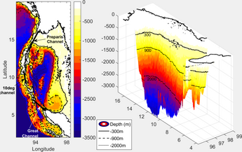
Example of a 2D and 3D model created using geophysical imaging techniques.[1]
Geophysical imaging (also known as geophysical tomography) is a minimally destructive geophysical technique that investigates the subsurface of a terrestrial planet.[2][3] Geophysical imaging is a noninvasive imaging technique with a high parametrical and spatio-temporal resolution.[4] It can be used to model a surface or object understudy in 2D or 3D as well as monitor changes.[4]
There are many applications of geophysical imaging some of which include imaging the lithosphere and imaging glaciers.[5][6] Many different techniques exist to perform geophysical imaging including seismic methods, electrical resistivity tomography, ground-penetrating radar, etc.
Types of geophysical imaging:
Electrical resistivity tomography
Ground-penetrating radar
Induced polarization
Seismic tomography and Reflection seismology
Magnetotellurics
^S. R., Kiran (2017). "General Circulation & Principal Wave Modes in Andaman Sea from Observations". SSRN Working Paper Series. doi:10.2139/ssrn.3072272. ISSN 1556-5068.
^Parsekian, A. D.; Singha, K.; Minsley, B. J.; Holbrook, W. S.; Slater, L. (2015). "Multiscale geophysical imaging of the critical zone: Geophysical Imaging of the Critical Zone". Reviews of Geophysics. 53 (1): 1–26. doi:10.1002/2014RG000465.
^Hagrey, Said Attia al (2012). "Geophysical Imaging Techniques". In Mancuso, Stefano (ed.). Measuring Roots. Springer Berlin Heidelberg. pp. 151–188. doi:10.1007/978-3-642-22067-8_10. ISBN 9783642220678. {{cite book}}: |work= ignored (help)
^ abAttia al Hagrey, Said (2007). "Geophysical imaging of root-zone, trunk, and moisture heterogeneity". Journal of Experimental Botany. 58 (4): 839–854. doi:10.1093/jxb/erl237. ISSN 0022-0957. PMID 17229759.
^Afonso, Juan Carlos; Moorkamp, Max; Fullea, Javier (2016), "Imaging the Lithosphere and Upper Mantle", Integrated Imaging of the Earth, John Wiley & Sons, Inc, pp. 191–218, doi:10.1002/9781118929063.ch10, ISBN 9781118929063
^Maurer, Hansruedi; Hauck, Christian (2007). "Geophysical imaging of alpine rock glaciers". Journal of Glaciology. 53 (180): 110–120. Bibcode:2007JGlac..53..110M. doi:10.3189/172756507781833893. ISSN 0022-1430.
and 27 Related for: Geophysical imaging information
Geophysicalimaging (also known as geophysical tomography) is a minimally destructive geophysical technique that investigates the subsurface of a terrestrial...
resistivity tomography (ERT) or electrical resistivity imaging (ERI) is a geophysical technique for imaging sub-surface structures from electrical resistivity...
Document imaging, replicating documents commonly used in business Geophysicalimaging Industrial process imaging Medical imaging, creating images of the...
In imaging spectroscopy (also hyperspectral imaging or spectral imaging) each pixel of an image acquires many bands of light intensity data from the spectrum...
Induced polarization (IP) is a geophysicalimaging technique used to identify the electrical chargeability of subsurface materials, such as ore. The polarization...
Magnetotellurics (MT) is an electromagnetic geophysical method for inferring the earth's subsurface electrical conductivity from measurements of natural...
In reflection seismology, a hydrocarbon indicator (HCI) or direct hydrocarbon indicator (DHI) is an anomalous seismic attribute value or pattern that could...
Identity preserved, an agricultural designation Induced polarization, a geophysicalimaging technique Intercept point, a measure in amplifiers and mixers Ion...
Chemical imaging 3D reconstruction Discrete tomography Geometric tomography Geophysicalimaging Industrial CT scanning Johann Radon Medical imaging MRI compared...
which began in the summer of 2010. The project uses non-invasive geophysicalimaging technique to reveal and visually recreate the landscape. According...
The Geophysical Tomography Group was part of the Institut de Physique du Globe de Paris (Jussieu Campus). During the years 1985-2000 it made developments...
Vertical electrical sounding (VES) is a geophysical method for investigation of a geological medium. The method is based on the estimation of the electrical...
Seismic tomography or seismotomography is a technique for imaging the subsurface of the Earth with seismic waves produced by earthquakes or explosions...
ISBN 0-12-475946-7. Loke, M.H. (2004). Tutorial: 2-D and 3-D electrical imaging surveys (PDF). Retrieved 2007-06-11. John Milsom, Field geophysics, John...
Here are the key details: Company Overview: Name: ION Geophysical Corporation Industry: Geophysical solutions for oil and gas Headquarters: Houston, Texas...
The Atmospheric Chemistry Suite (ACS) is a science payload consisting of three infrared spectrometer channels aboard the ExoMars Trace Gas Orbiter (TGO)...
needed] Airborne geophysical surveys also use the term "fiducial" as a sequential reference number in the measurement of various geophysical instruments during...
This image represents the driller’s view of downhole information provided by the IntelliServ Broadband Network. The top right section shows the real-time...
or complex resistivity (CR) and also complex conductivity (CC), is a geophysical survey technique and an extension of the induced polarization (IP) method...
but are not limited to borehole drilling, foundation construction and geophysical surveys. Shoreline reclamation has been actively carried out by many...
structures. Electrical resistance surveying is one of the most popular geophysical methods thanks to the fact it is a nondestructive and economically favorable...
Kyle, P.R. (2012). "Imaging of Erebus volcano using body wave seismic interferometry of Strombolian eruption coda". Geophysical Research Letters. 39...
gprMax, an open source electromagnetic simulation tool, to assess the imaging potential at the landing site. Other Mars radar experiments include SHARAD...
Martian northern hemisphere and the nature of plain filling materials," Geophysical Research Letters, 39, No. 2, 19 Jan 2012 (abstract)(article at UCI) accessed...
 Global Information