Map of Wales. Topography above 600 feet (182.88m) in pink; national parks in green.
Continent
Europe
Region
British Isles
Area
• Total
21,218 km2 (8,192 sq mi)
Highest point
Snowdon
(Welsh: Yr Wyddfa)
1,085 m (3,560 ft)
Longest river
River Severn
(Welsh: Afon Hafren)
354 km (220 mi)
Largest lake
Lake Vyrnwy
(Welsh: Llyn Efyrnwy)
4.5 km2 (1.7 sq mi)
Climate
Temperate
References
[1][2]
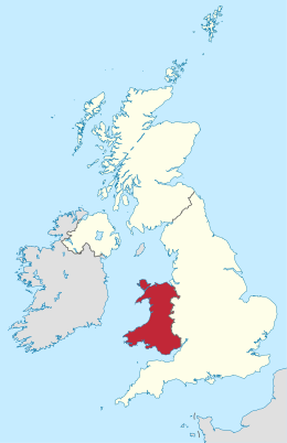
Wales is a country that is part of the United Kingdom and whose physical geography is characterised by a varied coastline and a largely upland interior. It is bordered by England to its east, the Irish Sea to its north and west, and the Bristol Channel to its south. It has a total area of 2,064,100 hectares (5,101,000 acres) and is about 170 mi (274 km) from north to south and at least 60 mi (97 km) wide. It comprises 8.35 percent of the land of the United Kingdom. It has a number of offshore islands, by far the largest of which is Anglesey. The mainland coastline, including Anglesey, is about 1,680 mi (2,704 km) in length. As of 2014, Wales had a population of about 3,092,000; Cardiff is the capital and largest city and is situated in the urbanised area of South East Wales.
Wales has a complex geological history which has left it a largely mountainous country. The coastal plain is narrow in the north and west of the country but wider in the south, where the Vale of Glamorgan has some of the best agricultural land. Exploitation of the South Wales Coalfield during the Industrial Revolution resulted in the development of an urban economy in the South Wales Valleys, and the expansion of the port cities of Newport, Cardiff and Swansea for the export of coal. The smaller North Wales Coalfield was also developed at this time, but elsewhere in the country, the landscape is rural and communities are small, the economy being largely dependent on agriculture and tourism. The climate is influenced by the proximity of the country to the Atlantic Ocean and the prevailing westerly winds; thus it tends to be mild, cloudy, wet and windy.
^"Standard Area Measurements (Latest) for Administrative Areas in the United Kingdom (V2)". Open Geography Portal. Office for National Statistics. 5 April 2023. Retrieved 3 December 2023.
^"A Beginners Guide to UK Geography (2023)". Open Geography Portal. Office for National Statistics. 24 August 2023. Retrieved 9 December 2023.
and 25 Related for: Geography of Wales information
Wales is a country that is part of the United Kingdom and whose physical geography is characterised by a varied coastline and a largely upland interior...
of Ireland Geographyof Scotland GeographyofWales List of caves in the United Kingdom List of conurbations in the United Kingdom List of places in the...
Geographyof Scotland GeographyofWales Geology of England Climate of England List of islands of England List of rivers of England List of lakes of England...
Wales (Welsh: Cymru [ˈkəm.rɨ] ) is a country that is part of the United Kingdom. It is bordered by the Irish Sea to the north and west, England to the...
Railway Vale of Rheidol Railway GeographyofWales Kingdom of Dyfed Mid Wales North Wales Principality of Deheubarth South Wales South West Wales Traws Link...
South Wales. South East Wales West Wales Mid Wales North WalesGeographyofWales Subdivisions ofWales M4 corridor South Wales coalfield South Wales Valleys...
Swansea Newport Bangor St Asaph St Davids Wrexham Wales has seven cities as of September 2022. Bangor is Wales' oldest cathedral city, whereas St Davids is...
provided as an overview of and topical guide to geography: Geography – study of Earth and its people. an academic discipline – a body of knowledge given to...
delegated to them by the Government of New South Wales. The Australian Bureau of Statistics has moved towards a new Geographical Classification called the Australian...
North Wales (Welsh: Gogledd Cymru) is a region ofWales, encompassing its northernmost areas. It borders mid Wales to the south, England to the east, and...
areas of temperate rainforests in Wales, also termed a "Celtic rainforest". They are located largely in river valleys, adjacent to the sea, on Wales' western...
modern English. Toponymy in Wales reveals significant features of the country's history and geography, as well as the development of the Welsh language. Its...
List of Welsh areas by percentage of Welsh-speakers Welsh Government GeographyofWales List of communities in Wales List of electoral wards in Wales ISO...
ISBN 978-0-948469-14-5. Thomas, Alan R (1973). Linguistic GeographyofWales. Cardiff: University ofWales Press for Board of Celtic Studies. "Teach Yourself Welsh". Cymdeithas...
geography), human impact characteristics (human geography), and the interaction of humanity and the environment (environmental geography). Geographic...
native to Wales. Wales is one of the four countries of the United Kingdom. The majority of people living in Wales are British citizens. In Wales, the Welsh...
Wales. The table below lists Wales' longest rivers including (in italics) those only partly in Wales. Centre points of the United Kingdom Geography of...
2016. "Geography - NUTS: Wales: Directory". Corporate Joint Committee for South West Wales One Big Garden (gardens and parkland in South West Wales) Visit...
in Wales Ysgyryd Fawr Sugar Loaf, Monmouthshire Offa's Dyke Tintern Abbey Pontypool Park Blaenafon World Heritage Site GeographyofWales Mid Wales North...
1997) Geography portal Oceania portal Australia portal New South Wales portal Geology of New South Wales Index of Australia-related articles Outline of Australia...
Wales has traditionally been divided into a number of ambiguous and ill-defined areas described as regions, reflecting historical, geographical, administrative...
 Global Information