Land borders: Western Australia, Northern Territory, Queensland, New South Wales, Victoria
Highest point
Mount Woodroffe 1,435 m (4,708 ft)
Lowest point
Lake Eyre -15 m (49 ft)
Longest river
Murray River 683 km (424 mi)
Largest lake
Lake Eyre 9690 km2
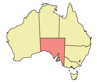
The geography of South Australia incorporates the south central part of the continent of Australia. It is one of the six states of Australia. South Australia is bordered on the west by Western Australia, to the north by the Northern Territory, Queensland to the northeast, and both New South Wales and Victoria to the east. South Australia's south coast is flanked by the Great Australian Bight and the Southern Ocean.[4]
The northern and western parts of the state are extremely arid, in central Australia, dominated by Lake Eyre and Lake Torrens, mostly dry salt lakes. This arid area is sparsely populated, with many large cattle stations, and significant areas protected as national parks, or as Aboriginal lands. The only significant roads through these areas are the Stuart Highway north from Port Augusta to the Northern Territory, the Eyre Highway across the Nullarbor Plain to Western Australia, and the Barrier Highway east to Broken Hill in New South Wales. These highways have corresponding railways: the Trans-Australian Railway going west and east, and the Adelaide–Darwin railway going north.
The coastline includes cliffs against the Great Australian Bight including the western side of Eyre Peninsula. The coast is less rugged on Spencer Gulf and Gulf St Vincent (separated by Yorke Peninsula), Fleurieu Peninsula, Encounter Bay and The Coorong. Bordering the east of Gulf St Vincent is the Temperate Grassland of South Australia.
The highest point in the state is Mount Woodroffe at 1,435 metres (4,708 ft) in the Musgrave Ranges in the northwest corner of the state.[5] The main range is the Mount Lofty Ranges and Flinders Ranges extending approximately 800 kilometres (497 mi) from Fleurieu Peninsula along the eastern sides of Gulf St Vincent and Spencer Gulf respectively. About half the state is less than 150 m above sea level.[6]
The arid north is delineated from the more fertile southeast by Goyder's Line, first surveyed in the 1860s, and which has proven to be a remarkably accurate northern boundary marking where sustainable agriculture can be carried out. Three deserts are contained within South Australia's borders: Great Victoria Desert, Strzelecki Desert and Sturt Stony Desert.[7]
East of the Mount Lofty Ranges, the Murray River flows west from New South Wales and Victoria, then south adjacent to the ranges. The Murray River is the only large, permanent river in the state.[6]
^Area of Australia - States and Territories Geoscience Australia. Retrieved 9 January 2022.
The geographyofSouthAustralia incorporates the south central part of the continent ofAustralia. It is one of the six states ofAustralia. South Australia...
in the world. The population ofAustralia is concentrated along the eastern and south-eastern coasts. The geographyof the continent is extremely diverse...
SouthAustralia (commonly abbreviated as SA) is a state in the southern central part ofAustralia. It covers some of the most arid parts of the country...
August 2010. MacKay (1864, 1885) Elements of Modern Geography, p. 283 "Aboriginal Australians". National Geographic. 8 February 2019. Archived from the original...
AustralianGeographic is a media business that produces the AustralianGeographic and AustralianGeographic Adventure magazine, australiangeographic.com...
[ˈd̪̥aɳɖaɲa]) is the capital and largest city ofSouthAustralia, and the fifth-most populous city in Australia. "Adelaide" may refer to either Greater Adelaide...
proportion of the population who have a deep understanding of the geographyof their state is limited. The geographyof Western Australia has been of interest...
Australia, officially the Commonwealth ofAustralia, is a sovereign country comprising the mainland of the Australian continent, the island of Tasmania...
New South Wales (commonly abbreviated as NSW) is a state on the east coast ofAustralia. It borders Queensland to the north, Victoria to the south, and...
Sydney is the capital city of the state of New South Wales and the most populous city in Australia. Located on Australia's east coast, the metropolis...
The definition of a city in Australia varies between the states. State capital cities may include multiple local government areas (LGAs) within their boundaries...
The South Pole, also known as the GeographicSouth Pole or Terrestrial South Pole, is the southernmost point on Earth and lies antipodally on the opposite...
Settlement geography is a branch of human geography that investigates the Earth's surface's part settled by humans. According to the United Nations' Vancouver...
/ -26; 129 Today SouthAustralia's land borders are defined to the west by the 129° east longitude (129° east) with Western Australia, to the north by...
Regions of New South Wales Geographyof Sydney https://www.ga.gov.au/scientific-topics/national-location-information/dimensions/area-of-australia-states-and-territories...
Government of New South Wales. The Australian Bureau of Statistics has moved towards a new Geographical Classification called the Australian Statistical...
federal government. Australia has six federated states: New South Wales (including Lord Howe Island), Queensland, SouthAustralia, Tasmania (including...
Australia has a wide variety of climates due to its large geographical size. The largest part ofAustralia is desert or semi-arid. Only the south-east...
Flora of Eastern Ghats: Hill ranges ofsouth east India. Vol. 1. Daya Books. p. 1. ISBN 81-87498-49-8. Kenneth Pletcher (2010). The Geographyof India:...
Geographyof Asia reviews geographical concepts of classifying Asia, the central and eastern part of Eurasia, comprising 58 countries and territories....
In geography, location or place are used to denote a region (point, line, or area) on Earth's surface. The term location generally implies a higher degree...
together with the continent of Australia to form the geographical region Oceania. In geology, a continent is defined as "one of Earth's major landmasses, including...
The AustralianGeography Competition is an Australia-wide competition run by the Royal Geographic Society of Queensland and the AustralianGeography Teachers...
have argued that Australia and New Zealand are marginalized in similar ways to other Global South countries, due to their geographical isolation and location...
mainland of the territory governed by the Commonwealth ofAustralia, and the term, along with continental Australia, can be used in a geographic sense to...
 Global Information