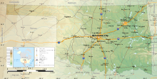
Oklahoma topographical mapGeographic map of Oklahoma
The Geography of Oklahoma encompasses terrain and ecosystems ranging from arid plains to subtropical forests and mountains. Oklahoma contains 10 distinct ecological regions, more per square mile than in any other state by a wide margin.[1] It is situated in the Great Plains and U.S. Interior Highlands region near the geographical center of the 48 contiguous states. Usually considered part of the South Central United States, Oklahoma is bounded on the east by Arkansas and Missouri, on the north by Kansas, on the northwest by Colorado, on the far west by New Mexico, and on the south and near-west by Texas.
The state has four primary mountain ranges: the Arbuckle Mountains, the Wichita Mountains, the Ozark Mountains and the Ouachita Mountains.[2] Part of the U.S. Interior Highlands region, the Ozarks and Ouachitas form one of the only major highland regions between the Rocky Mountains and the Appalachians.[3]
A portion of the Flint Hills stretches into north-central Oklahoma, and in the state's southeastern corner, Cavanal Hill is officially regarded as the world's tallest hill; at 1,999 feet (609 m), it fails the definition of a mountain by one foot.[4] More than 500 named creeks and rivers make up Oklahoma's waterways, and with 200 lakes created by dams, it holds the highest number of reservoirs in the nation.[4]
Oklahoma covers an area of 69,898 square miles (181,030 km2), with 68,667 square miles (177,850 km2) of land and 1,231 square miles (3,190 km2) of water, making it the 20th-largest state in the United States.[5] Generally, it is divided into seven geographical regions: Green Country, or Northeast Oklahoma, Southeastern Oklahoma, Central Oklahoma, South Central Oklahoma, Southwest Oklahoma, Northwest Oklahoma, and the Oklahoma Panhandle.
^"Oklahoma, All Terrain Vacation". TravelOK. TravelOK.com. 2006-01-12. Archived from the original on July 9, 2006. Retrieved 2006-07-15.
^Cite error: The named reference The Geography of Oklahoma was invoked but never defined (see the help page).
^"Managing Upland Forests of the Midsouth". USDA Forest Service. 2007-03-07. Archived from the original on 2008-06-22. Retrieved 2007-07-31.
^ ab"About Oklahoma". TravelOK.com. 2007. Archived from the original on 2006-07-07. Retrieved 2006-07-10.
^"Land and Water Area of States, 2000". Information Please. 2000. Retrieved 2006-11-22.
and 23 Related for: Geography of Oklahoma information
The GeographyofOklahoma encompasses terrain and ecosystems ranging from arid plains to subtropical forests and mountains. Oklahoma contains 10 distinct...
Oklahoma (/ˌoʊkləˈhoʊmə/ OHK-lə-HOH-mə; Choctaw: Oklahumma, pronounced [oklahómma]) is a landlocked state in the South Central region of the United States...
area, Chesapeake Boathouse and downtown Oklahoma City List of rivers ofOklahoma U.S. Geological Survey Geographic Names Information System: North Canadian...
Oklahoma City (/ˌoʊkləˈhoʊmə -/ ), officially the City ofOklahoma City, and often shortened to OKC, is the capital and most populous city of the U.S...
Land of the Red Man Sooner State Adjectival: Oklahoma Demonyms: Oklahoman Sooner (historic) Boomer (historic) Okie (archaic) GeographyofOklahoma Oklahoma...
reservoir in northwestern Oklahoma City, Oklahoma. It was built in the 1940s to expand the water supply for the city ofOklahoma City, It is named after...
Territory) is a salient in the extreme northwestern region of the U.S. state ofOklahoma, consisting of Cimarron County, Texas County and Beaver County, from...
provided as an overview of and topical guide to geography: Geography – study of Earth and its people. an academic discipline – a body of knowledge given to...
(including the Texas Hill Country), Eastern New Mexico, western Oklahoma including the Oklahoma Panhandle and the Wichita Mountains, southeastern Colorado...
Oklahoma Lake is located in north east Oklahoma City in the Canadian river valley and borders the North Canadian River by Westminster Road. The surface...
The Oklahoma City Oil Field is one of the world's giant petroleum fields and is located in Oklahoma City, Oklahoma in the United States of America. The...
constituent of a combined statistical area. Geography portal United States portal Oklahoma portal GeographyofOklahoma Demographics ofOklahoma Revised Delineations...
The Oklahoma City bombing was a domestic terrorist truck bombing of the Alfred P. Murrah Federal Building in Oklahoma City, Oklahoma, United States, on...
Indian reservations in Oklahoma Indian country jurisdiction Off-reservation trust land Tribal sovereignty in the United States Geography, US Census Bureau...
facilities in the state ofOklahoma. Through affiliates Integris Health Inc. operates 16 hospitals and has health providers in 49 Oklahoma towns and cities....
Scouting in Oklahoma has a long history, from the 1910s to the present day, serving thousands of youth in programs that suit the environment in which they...
University ofOklahoma (OU) is a public research university in Norman, Oklahoma, United States. Founded in 1890, it had existed in Oklahoma Territory near...
Llano Estacado and Central Great Plains of western Oklahoma and Texas, east of the Pecos River and north of the Edwards Plateau. Cozzens, Peter (2001)...
Oklahoma is a state located in the Southern United States. According to the 2020 census, Oklahoma is the 28th most populous state with 3,959,353 inhabitants...
city limits ofOklahoma City, Oklahoma. Lake Overholser is formed by Overholser Dam on the North Canadian River in Oklahoma County, Oklahoma. The lake is...
Plains National Wildlife Refuge in Alfalfa County, Oklahoma in the United States named because of the salt flats in the area and for the Salt Fork Arkansas...
part of the state ofOklahoma and the Texas Panhandle, and extending into southwestern Kansas and southeastern Colorado. The basin covers an area of 50...
 Global Information