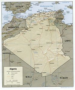
Land boundaries: 6,343 km Morocco 1,559 km, Mali 1,376 km, Libya 982 km, Tunisia 965 km, Niger 956 km, Mauritania 463 km, Western Sahara 42 km
Maritime claims
32–52 nm
Highest point
Mount Tahat, 3,003 m
Lowest point
Chott Melrhir, −40 m (131 ft)
Longest river
Chelif River, 230 km
Climate
arid to semiarid
Terrain
mostly high plateau and desert, mountains, narrow coastal plain[1]
Natural resources
petroleum, natural gas, iron ore, phosphates, uranium, lead, zinc[1]
Natural hazards
earthquakes, mudslides, floods, droughts
Environmental issues
soil erosion, desertification, pollution
Exclusive economic zone
126,353 km2 (48,785 sq mi)
Algeria map of Köppen climate classification zonesSatellite map of AlgeriaShaded relief map of Algeria with settlements and roads
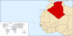
Algeria comprises 2,381,740 square kilometres (919,590 sq mi) of land, more than 80% of which is desert, in North Africa, between Morocco and Tunisia.[2][1] It is the largest country in Africa.[1] Its Arabic name, Al Jazair (the islands), is believed to derive from the rocky islands along the coastline of the Mediterranean Sea.[2] The northern portion, an area of mountains, valleys, and plateaus between the Mediterranean and the Sahara Desert, forms an integral part of the section of North Africa known as the Maghreb.[2] This area includes Morocco, Tunisia, and the northwestern portion of Libya known historically as Tripolitania.[2]
^ abcdCite error: The named reference factbook was invoked but never defined (see the help page).
^ abcdDeeb, Mary-Jane (1993). "Physical Setting". In Metz, Helen Chapin (ed.). Algeria: a country study. Washington, D.C.: Federal Research Division, Library of Congress. pp. 69–76. OCLC 44230753. This article incorporates text from this source, which is in the public domain.{{cite encyclopedia}}: CS1 maint: postscript (link)
and 24 Related for: Geography of Algeria information
Algeria comprises 2,381,740 square kilometres (919,590 sq mi) of land, more than 80% of which is desert, in North Africa, between Morocco and Tunisia...
in the fertile north and the Sahara dominating the geographyof the south. Algeria covers an area of 2,381,741 square kilometres (919,595 sq mi), making...
Zibans[fr] The Algerian Sahara Grand Erg Oriental and Grand Erg Occidental Souf[fr] Tassill n'Ajjer Tanezrouft GeographyofAlgeria "Algeria.com | Regions...
also known as Colonial Algeria, was the period ofAlgerian history when the country was a colony and later an integral part of France. French rule in...
romanized: al-Jazāʾir) is the capital and largest city ofAlgeria, located in the north-central part of the country. The city's population at the 2008 census...
baladiyahs (municipalities). The name of a province is always that of its capital city. According to the Algerian constitution, a wilaya is a territorial...
The communes ofAlgeria (Arabic: بلدية (singular)) form the third level of administrative subdivisions ofAlgeria. As of 2002, there were 1,541 municipalities...
(baladiyahs) ofAlgeria, see List of municipalities ofAlgeria, and for the postal code of an Algerian city, see list of postal codes ofAlgerian cities. Adrar...
Algerian War (also known as the Algerian Revolution or the Algerian War of Independence) was a major armed conflict between France and the Algerian National...
The official languages ofAlgeria are Arabic and Tamazight (Berber), as specified in its constitution since 1963 for the former and since 2016 for the...
The economy ofAlgeria deals with Algeria's current and structural economic situation. Since independence in 1962, Algeria has launched major economic...
the highest mountain in Algeria. It sits at an elevation of 2,908 metres (9,541 ft). Other sources indicate an elevation of 3,003 metres (9,852 ft)....
Haggett, Peter (2001). Encyclopedia of World Geography. Marshall Cavendish. ISBN 0-7614-7289-4. Ham, Anthony (2007). Algeria. Lonely Planet. p. 188. Keenan...
Much of the history ofAlgeria has taken place on the fertile coastal plain of North Africa, which is often called the Maghreb (or Maghreb). North Africa...
borders ofAlgeria and Mali, west of the Hoggar Mountains. Along with the Libyan Desert it is one of the most desolate and most arid parts of the Sahara...
provided as an overview of and topical guide to geography: Geography – study of Earth and its people. an academic discipline – a body of knowledge given to...
French conquest ofAlgeria eventually led to French colonial rule until 1962. In ports along the Maghreb coast conquered after the Emirate of Granada fell...
southern Tunisian Governorates, Gafsa, Kebili and Tozeur with adjacent parts ofAlgeria and Libya. The region is characterised by bare pink hills with oases and...
exploited. GeographyofAlgeria Mahjoubi, Ammar; Salama, Pierre (1981). "The Roman and post-Roman period in North Africa". General History of Africa: Volume...
from France in 1962, Algeria has pursued an activist foreign policy. In the 1960s and 1970s, Algeria was noted for its support of Third World policies...
junction of the Spanish geodetic network with Algeria. This connection was a remarkable enterprise where triangles with a maximum length of 270 km were...
عنّابة, lit "Place of the Jujubes"), formerly known as Bon, Bona and Bône, is a seaport city in the northeastern corner ofAlgeria, close to the border...
 Global Information


 This article incorporates text from this source, which is in the public domain.