Global Information Lookup Global Information

Garrigill information


Garrigill
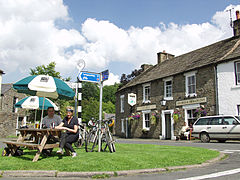
Garrigill Village Green
Garrigill is located in the former Eden District
Garrigill
Garrigill
Location in Eden, Cumbria
Garrigill is located in Cumbria
Garrigill
Garrigill
Location within Cumbria
OS grid referenceNY745415
Civil parish
  • Alston Moor
District
  • Eden
Shire county
  • Cumbria
Region
  • North West
CountryEngland
Sovereign stateUnited Kingdom
Post townALSTON
Postcode districtCA9
Dialling code01434
PoliceCumbria
FireCumbria
AmbulanceNorth West
UK Parliament
  • Penrith and The Border
List of places
UK
England
Cumbria
54°46′01″N 2°23′49″W / 54.767°N 2.397°W / 54.767; -2.397

Garrigill, Cumbria is a small village in the North Pennine region of the UK, situated on the banks and close to the source of the River South Tyne. Historically part of Cumberland, today it is within the Garrigill ward of the civil parish of Alston Moor within the district of Eden. In 1870-72 the chapelry had a population of 1447.[1]

The village's name should not be confused with the hamlet of Galligill in the Nent valley, also within Alston Moor.

The village's former name is Garrigill-Gate and it was earlier known as Gerard's Gill. (Gill is a Norse word for a steep-sided valley).

At its peak Garrigill was home to 1,000 people, mainly employed in the lead mining industry; now its population numbers less than 200. While villagers were at one time mainly employed in local livestock farming, these days the population is fairly evenly divided between those in local employment, the self-employed and retirees. Garrigill Post Office is a traditional village store which has not changed substantially since the 1950s and is an attraction to many visitors, although at one time the village had four shops including a Co-op store.

View of row of houses including the Post Office. The boarded-up pub 'The George and Dragon' on the left.

For many years there has been one pub in the village, the 'George & Dragon', but this was closed from September 2009 to December 2010 and again from November 2013 to 3 April 2015. It subsequently closed again and re-opened on 25 August 2017. Before the mid-20th century there was a second pub, The Old Fox, next to the church.

The centre of the village is the green which the post office and George & Dragon overlook with the church and village hall nearby, but at either end of the village proper are the areas of Gatefoot and Gatehead, whilst on the village's outskirts are the settlements of Beldy, Crossgill, Loaning (pronounced Lonnin') Head and Ashgillside. There are two water pumps in the village, one on the green and one (which still works) by the bridge.

Ashgill Force in flood

At Ashgillside and Beldy there are waterfalls namely Ashgill Force and Thortergill Force. Thortergill Force (formerly known to locals as Lady's Walk) was previously able to be accessed by the public, but access has now been closed by the current landowners.

The closest town is Alston, four miles away to the north.

The parish church of St John was for centuries a chapel of ease to St Augustine's at Alston but was promoted to full parish status in the 1980s. It is served by a team vicar based at Alston who also serves the churches at Nenthead, Knarsdale, Kirkhaugh and Lambley. There used to be several non-conformist chapels at or just outside Garrigill as well. Unlike most of the rest of Cumbria the parishes of Alston, Nenthead and Garrigill are within the Diocese of Newcastle not the Diocese of Carlisle.

At nearby Tynehead, now only a single house but once a thriving mining community, there was until the 1930s a primary school which was the highest school there has ever been in England. Garrigill's own school, located at Gatefoot on the Leadgate road, closed in the 1960s.

  1. ^ "History of Garrigill, in Eden and Cumberland". A Vision of Britain through Time. Retrieved 13 January 2022.

and 25 Related for: Garrigill information

Request time (Page generated in 0.5454 seconds.)

Garrigill

Last Update:

Garrigill, Cumbria is a small village in the North Pennine region of the UK, situated on the banks and close to the source of the River South Tyne. Historically...

Word Count : 731

Alston Moor

Last Update:

Alston Moor, formerly known as Alston with Garrigill, is a civil parish and electoral ward in the Westmorland and Furness district, in the ceremonial...

Word Count : 1213

Cumberland

Last Update:

board of guardians. Cumberland was divided into nine unions: Alston with Garrigill, Bootle, Brampton, Carlisle, Cockermouth, Longtown, Penrith, Whitehaven...

Word Count : 2171

Rural district

Last Update:

only one parish (for example, Tintwistle Rural District, Alston with Garrigill Rural District, South Mimms Rural District, King's Lynn Rural District...

Word Count : 769

Pennine Way

Last Update:

Mankinholes Lothersdale Malham Horton Hawes Keld Bowes Langdon Beck Dufton Garrigill Alston Once Brewed Bellingham Byrness The Cheviot Kirk Yetholm A survey...

Word Count : 3097

List of generic forms in place names in the British Isles

Last Update:

-gart as in Stuttgart gill, ghyll ON ravine, narrow gully Gillamoor, Garrigill, Dungeon Ghyll glen, glyn SG, I, W narrow valley, dale Rutherglen, Glenarm...

Word Count : 1112

Eden District

Last Update:

the Local Government Act 1972, from Penrith Urban District, Alston with Garrigill Rural District and Penrith Rural District, all in Cumberland, and Appleby...

Word Count : 681

Sea to Sea Cycle Route

Last Update:

undulating ride as the C2C meanders through old lead-mining villages, such as Garrigill, Nenthead and Rookhope, and down into the Durham Dales before crossing...

Word Count : 1002

Leath

Last Update:

that is the former Penrith urban and rural districts and the Alston with Garrigill Rural District. Market towns in the ward were Penrith (the largest settlement...

Word Count : 298

List of rivers of England

Last Update:

Burn (L) (known as Sheild Water upstream) Natress Gill (R) Dry Burn (L) Garrigill Burn (R) Ash Gill (R) River North Tyne (Ls) Erring Burn (L) Swin Burn...

Word Count : 10761

Ashgill Force

Last Update:

B6277 (which crosses a bridge over the beck just above the falls) or from Garrigill village, downstream of the fall. The beck downstream of the main fall...

Word Count : 262

List of places in Cumbria

Last Update:

Frizington Gaisgill, Galligill, Gamblesby, Gamelsby, Garlands Garnett Bridge, Garrigill, Garsdale, Garsdale Head Garth Row, Garths, Gatebeck, Gatefoot, Gatesgarth...

Word Count : 1274

Listed buildings in Alston Moor

Last Update:

grade. The parish contains the market town of Alston, the villages of Garrigill and Nenthead, smaller communities, and the surrounding countryside. Nenthead...

Word Count : 2336

Thomas Forster Brown

Last Update:

known for his activity in South Wales. Thomas Forster Brown was born in Garrigill, Cumberland in 1835. He learned his trade from Thomas Emerson Forster...

Word Count : 334

Penrith Rural District

Last Update:

Ward of Cumberland but excluding the parishes of Penrith and Alston with Garrigill. The area had been a rural sanitary district prior to the Local Government...

Word Count : 283

William Alston Hutchinson

Last Update:

politician, manufacturer, merchant and colliery director. He was born at Garrigill near Cumbria in Cumberland to storekeeper Thomas Hutchinson and Jane Phillipson...

Word Count : 227

List of crossings of the River Tyne

Last Update:

1852 54°49′17″N 2°26′46″W Alston bridge  A686 road Alston 1836 54°48′34″N 2°26′34″W Garrigill Bridge  Unclassified road Garrigill 54°46′8″N 2°23′50″W...

Word Count : 399

Civil parishes in Cumbria

Last Update:

Retrieved 26 October 2010 A Vision of Britain Through Time : Alston with Garrigill Rural District Archived 2011-06-28 at the Wayback Machine Retrieved 26...

Word Count : 1874

CA postcode area

Last Update:

Greenhead, Lambley, Slaggyford Cumberland, Northumberland CA9 ALSTON Alston, Garrigill, Nenthead, Kirkhaugh Westmorland and Furness, Northumberland CA10 PENRITH...

Word Count : 173

Pennine Journey

Last Update:

Lambley Greenhead Slaggyford Housesteads Hadrians Wall Alston Chollerford Garrigill Hexham Cross Fell Milburn Blanchland Dufton Rookhope Appleby Westgate...

Word Count : 909

Serpierite

Last Update:

by acid mine drainage from the open workings. At the Tynebottom Mine, Garrigill, Cumbria, England, post-mining deposits have been found containing serpierite...

Word Count : 1349

List of rural and urban districts in England in 1973

Last Update:

District Successor Alston with Garrigill Rural District Eden (Cumbria) Border Rural District Carlisle (Cumbria) Cockermouth Rural District Allerdale (Cumbria)...

Word Count : 410

Moorhouse and Cross Fell

Last Update:

extends roughly from an arc through the villages of Gamblesby, Leadgate and Garrigill southward as far as Milburn in the west and Cow Green Reservoir in the...

Word Count : 723

Thomas Emerson Forster

Last Update:

mining engineer. Thomas Emerson Forster was born on 20 October 1802 at Garrigill, a hamlet on the left bank of the South Tyne river in Cumberland. The...

Word Count : 525

List of churches in Eden District

Last Update:

threlkeldchurch.org.uk. Retrieved 15 April 2017. ""Church without walls" call as Garrigill chapel closes". www.cwherald.com. Retrieved 15 April 2017. "Churches facing...

Word Count : 938

PDF Search Engine © AllGlobal.net