Volcanic island in the Delarof Islands, Alaska, U.S.
South flank of Gareloi Volcano, April 2003.Gareloi's Location in Alaska.NASA Gareloi Island.
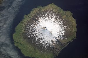
Gareloi (Russian: Горелый) or Anangusook (Aleut: Anangusix̂[1]) is a volcanic island in the Delarof Islands of the Aleutian Islands of Alaska. It is located between the Tanaga Pass and the Amchitka Pass.
The island is 6 miles (9.7 km) in length and 5 miles (8.0 km) wide. Its land area is 25.95 square miles (67.2 km2), making Gareloi the largest island in the Delarof group. Gareloi Volcano, a stratovolcano, is situated in the center of the island which reaches a height of 5,161 feet (1,573 m). On the other side of a small saddle lies another peak of the island however it does not equal the height of Mount Gareloi. The island is uninhabited.
Coastal cliffs provide nesting habitat for more than 600,000 seabirds, mostly for crevice nesting auklets. Least Auklets account for 62% of the colony, Crested Auklets for 30%, and Parakeet Auklets for 6%. Each of these species is present on the island in numbers exceeding 1% of their global populations.[2]
The island consists of lava rock, black lava, eroded lava, and ashes; the lower slopes and valleys are covered with grass and tundra in many places. The shores have steep cliffs with rocks and boulders at the base; boulders, pinnacles, and rocks awash extend around the shoreline. Heavy kelp surrounds most of the island, and extends offshore to 10 fathoms (18 m). Depths of 10 fathoms or more are within 0.5 miles (800 m) of the island. A trapper's hut is on the beach above the N shore of Gareloi Island.[3]
Gareloi's northern, slightly higher peak is on the southern rim of a crater about 330 yards (300 m) across, which contains several active fumaroles. Thirteen younger craters, from 87 yards (80 m) to 1 mile (1,600 m) in diameter, are aligned along a south-southeast trending fissure that extends from strandline to the southern summit. These craters formed during a major explosive eruption in 1929 that also produced four blocky lava flows, and a blanket of grassy andesitic tuff that covers an area roughly 1.5 by 3 miles (2.4 by 4.8 km) on the volcano's southeast flank.
Gareloi Volcano had four confirmed eruptions in the 1980s and one unconfirmed eruption in 1996. All but one of them were considered explosive eruptions. In Spring and Summer 2007 there was a period of increased seismic activity on Gareloi Island, sometimes reaching 40 earthquakes per day.[4]
^Bergsland, K. (1994). Aleut Dictionary. Fairbanks: Alaska Native Language Center.
^Audubon Important Bird Areas - Gareloi Island Archived 2011-07-19 at the Wayback Machine
^U.S. Coast Pilot 9, Chapter 7, Aleutian Islands
^"Alaska Volcano Observatory, Gareloi description and statistics". Archived from the original on 2009-04-28. Retrieved 2010-05-24.
Gareloi (Russian: Горелый) or Anangusook (Aleut: Anangusix̂) is a volcanic island in the Delarof Islands of the Aleutian Islands of Alaska. It is located...
Mount Gareloi, or Gareloi Volcano, is a stratovolcano in the Aleutian Islands of Alaska, United States, about 1,259 miles (2,026 km) from Anchorage. Gareloi...
Island Delarof Islands (Naahmiĝun tanangis) Dora Island Eddy Island (Ugidaagamax) Egg Island (Ugalĝa) Elf Island Fenimore Rock (Taxchisax̂) Gareloi Island...
east, GareloiIsland, Tanaga Island, Kanaga, Adak Island, Kagalaska Island, Great Sitkin Island, Atka Island, Amlia, and Seguam Island. The islands are...
Islands GareloiIsland Amatignak Island Ilak Island Kavalga Island Ogliuga Island Skagul Island Tanadak Island Ugidak Island Ulak Island Unalga Island Rat...
Carlisle Island. The summit of Gareloi Volcano is the highest point of GareloiIsland. The summit of Korovin Volcano is the highest point of Atka Island. The...
29 ft) from NGVD 29 to NAVD 88. The summit of Gareloi Volcano is the highest point of GareloiIsland. Gareloi Volcano is the westernmost ultra-prominent...
colonies are also present on Kiska Island, GareloiIsland, Semisopochnoi Island, Bogoslof Island, and several others. The islands are also frequented by vagrant...
This is a list of islands of the United States, as ordered by area. It includes most islands with an area greater than 20 square miles (approximately 52...
It is located just 1 km (0.62 mi) east of Ogliuga Island and 17 km (11 mi) southeast of GareloiIsland. Bergsland, K. (1994). Aleut Dictionary. Fairbanks:...
Gareloi Volcano is the apex of GareloiIsland in the Aleutian Islands of Alaska. Kiska Volcano is the apex of Kiska Island in the Aleutian Islands of...
Skagul Island and 17 km (11 mi) southeast of GareloiIsland. There is an abandoned US military airfield named Ogliuga Island Army Airfield on the island after...
29 ft) from NGVD 29 to NAVD 88. The summit of Gareloi Volcano is the highest point of GareloiIsland. Gareloi Volcano is the westernmost ultra-prominent...
Frances Mount Francis Mount Gakona Mount Gareloi, active stratovolcano that forms the summit of GareloiIsland. Westernmost ultra-prominent summit of greater...
near Cold Bay Mount Edgecumbe on Kruzof Island near Sitka Mount Gareloi on GareloiIsland in the Andreanof Islands group Mount Griggs in the Aleutian Range...
Large seabird colonies are also present at Kiska, Gareloi, Semisopochnoi, Bogoslof, and others. The islands are also frequented by vagrant Asiatic birds,...
Passing just west of GareloiIsland, Alaska, United States (at 51°47′N 178°52′W / 51.783°N 178.867°W / 51.783; -178.867 (GareloiIsland)) Passing just...
Aleutian Islands of Alaska. Gareloi Volcano is the apex of GareloiIsland in the Aleutian Islands of Alaska. Kiska Volcano is the apex of Kiska Island in the...
Semisopochnoi and Gareloi) to the Gulf of Alaska and north to the islands of the Bering Sea (St. Lawrence Island, Pribilof Islands, St. Matthew Island). Auklets...
Islands, Alaska. The Delarofs consist of 11 named islands: Amatignak, Gareloi, Ilak, Kavalga (Qavalĝa), Ogliuga (Aglaga), Skagul (Sxaĝulax̂), the Tag...
Frosty Gareloi Volcano Great Sitkin Mount Gilbert Mount Griggs Hayes Volcano Mount Iliamna Isanotski Peaks Mount Kaguyak Mount Kanaga Kasatochi Island Mount...
summer's heat and cyclists, and has been recently designated as the Sky Island Parkway, part of the US National Scenic Byway system. 2010 saw the inaugural...
In Conrad A. Istock and Robert S. Hoffmann, eds., Storm over a Mountain Island: Conservation Biology and the Mt. Graham Affair, pp. 100–20 (Tucson: University...
 Global Information